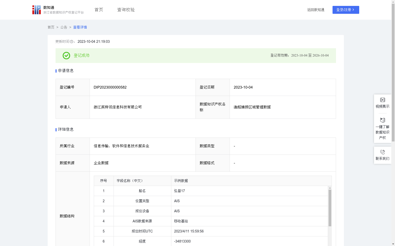
渔船捕捞区域管理数据
收藏浙江省数据知识产权登记平台2023-10-04 更新2024-05-08 收录
下载链接:
https://www.zjip.org.cn/home/announce/trends/4081
下载链接
链接失效反馈官方服务:
资源简介:
判断渔船是否在合法区域捕鱼,帮助渔业公司及管理部门更高效地监管渔船作业。在船舶实时上报AIS船位数据的过程中,根据需要船位的经纬度信息以及已经设定好的合法捕捞区的区域经纬度点组合进行一系列操作。首先,会运用地球球体上两点计算距离的算法来计算船位点到每两个组成点之间的距离。这个算法可以有效地帮助我们确定最短距离,即船位点到每个组成区域的距离。
通过这个最短距离,可以判断船位点是否在合法的捕捞区内。如果最短距离小于或等于某个预设阈值,那么可以判定该船位点位于合法的捕捞区域内;反之,如果最短距离大于该阈值,则说明船位点可能已经越界进入了非法捕捞区域。
当发现船位点可能越界时,将及时触发报警机制,以确保及时采取措施防止越界行为的发生。这些报警措施可以包括发送警报通知给相关的监管部门或人员,启动自动导航系统调整航向以避免进一步越界,或者采取其他必要的紧急措施来确保船舶的安全和合规运营。
This dataset is developed to identify whether fishing vessels are conducting fishing operations within legally approved fishing areas, assisting fishing enterprises and regulatory authorities in more efficiently supervising fishing vessel activities. During the real-time reporting of vessel position data via the Automatic Identification System (AIS), a series of operations are performed based on the latitude and longitude information of the vessel's position and the pre-defined latitude and longitude point sets of legally permitted fishing zones.
First, the great-circle distance algorithm for two points on the Earth's sphere is utilized to calculate the distance from the vessel's position point to each pair of boundary points of the zone. This algorithm effectively helps determine the shortest distance, i.e., the distance from the vessel's position point to each constituent fishing zone.
Based on this shortest distance, it can be judged whether the vessel's position point falls within a legally permitted fishing zone. If the shortest distance is less than or equal to a preset threshold, the vessel's position point is determined to be within the legal fishing area; conversely, if the shortest distance exceeds the threshold, the vessel's position point may have crossed the boundary and entered an illegal fishing zone.
When a potential boundary crossing of the vessel's position point is detected, an alarm mechanism will be triggered immediately to ensure timely measures are taken to prevent boundary violations. These alarm measures may include sending alert notifications to relevant regulatory departments or personnel, activating the automatic navigation system to adjust the course to avoid further boundary crossing, or adopting other necessary emergency measures to ensure the safety and compliant operation of the vessel.
提供机构:
浙江英特讯信息科技有限公司
创建时间:
2023-08-31
搜集汇总
数据集介绍
特点
该数据集包含渔船的位置信息,通过AIS数据来源,每日更新,用于监管渔船是否在合法捕捞区域内作业。数据规模为224,417条,已通过区块链技术存证,确保数据的安全性和不可篡改性。
以上内容由遇见数据集搜集并总结生成


