环北极地区多年冻土和地下冰状态图(V2)(1997)
收藏国家青藏高原科学数据中心2021-04-19 更新2024-03-01 收录
下载链接:
https://data.tpdc.ac.cn/zh-hans/data/c66bf4a7-8f20-443c-9412-53ac675bd964
下载链接
链接失效反馈官方服务:
资源简介:
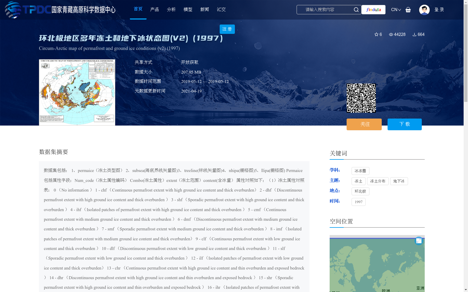
数据集包括: 1、permaice(冻土类型图) 2、subsea(海底界线矢量图)3、treeline(林线矢量图)4、nhipa(栅格图)5、llipa(栅格图)
Permaice包括属性字段:Num_code(冻土属性编码)
Combo(冻土属性)extent(冻土范围)content(含冰量)
属性对照如下:(1)冻土属性对照表:
0 (No information )
1 - chf (Continuous permafrost extent with high ground ice content and thick overburden)
2 - dhf (Discontinuous permafrost extent with high ground ice content and thick overburden )
3 - shf (Sporadic permafrost extent with high ground ice content and thick overburden )
4 - ihf (Isolated patches of permafrost extent with high ground ice content and thick overburden )
5 - cmf (Continuous permafrost extent with medium ground ice content and thick overburden )
6 - dmf (Discontinuous permafrost extent with medium ground ice content and thick overburden )
7 - smf (Sporadic permafrost extent with medium ground ice content and thick overburden )
8 - imf (Isolated patches of permafrost extent with medium ground ice content and thick overburden)
9 - clf (Continuous permafrost extent with low ground ice content and thick overburden )
10 - dlf (Discontinuous permafrost extent with low ground ice content and thick overburden )
11 - slf (Sporadic permafrost extent with low ground ice content and thick overburden )
12 - ilf (Isolated patches of permafrost extent with low ground ice content and thick overburden)
13 - chr (Continuous permafrost extent with high ground ice content and thin overburden and exposed bedrock )
14 - dhr (Discontinuous permafrost extent with high ground ice content and thin overburden and exposed bedrock )
15 - shr (Sporadic permafrost extent with high ground ice content and thin overburden and exposed bedrock )
16 - ihr (Isolated patches of permafrost extent with high ground ice content and thin overburden and exposed bedrock)
17 - clr (Continuous permafrost extent with low ground ice content and thin overburden and exposed bedrock )
18 - dlr (Discontinuous permafrost extent with low ground ice content and thin overburden and exposed bedrock )
19 - slr (Sporadic permafrost extent with low ground ice content and thin overburden and exposed bedrock)
20 - ilr (Isolated patches of permafrost extent with low ground ice content and thin overburden and exposed bedrock )
21 - g (Glaciers)
22 - r (Relict permafrost)
23 - l (Inland lakes )
24 - o (Ocean/inland seas )
25 - ld (Land)
(2)冻土范围对照表
c = continuous (90-100%)
d = discontinuous (50- 90%)
s = sporadic (10- 50%)
i = isolated patches ( 0 - 10%)
(3)含冰量对照表
h = high (>20% for "f" landform codes) (>10% for "r" landform codes)
m = medium (10-20%)
l = low (0-10%)
------------------------------------------------------------
Projection of the shapefiles is:
PROJCS["Sphere_ARC_INFO_Lambert_Azimuthal_Equal_Area",
GEOGCS["GCS_Sphere_ARC_INFO",
DATUM["Sphere_ARC_INFO", SPHEROID["Sphere_ARC_INFO",6370997.0,0.0]],
PRIMEM["Greenwich",0.0],
UNIT["Degree",0.0174532925199433]],
PROJECTION["Lambert_Azimuthal_Equal_Area"],
PARAMETER["False_Easting",0.0],
PARAMETER["False_Northing",0.0],
PARAMETER["longitude_of_center",180.0],
PARAMETER["latitude_of_center",90.0],
UNIT["Meter",1.0]]
Projection for the raster (*.byte) files is:
Projection: Lambert Azimuthal
Units: meters
Spheroid: defined
Major Axis: 6371228.00000
Minor Axis: 6371228.000
Parameters:
radius of the sphere of reference: 6371228.00000
longitude of center of projection: 0
latitude of center of projection: 90
false easting (meters): 0.00000
false northing (meters): 0.00000
本数据集包含以下地理要素图层:1、冻土类型图(permaice);2、海底界线矢量图(subsea);3、林线矢量图(treeline);4、栅格图(nhipa);5、栅格图(llipa)。
冻土类型图(permaice)的属性字段包括:Num_code(冻土属性编码)、Combo(冻土属性)、extent(冻土范围)、content(含冰量)。
属性对照说明如下:
(1)冻土属性对照表:
0:无信息(No information)
1 - chf:连续多年冻土区,地下冰含量高且覆盖层厚(Continuous permafrost extent with high ground ice content and thick overburden)
2 - dhf:不连续多年冻土区,地下冰含量高且覆盖层厚(Discontinuous permafrost extent with high ground ice content and thick overburden)
3 - shf:零星多年冻土区,地下冰含量高且覆盖层厚(Sporadic permafrost extent with high ground ice content and thick overburden)
4 - ihf:孤立斑块状多年冻土区,地下冰含量高且覆盖层厚(Isolated patches of permafrost extent with high ground ice content and thick overburden)
5 - cmf:连续多年冻土区,地下冰含量中等且覆盖层厚(Continuous permafrost extent with medium ground ice content and thick overburden)
6 - dmf:不连续多年冻土区,地下冰含量中等且覆盖层厚(Discontinuous permafrost extent with medium ground ice content and thick overburden)
7 - smf:零星多年冻土区,地下冰含量中等且覆盖层厚(Sporadic permafrost extent with medium ground ice content and thick overburden)
8 - imf:孤立斑块状多年冻土区,地下冰含量中等且覆盖层厚(Isolated patches of permafrost extent with medium ground ice content and thick overburden)
9 - clf:连续多年冻土区,地下冰含量低且覆盖层厚(Continuous permafrost extent with low ground ice content and thick overburden)
10 - dlf:不连续多年冻土区,地下冰含量低且覆盖层厚(Discontinuous permafrost extent with low ground ice content and thick overburden)
11 - slf:零星多年冻土区,地下冰含量低且覆盖层厚(Sporadic permafrost extent with low ground ice content and thick overburden)
12 - ilf:孤立斑块状多年冻土区,地下冰含量低且覆盖层厚(Isolated patches of permafrost extent with low ground ice content and thick overburden)
13 - chr:连续多年冻土区,地下冰含量高、覆盖层薄且基岩裸露(Continuous permafrost extent with high ground ice content and thin overburden and exposed bedrock)
14 - dhr:不连续多年冻土区,地下冰含量高、覆盖层薄且基岩裸露(Discontinuous permafrost extent with high ground ice content and thin overburden and exposed bedrock)
15 - shr:零星多年冻土区,地下冰含量高、覆盖层薄且基岩裸露(Sporadic permafrost extent with high ground ice content and thin overburden and exposed bedrock)
16 - ihr:孤立斑块状多年冻土区,地下冰含量高、覆盖层薄且基岩裸露(Isolated patches of permafrost extent with high ground ice content and thin overburden and exposed bedrock)
17 - clr:连续多年冻土区,地下冰含量低、覆盖层薄且基岩裸露(Continuous permafrost extent with low ground ice content and thin overburden and exposed bedrock)
18 - dlr:不连续多年冻土区,地下冰含量低、覆盖层薄且基岩裸露(Discontinuous permafrost extent with low ground ice content and thin overburden and exposed bedrock)
19 - slr:零星多年冻土区,地下冰含量低、覆盖层薄且基岩裸露(Sporadic permafrost extent with low ground ice content and thin overburden and exposed bedrock)
20 - ilr:孤立斑块状多年冻土区,地下冰含量低、覆盖层薄且基岩裸露(Isolated patches of permafrost extent with low ground ice content and thin overburden and exposed bedrock)
21 - g:冰川(Glaciers)
22 - r:残留多年冻土(Relict permafrost)
23 - l:内陆湖泊(Inland lakes)
24 - o:海洋/内陆海(Ocean/inland seas)
25 - ld:陆地(Land)
(2)冻土范围对照表:
c = 连续(覆盖占比90%-100%)
d = 不连续(覆盖占比50%-90%)
s = 零星(覆盖占比10%-50%)
i = 孤立斑块(覆盖占比0%-10%)
(3)含冰量对照表:
h = 高含量(针对“f”类地形编码,地下冰占比>20%;针对“r”类地形编码,地下冰占比>10%)
m = 中含量(地下冰占比10%-20%)
l = 低含量(地下冰占比0%-10%)
矢量Shapefile的投影定义如下:
PROJCS["Sphere_ARC_INFO_Lambert_Azimuthal_Equal_Area",
GEOGCS["GCS_Sphere_ARC_INFO",
DATUM["Sphere_ARC_INFO", SPHEROID["Sphere_ARC_INFO",6370997.0,0.0]],
PRIMEM["Greenwich",0.0],
UNIT["Degree",0.0174532925199433]],
PROJECTION["Lambert_Azimuthal_Equal_Area"],
PARAMETER["False_Easting",0.0],
PARAMETER["False_Northing",0.0],
PARAMETER["longitude_of_center",180.0],
PARAMETER["latitude_of_center",90.0],
UNIT["Meter",1.0]]
栅格(*.byte)文件的投影定义如下:
投影方式:兰伯特方位等面积投影
单位:米
参考椭球体:已定义
长半轴:6371228.00000米
短半轴:6371228.000米
投影参数:
参考球面半径:6371228.00000米
投影中心经度:0°
投影中心纬度:90°
伪东向偏移(米):0.00000
伪北向偏移(米):0.00000
提供机构:
O. Ferrians,J. A. Heginbottom,E. Melnikov,Tingjun Zhang,冉有华
创建时间:
2011-09-05
搜集汇总
数据集介绍
背景与挑战
背景概述
该数据集是环北极地区多年冻土和地下冰状态图(版本V2,参考时间1997年),包含冻土类型图、海底界线矢量图、林线矢量图及栅格图等文件,详细编码了冻土范围、含冰量和属性信息。数据大小为207.05 MB,采用开放获取共享方式,适用于冰冻圈科学中的冻土分布和地下冰研究,需遵循CC BY-NC-SA 4.0许可协议并正确引用相关文献。
以上内容由遇见数据集搜集并总结生成


