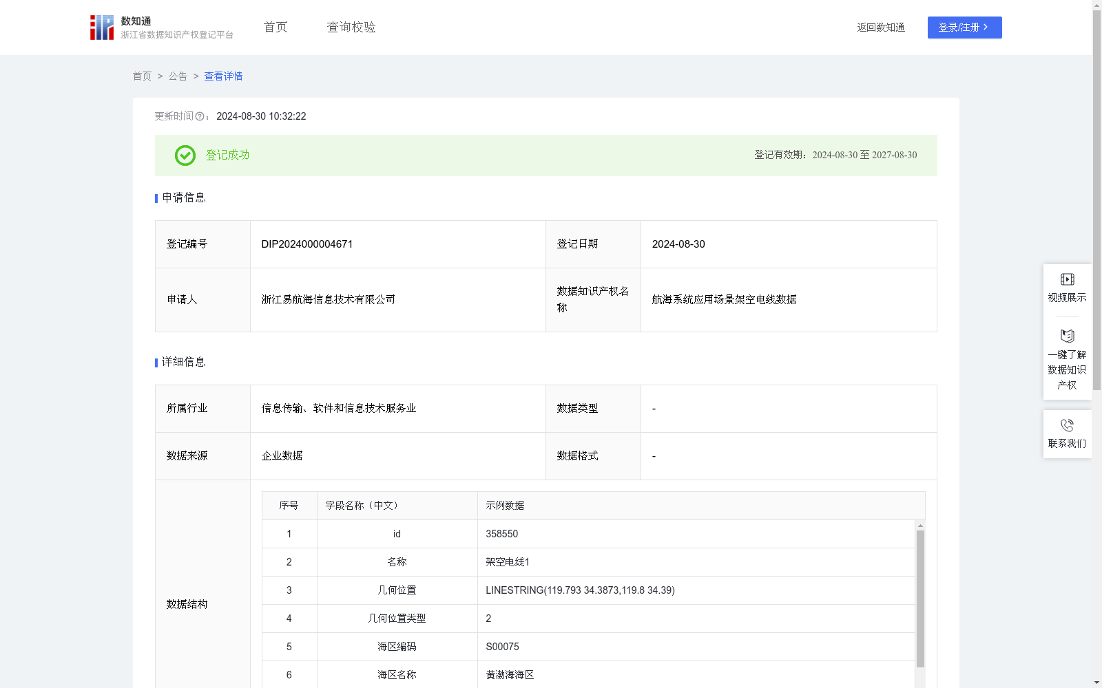
航海系统应用场景架空电线数据
收藏浙江省数据知识产权登记平台2024-08-30 更新2024-08-31 收录
下载链接:
https://www.zjip.org.cn/home/announce/trends/56281
下载链接
链接失效反馈官方服务:
资源简介:
架空电线是通过支柱或塔架支撑的电力输送或通信信号装置,通常横跨海峡、入海口或沿岸线。将架空电线以线形图形标注在电子海图上,有助于用户在电子海图中识别该区域。提醒船员在航行或停泊时注意电线的位置和高度,避免船舶的桅杆、天线等设备与电线发生碰撞。通过海事局公告、改正通告、航行通告、海图及航海图书资料等收集架空电线地理位置数据和内容,对原始地理位置数据进行可视化处理,数据存储为WKT格式。WKT格式由两部分组成,一部分描述空间几何对象的类型和坐标系信息(例:LINESTRING (x1 y1, x2 y2, ..., xn yn)),另一部分则是空间几何对象的坐标点的序列,系统通过坐标类型的枚举匹配识别出当前WKT的对象类型(几 何 位 置 类 型 点 1 、线 2 、 面 3 、 多点4 、 多 线为5 、多面为6),然后根据对象类型对其包含的空间信息进行二次处理,根据点、线、面、多线、多面等情况进行处理后生成经纬度列表数据。按照数据类型,记录相关属性至数据后台,在我司后台上进行点位绘制,绘制几何图形同步到电子海图中。高度判断:当船舶位于架空电线水域且处于运动状态时,通过用户在系统输入的船高与数据后台的架空电线高度数据进行智能对比,判断船舶能否通过架空电线水域。
Overhead power lines are power transmission or communication signal devices supported by poles or towers, which typically span straits, estuaries or coastal areas. Marking overhead power lines as linear graphics on electronic nautical charts helps users identify the relevant area within the charts. This also serves to remind seafarers to pay attention to the position and height of the lines during navigation or berthing, so as to prevent collisions between ship masts, antennas and other onboard equipment and the overhead power lines.
Geographic location data and relevant information of overhead power lines are collected via maritime administration notices, correction notices, Notices to Mariners, nautical charts and nautical publications. The original geographic location data is subjected to visualization processing, and the data is stored in Well-Known Text (WKT) format. The WKT format consists of two parts: one part describes the type of spatial geometric objects and coordinate system information (e.g., LINESTRING (x1 y1, x2 y2, ..., xn yn)), while the other part is the sequence of coordinate points of the spatial geometric objects. The system identifies the object type of the current WKT through enumeration matching of coordinate types (geometric position types: point 1, line 2, polygon 3, multi-point 4, multi-line 5, multi-polygon 6). It then performs secondary processing on the contained spatial information according to the object type, and generates longitude-latitude coordinate list data after processing based on the cases of point, line, polygon, multi-line and multi-polygon.
Relevant attributes are recorded into the company's data backend according to the data type, and point plotting is conducted on the company's backend. The drawn geometric graphics are synchronized to the electronic nautical charts.
Height judgment: When a ship is located in the waters with overhead power lines and is underway, the system intelligently compares the ship height input by the user in the system with the overhead power line height data stored in the data backend to determine whether the ship can safely pass through the waters with overhead power lines.
提供机构:
浙江易航海信息技术有限公司
创建时间:
2024-08-01
搜集汇总
数据集介绍
特点
航海系统应用场景架空电线数据集包含604条记录,每周更新,记录了架空电线的地理位置、类型、海区信息等,适用于电子海图中的架空电线标注和船舶航行安全提醒。数据来源于企业,格式为WKT,已在浙江省知识产权区块链公共存证平台存证。
以上内容由遇见数据集搜集并总结生成


