全球农田水分利用效率产品(2001-2020 年,1 公里分辨率) (GCWUE-1km_2001-2020)
收藏地球大数据科学工程2024-04-21 收录
下载链接:
https://data.casearth.cn/sdo/detail/641481ae819aec3f2b52b2cb
下载链接
链接失效反馈官方服务:
资源简介:
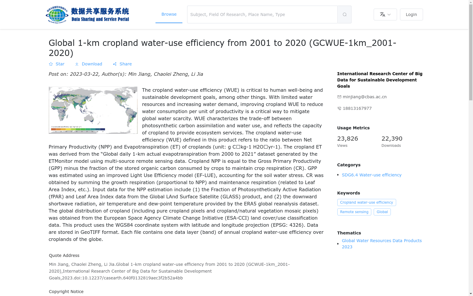
农田水分利用效率与人类福祉和可持续发展目标等息息相关,在水资源总量有限而用水需求不断增长的情况下,提高水分利用效率,减小单位生产力所需的耗水量,是解决水资源短缺问题的重要途径之一。
本数据产品定义的农田水分利用效率表达为农田净初级生产力与蒸散发量之间的比值(单位:克碳/千克水/年),表征了作物光合作用碳同化与水消耗之间的权衡关系,反映农田生态系统服务能力。农田蒸散发量来自本数据产品集中的“全球陆表蒸散发产品”,该数据产品由多源遥感数据等驱动的ETMonitor模型估算;农田净初级生产力等于作物总初级生产力减去作物维持自身呼吸所消耗的被固定的有机碳部分,其中,总初级生产力由考虑了土壤水分胁迫后改进的光能利用率模型EF-LUE估算,作物维持自身呼吸所消耗的被固定的有机碳部分则由生长呼吸(与净初级生产力成正比)和维持呼吸(与叶面积指数等有关) 累加获得。
估算农田净初级生产力的输入数据包括:(1)全球陆表特征参量产品(GLASS)的光合有效辐射比和叶面积指数数据;(2)欧洲中期天气预报中心ERA5全球大气再分析数据集提供的下行短波辐射、气温和露点温度等要素。农田分布(包含纯农田像元以及农田和自然植被混合像元)数据来自欧洲空间局气候变化倡议(ESA-CCI)的土地覆盖/利用分类数据。
本数据产品采用 WGS84 坐标系统和经纬度投影 (EPSG:4326),产品格式为GeoTIFF。
Farmland water use efficiency (WUE) is closely linked to human well-being and the Sustainable Development Goals (SDGs). Given the limited total water resources and ever-growing water demand, improving WUE and reducing water consumption per unit productivity is one of the important approaches to addressing water scarcity.
This data product defines farmland WUE as the ratio of farmland net primary productivity (NPP) to evapotranspiration (ET), with the unit of grams carbon per kilogram water per year. This metric characterizes the trade-off between carbon assimilation via crop photosynthesis and water consumption, reflecting the ecosystem service capacity of farmlands. Farmland ET data is sourced from the "Global Land Surface Evapotranspiration Product" in this dataset collection, which is estimated by the ETMonitor model driven by multi-source remote sensing data and other auxiliary datasets. Farmland NPP is calculated as crop gross primary productivity (GPP) minus the fixed organic carbon consumed by crops for their own respiratory maintenance. Specifically, GPP is estimated by the improved light use efficiency model EF-LUE that accounts for soil water stress, while the fixed organic carbon consumed by crop respiration for self-maintenance is derived as the sum of growth respiration (proportional to NPP) and maintenance respiration (related to leaf area index and other factors).
Input datasets for estimating farmland NPP include: (1) Fraction of Photosynthetically Active Radiation (FPAR) and Leaf Area Index (LAI) data from the Global Land Surface Characteristics Parameter Product (GLASS); (2) Downward shortwave radiation, air temperature, dew point temperature and other meteorological variables provided by the ERA5 global atmospheric reanalysis dataset from the European Centre for Medium-Range Weather Forecasts (ECMWF). Farmland distribution data (covering pure farmland pixels and mixed pixels of farmland and natural vegetation) is obtained from the Land Cover/Land Use Classification Data of the European Space Agency Climate Change Initiative (ESA-CCI).
This data product adopts the WGS84 coordinate system and geographic latitude-longitude projection (EPSG:4326), with the product format being GeoTIFF.
提供机构:
可持续发展大数据国际研究中心
搜集汇总
数据集介绍
背景与挑战
背景概述
该数据集是一个全球范围的农田水分利用效率产品,覆盖2001年至2020年,空间分辨率为1公里。它通过计算净初级生产力与蒸散发的比值来量化农田水分利用效率,数据基于多源遥感和再分析数据生成,以GeoTIFF格式提供年度图层,适用于水资源可持续性和农业生态系统研究。
以上内容由遇见数据集搜集并总结生成


