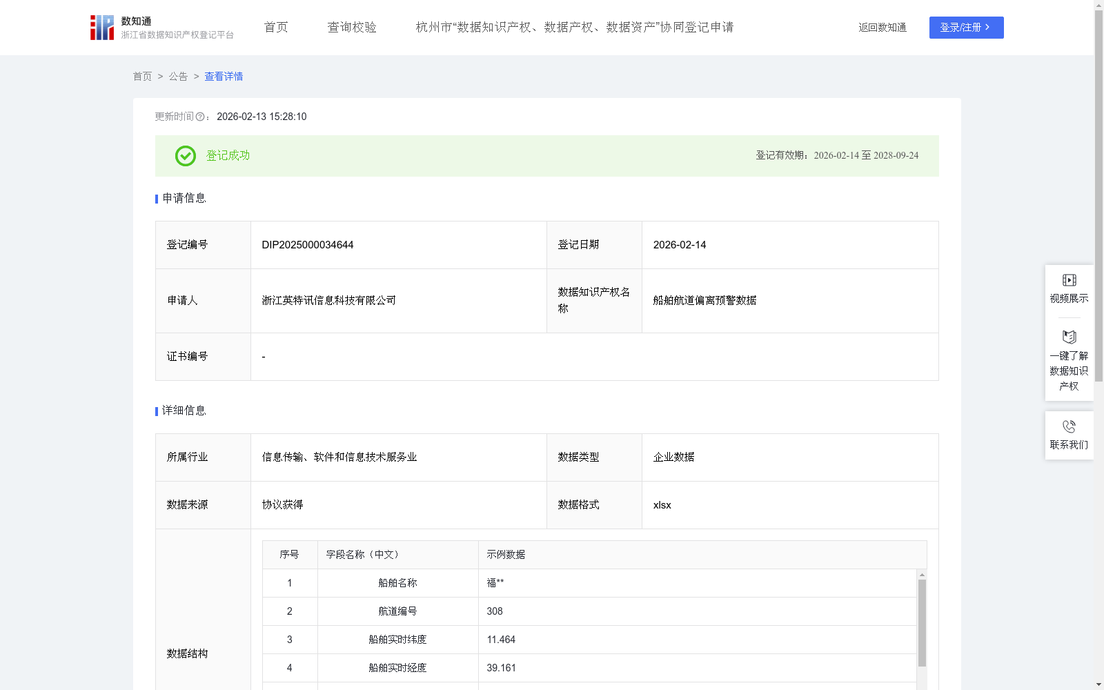
船舶航道偏离预警数据
收藏浙江省数据知识产权登记平台2026-02-13 更新2026-02-14 收录
下载链接:
https://www.zjip.org.cn/home/announce/trends/8428792
下载链接
链接失效反馈官方服务:
资源简介:
通过航道偏离预警系统实时采集船舶的实时经纬度、预设航道边界及航行轨迹数据,并自动归档至船舶数据中心。依托对这些数据的动态比对与趋势分析,为用户安全监控提供决策依据。通过实时位置与预设航道的偏差值变化,可精准监控船舶的航迹偏离程度,有助于评估船员航线保持能力及外部环境(如强流、大风)对航行的影响,尤其在雾天、夜间等低能见度工况下,用户能依据数据快速掌握船舶偏航风险等级,提前规避潜在危险。用户可提前设定不同航段的安全偏离阈值,若实时偏差超出阈值,系统立即触发预警,提示用户及时介入调整航向,避免船舶驶入禁航区、浅滩或与其他船舶形成碰撞风险。1、数据采集:通过在船舶上装载AIS / 北斗卫星设备、水文 / 气象传感器及状态监测模块,1 秒 / 条采集经纬度、航速、环境参数等数据,实时存储至船端设备。2、数据导入:船舶靠岸后,将船端设备连岸端内网,登录管理平台上传数据;平台自动校验(剔除异常值),按 “船舶 - 日期 - 航次” 分类存至数据库。3、预警模型训练:筛选不同航道 / 环境的航行样本,提取 “定位 - 边界 - 偏离 - 预警” 特征;导入 AI 平台标注预警标签,训练 5000 + 样本至准确率≥99.7%,部署至岸端。4、偏离预警识别:岸端平台实时接收数据,调用 AI 模型按 “预处理→算偏离→修阈值→判等级” 运算,返回 “预警等级、偏离距离、修正阈值、风险因子” 结果。5、数据应用:前端按预警等级响应(无预警展轨迹、一级弹提醒、二级报警);管理人员可查预警记录,点击跳转对应视频,快速回溯偏离过程。
This system collects real-time ship longitude and latitude, preset channel boundaries and navigation trajectory data in real time via the Course Deviation Warning System, and automatically archives them to the Ship Data Center. Based on dynamic comparison and trend analysis of these data, it provides decision-making support for users' safety monitoring. By tracking the deviation changes between the real-time position and the preset channel, it can accurately monitor the degree of ship track deviation, helping to evaluate the crew's ability to maintain the course and the impact of external environments such as strong currents and strong winds on navigation. Especially under low-visibility conditions such as foggy days and nights, users can quickly grasp the ship's drift risk level based on the data and avoid potential dangers in advance. Users can set safe deviation thresholds for different voyage segments in advance. If the real-time deviation exceeds the threshold, the system will immediately trigger an early warning to prompt users to intervene and adjust the course in time, preventing the ship from entering restricted navigation areas, shallow waters or forming collision risks with other ships.
1. Data Collection: Equipped with AIS/BeiDou Navigation Satellite System devices, hydrological and meteorological sensors and condition monitoring modules on the ship, it collects data such as longitude and latitude, ship speed and environmental parameters at a rate of 1 record per second, and stores them in the on-board equipment in real time.
2. Data Import: After the ship berths, connect the on-board equipment to the shore-side intranet and log in to the management platform to upload data; the platform automatically verifies (eliminates abnormal values) and stores them in the database classified by "ship - date - voyage".
3. Early Warning Model Training: Screen navigation samples of different channels and environments, extract the features of "positioning - boundary - deviation - early warning"; import them into the AI platform to label early warning tags, train more than 5000 samples until the accuracy reaches ≥99.7%, and deploy the model to the shore side.
4. Deviation Warning Recognition: The shore-side platform receives data in real time, calls the AI model to perform operations in the order of "preprocessing → calculate deviation → adjust threshold → judge level", and returns the results of "warning level, deviation distance, correction threshold, risk factor".
5. Data Application: The front end responds according to the warning level (displays trajectory without warning, pops up reminders for level 1, alarms for level 2); managers can check the warning records and click to jump to the corresponding video to quickly review the deviation process.
提供机构:
浙江英特讯信息科技有限公司
创建时间:
2025-11-21
搜集汇总
数据集介绍
背景与挑战
背景概述
该数据集包含822条船舶航行记录,每季度更新,涵盖船舶名称、实时位置、航速、航道基准线及偏离距离等关键字段,专门用于监控船舶航道偏离情况。通过AI模型实时分析位置数据与预设航道的偏差,系统能自动触发预警等级,帮助用户评估航行风险并提前规避碰撞、浅滩等危险。其应用场景聚焦于低能见度环境下的安全监控,为船舶航行管理提供数据驱动的决策依据。
以上内容由遇见数据集搜集并总结生成


