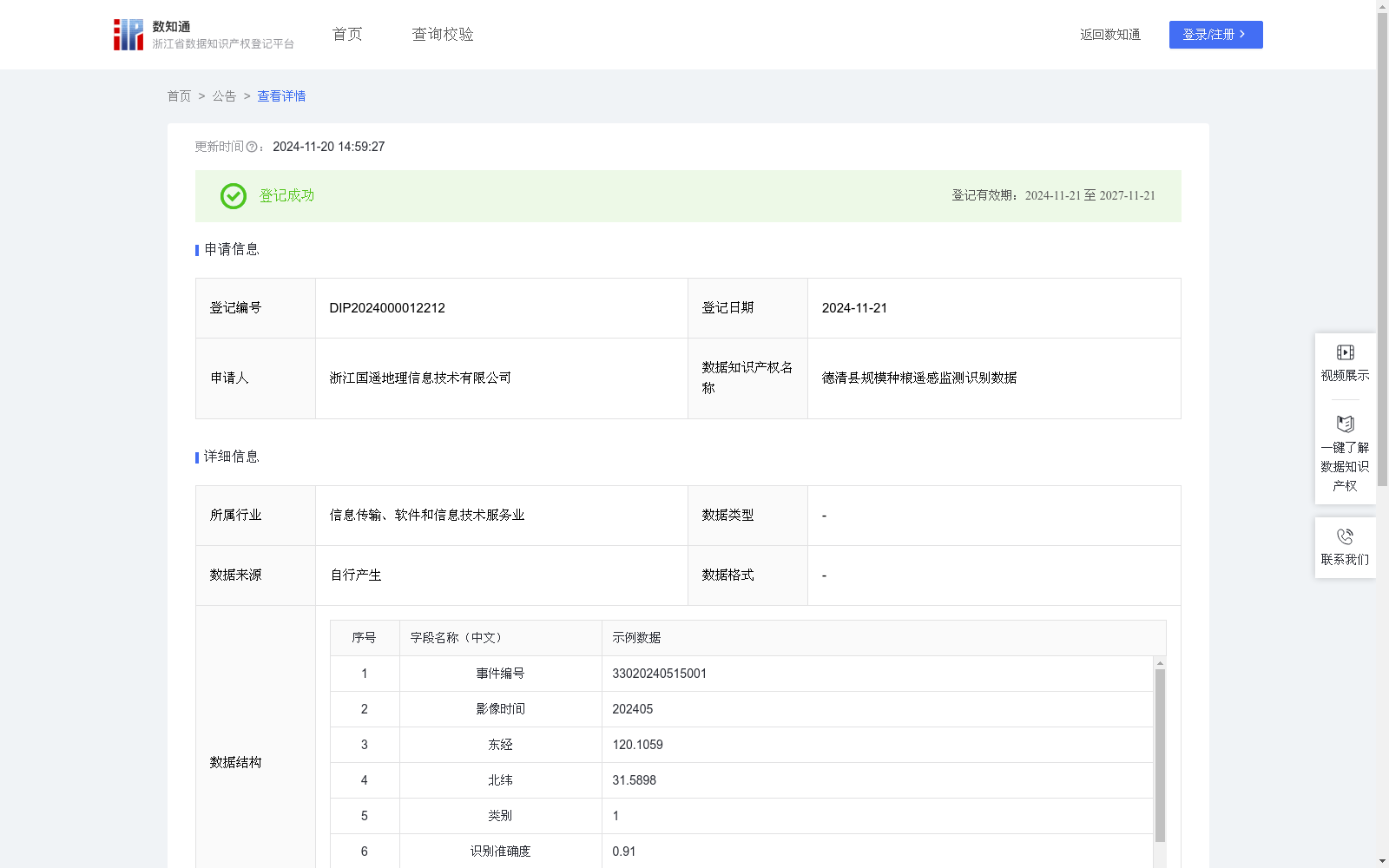
德清县规模种粮遥感监测识别数据
收藏浙江省数据知识产权登记平台2024-11-20 更新2024-11-21 收录
下载链接:
https://www.zjip.org.cn/home/announce/trends/86984
下载链接
链接失效反馈官方服务:
资源简介:
用于实现对粮食补贴中农田地块位置、作物种类的高效精准识别。自动识别遥感影像中规模种粮地块的坐标,便于确定地块位置与分布,为后续种粮地块确权与种粮补贴发放提供基础。依据算法自动对作物进行分类并验证,得到作物类型并确认识别正确,实现自动识别与智能分类,大大减少人工实地核查与目视解译的时间。规模种粮遥感监测识别数据录入系统中,实现数据可视化。为工作人员开展种粮补贴工作提供客观公正的基础数据,从源头上堵塞虚报漏洞,让惠农补贴真正落到实处。基于无人机航拍采集2024年5月的农田环境遥感影像数据,通过YOLO算法进行目标检测,识别出粮食作物区域。首先,将单元神经网络应用于完整的遥感影像,将图像将图像分割成19x19的单元格,每个单元神经网络负责预测K个单元格。预测每个区域的概率,所有单元格上具有最大概率的类被选择并分配给特定的网格单元,生成区域中心坐标(x,y),采用CGCS2000坐标系,坐标默认东经、北纬。在预测类概率后,进行NMS运算,消除不必要的锚点。抽取验证样本计算识别准确度,越接近1表示越准确,高于0.6表示识别正确,低于0.6表示识别错误。依据识别准确度,判定目标是否为农田。在农田地块中,算法依据样本库自动生成类别,并匹配到当前项目识别类别:油菜、小麦、水稻、其他。对识别正确的油菜、小麦、水稻地块目标进行纳入操作,对识别错误的非农田、其他类别地块进行排除操作。最后将纳入的坐标、识别类别等数据自动上传至德清县粮补平台,最终获得德清县规模种粮遥感监测识别数据。
This dataset is developed for efficient and accurate identification of farmland plot locations and crop types in the context of grain subsidies. It automatically identifies the coordinates of large-scale grain-growing plots in remote sensing images, enabling confirmation of plot locations and distributions, and providing a fundamental basis for subsequent confirmation of grain-growing plot rights and the distribution of grain subsidies. The system automatically classifies and verifies crops, obtains crop types and validates the recognition accuracy, realizing automatic identification and intelligent classification, which significantly reduces the time required for manual on-site verification and visual interpretation. The remote sensing monitoring and identification data of large-scale grain-growing plots are imported into the system to achieve data visualization, providing objective and fair basic data for staff to carry out grain subsidy work, plugging false reporting loopholes at the source, and ensuring that agricultural subsidies are truly implemented as intended. Based on remote sensing image data of farmland environments collected via UAV aerial photography in May 2024, the YOLO algorithm is employed for target detection to identify grain crop areas. First, a grid-based neural network is applied to the complete remote sensing image, dividing the image into 19x19 grid cells. Each grid cell is responsible for predicting K bounding boxes. The confidence probability of each region is predicted, and the class with the highest probability across all predictions is selected and assigned to the corresponding grid cell, generating the regional center coordinates (x, y). The CGCS2000 coordinate system is adopted, with coordinates defaulting to east longitude and north latitude. After predicting the class probabilities, Non-Maximum Suppression (NMS) is performed to eliminate redundant anchor boxes. Validation samples are extracted to calculate the recognition accuracy, where a value closer to 1 indicates higher accuracy. A score higher than 0.6 denotes correct recognition, while a score lower than 0.6 indicates incorrect recognition. Whether the target is farmland is determined based on the recognition accuracy. Within farmland plots, the algorithm automatically generates categories based on the sample database and matches them to the recognition categories of this project: rapeseed, wheat, rice, and others. Targets of correctly identified rapeseed, wheat, and rice plots are included, while incorrectly identified non-farmland and other category plots are excluded. Finally, the included coordinates, recognition categories and other relevant data are automatically uploaded to the Deqing County Grain Subsidy Platform, and the remote sensing monitoring and identification data of large-scale grain-growing plots in Deqing County are finally obtained.
提供机构:
浙江国遥地理信息技术有限公司
创建时间:
2024-10-21
搜集汇总
数据集介绍
以上内容由遇见数据集搜集并总结生成


