塔吉克斯坦不同重现期极端降水-滑坡灾害综合危险性数据集
收藏国家青藏高原科学数据中心2025-07-14 更新2025-07-26 收录
下载链接:
https://data.tpdc.ac.cn/zh-hans/data/e940b2cb-5fd4-4fcb-a7fa-fd5bc39e7a4d
下载链接
链接失效反馈官方服务:
资源简介:
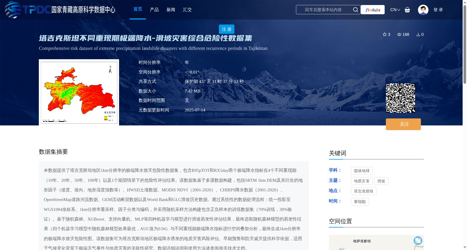
本数据提供了塔吉克斯坦地区1km分辨率的极端降水致灾危险性数据集,包含R95pTOT和RX5day两个极端降水指标在4个不同重现期(10年、20年、50年、100年)以及1个期望情景下的危险性评估结果。该数据集基于多源数据构建,包括SRTM 1km DEM及其衍生的地形因子(坡度、坡向、地形湿度指数等)、HWSD土壤数据、MODIS NDVI(2001-2020)、CHIRPS降水数据(2001-2020)、OpenStreetMap道路河流数据、GEM活动断层数据以及World Bank和GLC滑坡历史数据。通过系统性的数据处理流程:统一投影至WGS1984坐标系、1km分辨率重采样、因子分类与编码,并采用随机采样方法构建包含正负样本的训练数据集(70%训练,30%验证)。基于随机森林、XGBoost、支持向量机、MLP等四种机器学习模型进行滑坡易发性评估结果,最终选取随机森林模型的易发性结果(四个机器学习模型中随机森林模型效果最优,AUC值为0.94)与不同重现期极端降水指标进行空间叠加分析,最终生成1km分辨率的极端降水致灾危险性图。该数据集可为塔吉克斯坦地区极端降水诱发的地质灾害风险评估、早期预警和防灾减灾提供科学依据,适用于气候变化背景下极端天气事件与地质灾害的关联性研究。数据详细说明和使用方法请参阅相关技术文档。
This dataset provides a 1 km-resolution extreme precipitation-induced disaster hazard dataset for Tajikistan. It includes hazard assessment results of two extreme precipitation indices, R95pTOT and RX5day, under four different return periods (10-year, 20-year, 50-year, 100-year) and one expected scenario. This dataset is constructed based on multi-source data, including SRTM 1 km DEM and its derived terrain factors (slope, aspect, topographic wetness index, etc.), HWSD soil data, MODIS NDVI (2001–2020), CHIRPS precipitation data (2001–2020), OpenStreetMap road and river data, GEM active fault data, as well as World Bank and GLC landslide historical data. Through a systematic data processing workflow: unifying the projection to the WGS 1984 coordinate system, resampling to 1 km resolution, factor classification and coding, and using random sampling methods to construct a training dataset with positive and negative samples (70% for training, 30% for validation). Four machine learning models, namely Random Forest, XGBoost, Support Vector Machine (SVM), and Multi-Layer Perceptron (MLP), were used to conduct landslide susceptibility assessments. Finally, the susceptibility results from the Random Forest model (which achieved the best performance among the four models with an AUC value of 0.94) were selected for spatial overlay analysis with extreme precipitation indices under different return periods, ultimately generating the 1 km-resolution extreme precipitation-induced disaster hazard map. This dataset can provide scientific basis for risk assessment, early warning, disaster prevention and mitigation of geological disasters induced by extreme precipitation in Tajikistan, and is applicable to studies on the correlation between extreme weather events and geological disasters under the background of climate change. Please refer to the relevant technical documentation for detailed data descriptions and usage instructions.
提供机构:
程传美,郭浩,伍永秋,贾佳
创建时间:
2025-07-10
搜集汇总
数据集介绍
背景与挑战
背景概述
该数据集提供了塔吉克斯坦地区1km分辨率的极端降水-滑坡灾害综合危险性评估,包含R95pTOT和RX5day两个极端降水指标在10年、20年、50年、100年重现期及期望情景下的危险性图。数据集基于多源地理数据和机器学习模型(如随机森林,AUC值0.94)构建,旨在支持地质灾害风险评估、早期预警和气候变化相关研究。
以上内容由遇见数据集搜集并总结生成


