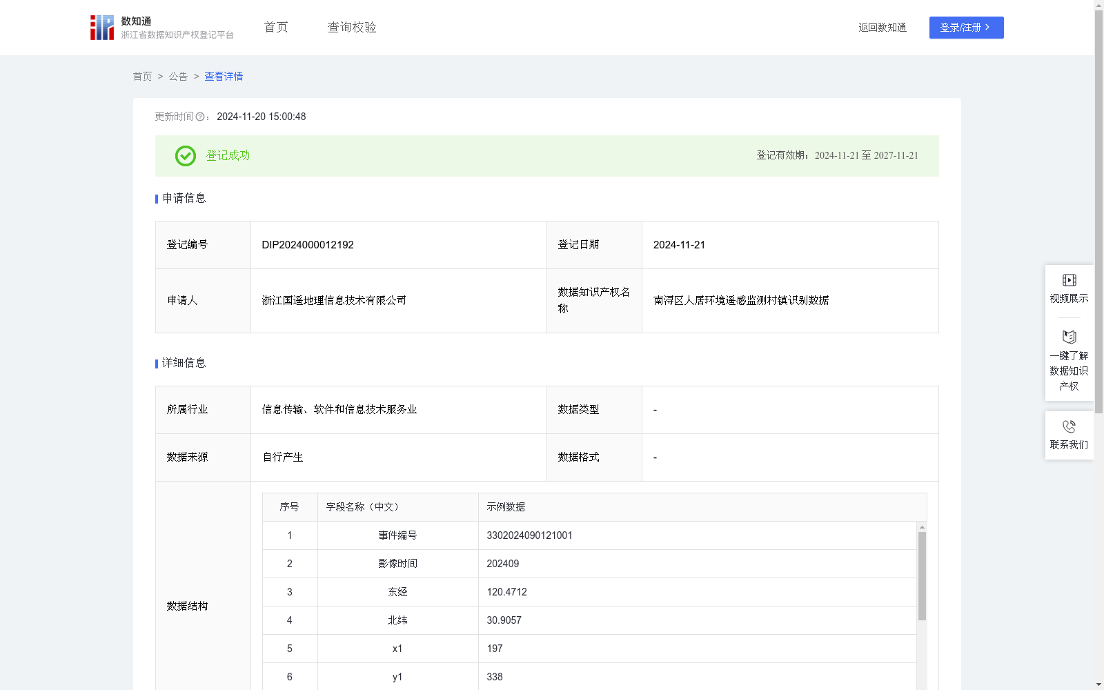
南浔区人居环境遥感监测村镇识别数据
收藏浙江省数据知识产权登记平台2024-11-20 更新2024-11-21 收录
下载链接:
https://www.zjip.org.cn/home/announce/trends/86988
下载链接
链接失效反馈官方服务:
资源简介:
用于实现对南浔区人居环境遥感监测中每一个人居环境问题点位的所属村镇,实现问题区域具体位置的高效精准识别。能够自动识别人居环境点位具体位置的坐标,便于确定需要进行实地核查的位置。自动匹配到村镇级行政区划,为后续进行现场处置工作提供方便,有利于上级管理人员及时掌握自己管理区域的情况。同时解决了人居环境工作人员不了解问题点位的具体位置与分布范围、难以将问题点位信息依据村镇进行统计归纳等问题。便于政府部门对南浔区人居环境的监督与处理等工作进行系统性的管理,减少时间损耗,降低人力成本,有利于推进人居环境监管处置的现代化发展。根据2024年9月南浔区人居环境问题点位的经纬度坐标以及镇街、村社区的行政区划边界矢量数据,进行空间包含关系的计算,对要素的坐标进行空间分析。通过在人居环境识别过程中生成地块的四个顶点坐标(x1,y1),(x2,y2),(x3,y3),(x4,y4),得到该区域在当前识别边界框中的相对位置,将其通过坐标转换,赋予实际地理坐标。由四个顶点实际地理坐标计算匹配到点位中心坐标(x,y),x为东经,y为北纬,与识别点位坐标相关联。将实际地理坐标与行政区划边界进行比较,判断要素是否位于某个行政区划的内部,如果不是,则判定下一个行政区划边界,最终确定该人居环境问题区域所属的镇、村级行政区划。
This dataset aims to efficiently and accurately identify the specific location of each problematic human settlements environment point in the remote sensing monitoring of the human settlements environment in Nanxun District, as well as determine the town and village-level administrative division that each point belongs to. It can automatically recognize the coordinates of the specific location of the human settlements environment points, facilitating the confirmation of locations requiring on-site verification. It also automatically matches these points to village and town-level administrative divisions, providing convenience for subsequent on-site disposal operations and enabling superior managers to timely grasp the situation within their respective management areas. Additionally, it resolves the common challenges faced by human settlements environment staff, including lacking awareness of the specific locations and distribution ranges of problematic points, and difficulty in statistically summarizing problematic point information according to towns and villages. It facilitates the systematic management of government departments' supervision and disposal work for the human settlements environment in Nanxun District, reduces time consumption and labor costs, and promotes the modernization of human settlements environment supervision and disposal. Based on the longitude and latitude coordinates of the problematic human settlements environment points in Nanxun District and the vector data of administrative division boundaries of towns, subdistricts, villages and communities as of September 2024, spatial inclusion relationship calculations are conducted to perform spatial analysis on the coordinates of the relevant elements. During the human settlements environment recognition process, four vertex coordinates (x1,y1), (x2,y2), (x3,y3), (x4,y4) of the target plot are generated to obtain the relative position of the area within the current bounding box. These relative coordinates are then converted into actual geographic coordinates via coordinate transformation. The central coordinate (x, y) of the point is calculated from the actual geographic coordinates of the four vertices, where x denotes east longitude and y denotes north latitude, and this central coordinate is associated with the coordinates of the recognized point. The actual geographic coordinates are then compared with the administrative division boundaries to determine whether the element falls within a certain administrative division. If not, the next administrative division boundary is checked, and finally the town and village-level administrative divisions to which the problematic human settlements environment area belongs are confirmed.
提供机构:
浙江国遥地理信息技术有限公司
创建时间:
2024-10-21
搜集汇总
数据集介绍
特点
该数据集包含529条记录,每季度更新,用于南浔区人居环境遥感监测中的村镇识别。通过遥感影像和地理坐标数据,结合行政区划边界,实现对人居环境问题点位的精准识别和定位,便于政府部门进行监督和管理。
以上内容由遇见数据集搜集并总结生成


