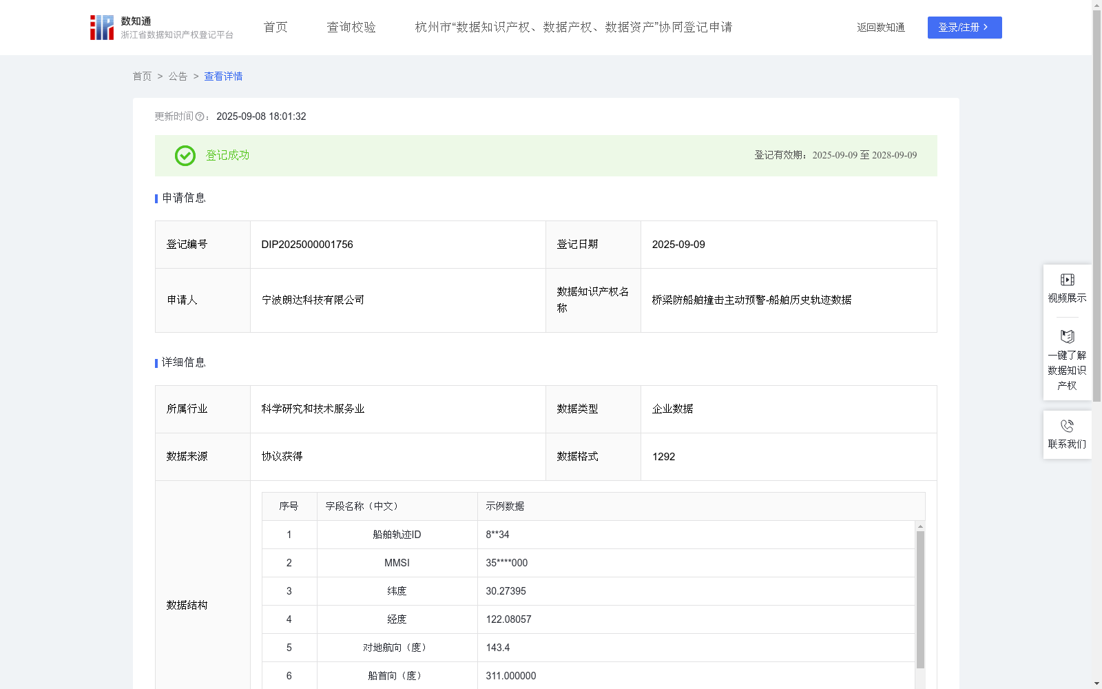
桥梁防船舶撞击主动预警-船舶历史轨迹数据
收藏浙江省数据知识产权登记平台2025-09-08 更新2025-09-09 收录
下载链接:
https://www.zjip.org.cn/home/announce/trends/176897
下载链接
链接失效反馈官方服务:
资源简介:
桥梁防船舶撞击主动预警-船舶历史轨迹数据在桥梁安全运行过程中扮演着重要角色,尤其在建设设计模拟、预防和日常维护中至关重要。通过持续监测,测量收集船舶轨迹id、mmsi、纬度 经度、对地航向(度)、船首向(度)、对地航速(节)、创建时间、更新时间的数据。可以根据船舶的历史轨迹数据,使用建立的船舶轨迹预测模型,可以对船舶未来一定时间内的运动方向、位置进行预测,从而判断船舶航线是否异常,一旦船舶偏航及时发出预警,避免船舶撞击桥梁事故的发生。船舶历史轨迹数据可以模拟对桥梁在不同船舶行驶轨迹和环境条件下的状态进行数据分析,模拟判断船舶是否满足安全运行要求,为船舶设计和建筑设计提供参考依据。 1、数据采集:将微波雷达探测到的船舶动态数据与船舶AIS信息进行融合,获得船舶的实时位置(纬度、经度)、对地航向、船首向、对地航速等时间序列数据。2、数据计算:首先对敏感信息进行加密处理,对数据进行加工、脱敏、筛选。(1)、使用双向长短期记忆网络(BiLSTM)算法建立船舶轨迹预测模型,采用贝叶斯优化(Bayesian Optimization,BO)对建立的轨迹预测模型进行优化。根据船舶的历史轨迹数据,代入纬度、经度、对地航向、船首向、对地航速,对船舶未来一定时间内的运动方向、位置进行预测,从而判断船舶航线是否异常,一旦船舶偏航及时发出预警,避免船舶撞击桥梁事故的发生。(2)、对海域内船舶的历史轨迹数据进行统计分析,实现航道的船舶交通流分析及预测,为航道的管理与决策提供依据。
Active Early Warning Against Ship Collision with Bridges - Historical ship trajectory data plays a critical role in the safe operation of bridges, and is particularly vital for construction design simulation, accident prevention, and daily maintenance. Through continuous monitoring, data including ship trajectory ID, MMSI, latitude, longitude, course over ground (degrees), ship heading (degrees), speed over ground (knots), creation time, and update time are collected and measured. Based on historical ship trajectory data, the established ship trajectory prediction model can forecast the movement direction and position of the ship within a certain future period, thereby determining whether the ship's route is abnormal. Once the ship deviates from the course, an early warning will be issued promptly to avoid ship-bridge collision accidents. Historical ship trajectory data can be used to simulate and analyze the state of bridges under different ship sailing trajectories and environmental conditions, evaluate whether ships meet safe operation requirements, and provide reference for ship design and bridge construction design.
1. Data Collection: Dynamical ship data detected by microwave radars is fused with ship Automatic Identification System (AIS) information to obtain time-series data including the ship's real-time position (latitude, longitude), course over ground, ship heading, speed over ground, etc.
2. Data Calculation: Sensitive information is first encrypted, and the data is processed, desensitized, and filtered.
(1) A ship trajectory prediction model is established using the Bidirectional Long Short-Term Memory (BiLSTM) algorithm, and the established trajectory prediction model is optimized via Bayesian Optimization (BO). Based on historical ship trajectory data, inputs including latitude, longitude, course over ground, ship heading, and speed over ground are used to forecast the movement direction and position of the ship within a certain future period, so as to determine whether the ship's route is abnormal. Once the ship deviates from its intended course, an early warning will be issued in a timely manner to prevent ship-bridge collision accidents.
(2) Statistical analysis is conducted on historical ship trajectory data within the sea area, to realize the analysis and prediction of ship traffic flow in the waterway, providing a basis for waterway management and decision-making.
提供机构:
宁波朗达科技有限公司
创建时间:
2025-03-29
搜集汇总
数据集介绍
背景与挑战
背景概述
该数据集包含1292条船舶历史轨迹记录,每月更新,涵盖经纬度、航向和航速等关键字段,用于桥梁防撞主动预警。通过BiLSTM算法进行轨迹预测和异常检测,有效预防船舶撞击事故,支持航道管理和安全决策。
以上内容由遇见数据集搜集并总结生成


