全球1公里分辨率地表土壤水分数据集(2000-2020)
收藏国家青藏高原科学数据中心2023-07-01 更新2024-03-01 收录
下载链接:
https://data.tpdc.ac.cn/zh-hans/data/30131436-88d1-4be3-8e3d-14905a29d6d6
下载链接
链接失效反馈官方服务:
资源简介:
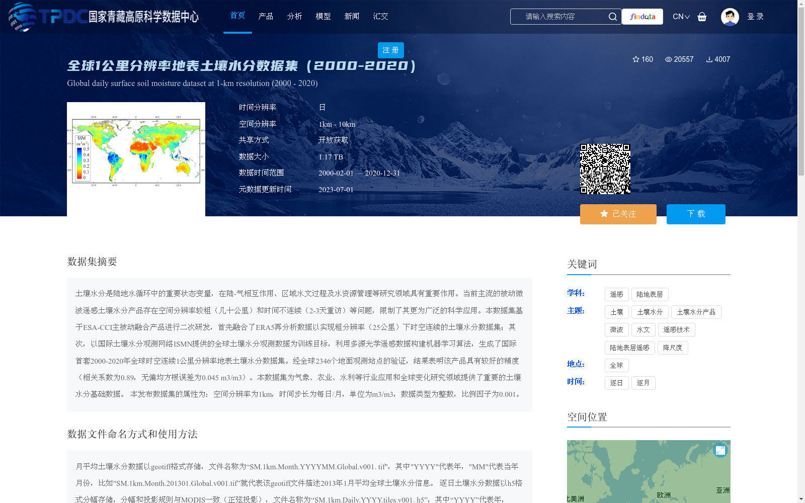
土壤水分是陆地水循环中的重要状态变量,在陆-气相互作用、区域水文过程及水资源管理等研究领域具有重要作用。当前主流的被动微波遥感土壤水分产品存在空间分辨率较粗(几十公里)和时间不连续(2-3天重访)等问题,限制了其更为广泛的科学应用。本数据集基于ESA-CCI主被动融合产品进行二次研发,首先融合了ERA5再分析数据以实现粗分辨率(25公里)下时空连续的土壤水分数据集;其次,以国际土壤水分观测网络ISMN提供的全球土壤水分观测数据为训练目标,利用多源光学遥感数据构建机器学习算法,生成了国际首套2000-2020年全球时空连续1公里分辨率地表土壤水分数据集。经全球2346个地面观测站点的验证,结果表明该产品具有较好的精度(相关系数为0.89,无偏均方根误差为0.045 m3/m3)。本数据集为气象、农业、水利等行业应用和全球变化研究领域提供了重要的土壤水分基础数据。
本发布数据集的属性为:空间分辨率为1km,时间步长为每日/月,单位为m3/m3,数据类型为整数,比例因子为0.001。
Soil moisture is a critical state variable in the terrestrial water cycle, and plays a vital role in research fields such as land-atmosphere interaction, regional hydrological processes, and water resource management. Current mainstream passive microwave remote sensing soil moisture products have limitations including coarse spatial resolution (tens of kilometers) and discontinuous temporal coverage (2-3 day revisit cycle), which restrict their broader scientific applications. This dataset is secondarily developed based on the ESA-CCI active-passive merged product. First, ERA5 reanalysis data is fused to construct a spatially and temporally continuous soil moisture dataset at a coarse resolution (25 km); second, using global soil moisture observation data from the International Soil Moisture Network (ISMN) as training targets, a machine learning algorithm is built with multi-source optical remote sensing data, generating the world's first global spatially and temporally continuous surface soil moisture dataset with 1 km spatial resolution spanning 2000 to 2020. Validated against 2346 global ground observation sites, the results demonstrate that this product has excellent accuracy, with a correlation coefficient of 0.89 and an unbiased root mean square error (ubRMSE) of 0.045 m³/m³. This dataset provides essential foundational soil moisture data for applications in meteorology, agriculture, water conservancy, and other sectors, as well as for global change research. Attributes of this released dataset are as follows: spatial resolution is 1 km, temporal resolution is daily/monthly, unit is m³/m³, data type is integer, and scale factor is 0.001.
提供机构:
郑超磊,贾立,赵天杰
创建时间:
2022-05-21
搜集汇总
数据集介绍
背景与挑战
背景概述
该数据集是全球首套2000-2020年时空连续的1公里分辨率地表土壤水分数据,基于ESA-CCI产品和ERA5再分析数据,通过机器学习算法融合多源遥感数据生成,经全球2346个站点验证具有高精度(相关系数0.89)。它提供每日和月平均土壤水分信息,以geotiff和h5格式存储,适用于气象、农业和水文等领域的应用,为全球变化研究提供了重要基础数据。
以上内容由遇见数据集搜集并总结生成


