基于多源数据与丰富样本标注的蒙古高原30米长期土地覆盖数据集(1990-2020年)
收藏国家地球系统科学数据中心2026-03-30 更新2025-12-20 收录
下载链接:
https://www.geodata.cn/data/datadetails.html?dataguid=245847258535233&docId=9
下载链接
链接失效反馈官方服务:
资源简介:
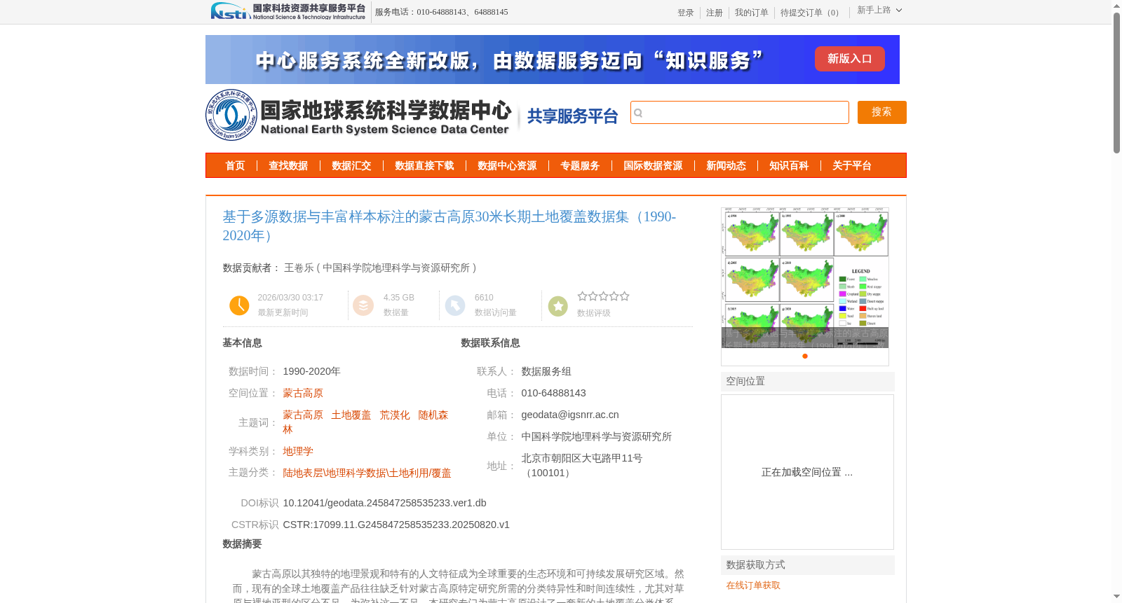
蒙古高原以其独特的地理景观和特有的人文特征成为全球重要的生态环境和可持续发展研究区域。然而,现有的全球土地覆盖产品往往缺乏针对蒙古高原特定研究所需的分类特异性和时间连续性,尤其对草原与裸地亚型的区分不足。为弥补这一不足,本研究专门为蒙古高原设计了一套新的土地覆盖分类体系,包含14个类别:森林(1)、灌木(2)、草甸(3)、典型草地(4)、干旱草地(5)、荒漠草地(6)、湿地(7)、水体(8)、农田(9)、建成区(10)、裸地(11)、沙漠(12)、沙地(13)和冰雪(14)。该数据集覆盖1990至2020年。研究采用机器学习与云计算技术,运用随机森林算法整合训练样本与多源特征进行土地覆盖分类,并实施两步随机森林分类策略以优化过渡地带的精细土地覆盖结果。研究在网格框架内精确标注了64345个样本点。最终生成的土地覆盖产品总体准确率达到83.6%。该土地覆盖产品及其开发方法在广阔的干旱与半干旱区域具有重要的应用潜力。
The Mongolian Plateau, distinguished by its unique geographical landscapes and distinctive human characteristics, is a globally significant research area for ecological environment and sustainable development studies. However, existing global land cover products often lack the classification specificity and temporal continuity required for targeted research on the Mongolian Plateau, particularly in distinguishing between grassland and bare land subtypes. To address this gap, this study developed a new land cover classification system specifically for the Mongolian Plateau, which includes 14 categories: Forest (1), Shrub (2), Meadow (3), Typical Grassland (4), Arid Grassland (5), Desert Grassland (6), Wetland (7), Water Body (8), Cropland (9), Built-up Area (10), Bare Land (11), Desert (12), Sandy Land (13), and Snow and Ice (14). This dataset covers the period from 1990 to 2020. This study adopted machine learning and cloud computing technologies, using the Random Forest algorithm to integrate training samples and multi-source features for land cover classification, and implemented a two-step Random Forest classification strategy to optimize fine-scale land cover results in transition zones. A total of 64,345 sample points were accurately annotated within a grid framework for this study. The overall accuracy of the finally generated land cover product reached 83.6%. This land cover product and its development method have important application potential in vast arid and semi-arid regions.
提供机构:
中国科学院地理科学与资源研究所
创建时间:
2025-08-20
搜集汇总
数据集介绍
背景与挑战
背景概述
该数据集是蒙古高原1990至2020年的30米分辨率长期土地覆盖产品,专门设计了包含14个类别的分类体系(如森林、草地、沙漠等),以弥补全球产品在区域特异性和时间连续性上的不足。它基于多源遥感数据和64345个精确标注样本,采用两步随机森林分类方法生成,总体准确率达83.6%,适用于干旱半干旱区域的生态环境和可持续发展研究。
以上内容由遇见数据集搜集并总结生成


