喜马拉雅山区30m土地覆盖(2020)
收藏国家青藏高原科学数据中心2023-02-24 更新2024-03-06 收录
下载链接:
https://data.tpdc.ac.cn/zh-hans/data/b539225c-17b6-4059-b145-ce39cf2d3b58
下载链接
链接失效反馈官方服务:
资源简介:
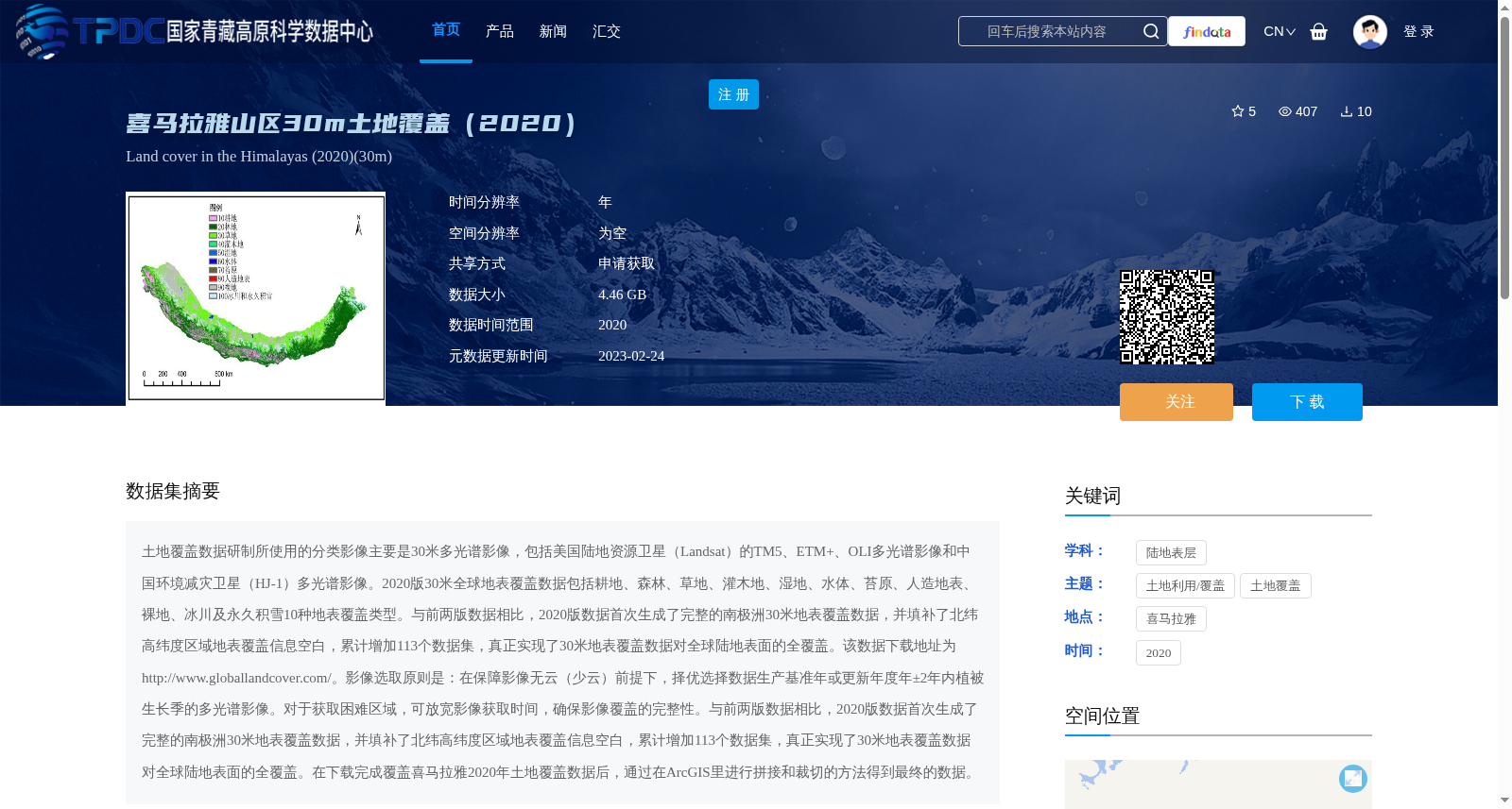
土地覆盖数据研制所使用的分类影像主要是30米多光谱影像,包括美国陆地资源卫星(Landsat)的TM5、ETM+、OLI多光谱影像和中国环境减灾卫星(HJ-1)多光谱影像。2020版30米全球地表覆盖数据包括耕地、森林、草地、灌木地、湿地、水体、苔原、人造地表、裸地、冰川及永久积雪10种地表覆盖类型。与前两版数据相比,2020版数据首次生成了完整的南极洲30米地表覆盖数据,并填补了北纬高纬度区域地表覆盖信息空白,累计增加113个数据集,真正实现了30米地表覆盖数据对全球陆地表面的全覆盖。该数据下载地址为http://www.globallandcover.com/。影像选取原则是:在保障影像无云(少云)前提下,择优选择数据生产基准年或更新年度年±2年内植被生长季的多光谱影像。对于获取困难区域,可放宽影像获取时间,确保影像覆盖的完整性。与前两版数据相比,2020版数据首次生成了完整的南极洲30米地表覆盖数据,并填补了北纬高纬度区域地表覆盖信息空白,累计增加113个数据集,真正实现了30米地表覆盖数据对全球陆地表面的全覆盖。在下载完成覆盖喜马拉雅2020年土地覆盖数据后,通过在ArcGIS里进行拼接和裁切的方法得到最终的数据。
The classified imagery used for developing land cover datasets is primarily 30-meter multispectral imagery, including TM5, ETM+, and OLI multispectral imagery from the U.S. Landsat program, as well as multispectral imagery from China's Environmental Disaster Reduction Satellite (HJ-1). The 2020 version of the 30-meter global land cover dataset includes 10 land cover types: cropland, forest, grassland, shrubland, wetland, water body, tundra, artificial surfaces, bare land, and glaciers and permanent snow cover. Compared with the previous two versions, the 2020 dataset generated the first complete 30-meter land cover dataset for Antarctica for the first time, filled the gap in land cover information for high-latitude regions north of the equator, and added a total of 113 datasets, truly achieving full coverage of the global land surface with 30-meter land cover data. The download address for this dataset is http://www.globallandcover.com/. The principle for selecting imagery is as follows: on the premise of ensuring cloud-free (or cloud-light) imagery, preferentially select multispectral imagery from the vegetation growing season within ±2 years of the data production baseline year or the update year. For regions where imagery acquisition is difficult, the image acquisition time window can be relaxed to ensure the completeness of imagery coverage. Compared with the previous two versions, the 2020 dataset generated the first complete 30-meter land cover dataset for Antarctica for the first time, filled the gap in land cover information for high-latitude regions north of the equator, and added a total of 113 datasets, truly achieving full coverage of the global land surface with 30-meter land cover data. After downloading the 2020 land cover data covering the Himalayas, the final dataset was obtained through mosaicking and clipping operations in ArcGIS.
提供机构:
刘子敬
创建时间:
2023-02-23
搜集汇总
数据集介绍
背景与挑战
背景概述
该数据集是2020年喜马拉雅山区的30米分辨率土地覆盖数据,基于Landsat和HJ-1等多光谱影像制作,包含10种地表覆盖类型。作为全球地表覆盖数据的一部分,它首次实现了南极洲和北纬高纬度区域的完整覆盖,累计增加113个数据集,适用于土地利用/覆盖研究,数据大小为4.46 GB,需通过申请获取。
以上内容由遇见数据集搜集并总结生成


