青藏高原人类活动强度数据集(1984-2018)
收藏国家青藏高原科学数据中心2025-05-21 更新2025-06-14 收录
下载链接:
https://data.tpdc.ac.cn/zh-hans/data/65bdcba5-c3e9-41ac-97b4-17ecac19a885
下载链接
链接失效反馈官方服务:
资源简介:
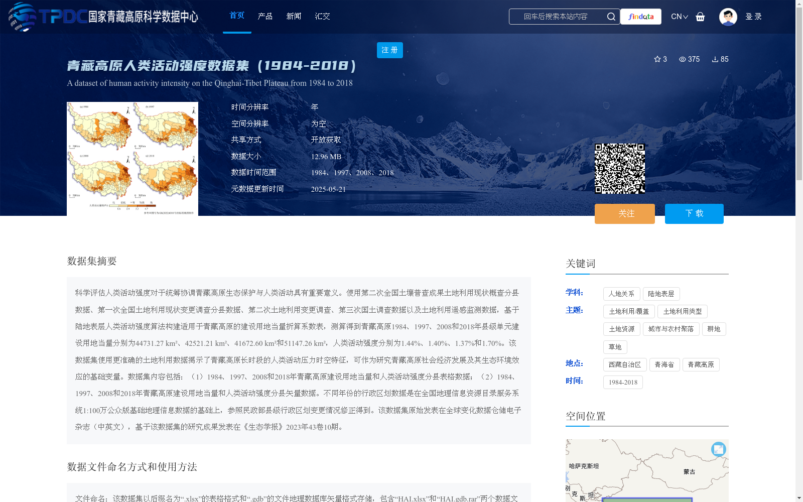
科学评估人类活动强度对于统筹协调青藏高原生态保护与人类活动具有重要意义。使用第二次全国土壤普查成果土地利用现状概查分县数据、第一次全国土地利用现状变更调查分县数据、第二次土地利用变更调查、第三次国土调查数据以及土地利用遥感监测数据,基于陆地表层人类活动强度算法构建适用于青藏高原的建设用地当量折算系数表,测算得到青藏高原1984、1997、2008和2018年县级单元建设用地当量分别为44731.27 km²、42521.21 km²、41672.60 km²和51147.26 km²,人类活动强度分别为1.44%、1.40%、1.37%和1.70%。该数据集使用更准确的土地利用数据揭示了青藏高原长时段的人类活动压力时空特征,可作为研究青藏高原社会经济发展及其生态环境效应的基础变量。数据集内容包括:(1)1984、1997、2008和2018年青藏高原建设用地当量和人类活动强度分县表格数据;(2)1984、1997、2008和2018年青藏高原建设用地当量和人类活动强度分县矢量数据。不同年份的行政区划数据是在全国地理信息资源目录服务系统1:100万公众版基础地理信息数据的基础上,参照民政部县级行政区划变更情况修正得到。该数据集原始发表在全球变化数据仓储电子杂志(中英文),基于该数据集的研究成果发表在《生态学报》2023年43卷10期。
Scientifically evaluating the intensity of human activities is of great significance for coordinating ecological conservation and socio-economic development on the Qinghai-Tibet Plateau. To this end, this study utilized county-level data from the general survey of current land use status in the Second National Soil Survey, county-level data from the First National Land Use Status Change Survey, the Second Land Use Change Survey, the Third National Land Survey, and land use remote sensing monitoring data, and constructed a conversion coefficient table for construction land equivalents tailored to the Qinghai-Tibet Plateau based on the algorithm for quantifying human activity intensity on land surfaces. The construction land equivalents of county-level units on the Qinghai-Tibet Plateau in 1984, 1997, 2008 and 2018 were calculated as 44731.27 km², 42521.21 km², 41672.60 km² and 51147.26 km² respectively, with the corresponding human activity intensities being 1.44%, 1.40%, 1.37% and 1.70%. This dataset reveals the spatiotemporal characteristics of long-term human activity pressure on the Qinghai-Tibet Plateau using more accurate land use data, and can serve as a fundamental variable for studies on the socio-economic development of the Qinghai-Tibet Plateau and its eco-environmental impacts. The dataset contains two parts: (1) County-level tabular data of construction land equivalents and human activity intensities on the Qinghai-Tibet Plateau for the years 1984, 1997, 2008 and 2018; (2) County-level vector data of construction land equivalents and human activity intensities on the Qinghai-Tibet Plateau for the years 1984, 1997, 2008 and 2018. The administrative division data for each year were revised based on the 1:1,000,000 public version basic geographic information data from the National Geographic Information Resource Directory Service System, with reference to the county-level administrative division adjustment records from the Ministry of Civil Affairs. This dataset was originally published in the Electronic Journal of Global Change Data Repository (both Chinese and English versions), and research findings based on this dataset were published in *Acta Ecologica Sinica*, Volume 43, Issue 10, 2023.
提供机构:
杨华,徐勇
创建时间:
2025-05-20
搜集汇总
数据集介绍
背景与挑战
背景概述
该数据集提供了1984、1997、2008和2018年青藏高原县级单元的建设用地当量和人类活动强度数据,基于陆地表层人类活动强度算法构建,揭示了青藏高原长时段的人类活动压力时空特征。数据集包括表格数据和矢量数据两种格式,适用于研究青藏高原社会经济发展及其生态环境效应。
以上内容由遇见数据集搜集并总结生成


