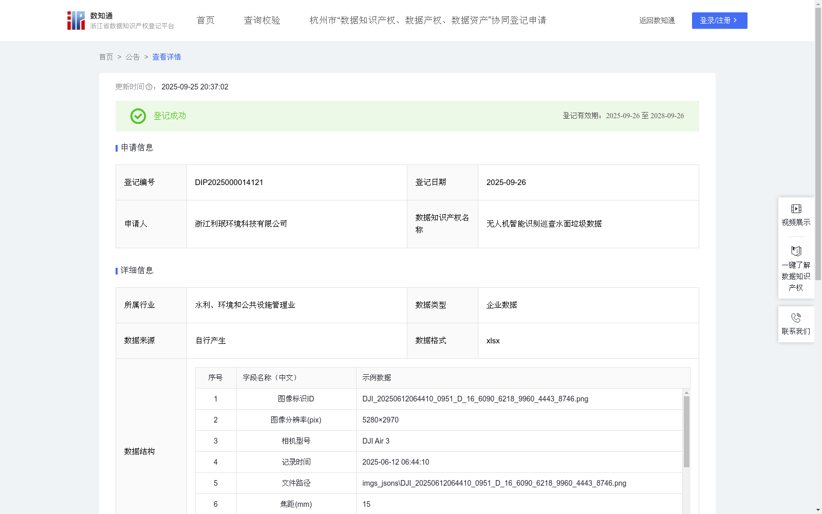
无人机智能识别巡查水面垃圾数据
收藏浙江省数据知识产权登记平台2025-09-25 更新2025-09-26 收录
下载链接:
https://www.zjip.org.cn/home/announce/trends/186119
下载链接
链接失效反馈官方服务:
资源简介:
针对城市道路、河道、城郊公路等,无人机凭借 70 至 100 米的中低空优势,结合高分辨率传感器与 AI 算法,能快速识别路面散落的塑料袋、纸箱、易拉罐等生活垃圾,以及堆积的建筑垃圾、废弃轮胎,道路破损情况等。算法通过分析垃圾与路面的颜色对比(如深色柏油路上的白色塑料袋)、形状特征(如不规则堆积物),精准锁定目标并标记坐标。可高效覆盖长距离路段,弥补人工巡检效率低、存在视野盲区的短板。无人机巡检广泛应用于:
1、城市道路日常巡检:发现道路垃圾,立即标记坐标并同步至环卫调度平台,引导清洁车优先清理,避免垃圾散落影响通行。
2、河道垃圾动态监测:无人机按设定航线低空掠过河道水面,精准识别河道生活垃圾和建筑垃圾等 。实时回传位置信息至河道管理处,协助安排打捞船定点作业,防止垃圾堵塞水闸或腐烂污染水质。
3、道路公路养护巡查:对道路公路进行无人机巡检,除识别路边倾倒的装修废料、生活垃圾外,还能捕捉路面裂缝、坑洼等破损情况。将垃圾分布与道路病害数据整合后,生成综合报告,为养护部门提供 “边清理垃圾边修复路面” 的联动作业依据。1、数据来源: 数据来源于本企业无人机智能巡查系统。2、高分辨率图像通过无人机采集,记录丰富元信息,包括图像标识ID、图像分辨率(pix)、相机型号、记录时间、文件路径、焦距(mm)、经纬度、海拔(m)、边界框组、置信度阈值、置信度、一级标签和二级标签,经人工清洗剔除噪声,确保数据可靠性。数据采用两级标签:初始细化目标类型标为二级标签(水面垃圾),记录边界框及属性,后映射为一级标签(水面漂浮物)。3、算法基于YOLOv8m,集成SAHI通过图像分片优化小目标检测,结合迁移学习加载预训练权重。预训练权重使用在COCO数据集上预训练的模型参数yolov8m.pt,适用于通用目标检测任务。微调时,保留骨干网络低层次特征提取层权重,冻结部分层以防过拟合,调整检测头参数,设置学习率0.01、批量大小8。4、在推理阶段,设定置信度阈值为0.5,目标置信度由模型输出,反映目标检测的可信水平。仅保留高于此阈值的检测结果作为目标,即置信度输出大于等于0.5的检测框视为正样本(水面垃圾),小于0.5的检测框视为背景负样本。
Unmanned Aerial Vehicles (UAVs), leveraging their low-to-medium altitude advantage of 70 to 100 meters combined with high-resolution sensors and AI algorithms, can rapidly identify domestic waste scattered on road surfaces such as plastic bags, cardboard boxes, aluminum cans, accumulated construction waste, waste tires, as well as road damage, for scenarios including urban roads, riverways, and suburban highways. The algorithm accurately locates targets and marks their coordinates by analyzing color contrast between waste and road surfaces (e.g., white plastic bags on dark asphalt) and shape features (e.g., irregularly piled objects). It can efficiently cover long-distance road sections, making up for the shortcomings of low efficiency and visual blind spots in manual inspection.
UAV inspection is widely applied in:
1. Daily urban road inspection: Once road waste is detected, its coordinates are immediately marked and synchronized to the sanitation scheduling platform, guiding cleaning vehicles to prioritize cleanup and prevent scattered waste from affecting traffic flow.
2. Dynamic river waste monitoring: UAVs fly low over river surfaces along preset routes, accurately identifying domestic and construction waste in waterways. They transmit real-time location information to the river management department, assisting in arranging fixed-point operations of salvage vessels to prevent waste from blocking sluices or rotting and polluting water quality.
3. Road and highway maintenance inspection: UAV-based inspections of roads and highways not only identify construction and domestic waste dumped along roadsides but also detect road damages such as cracks and potholes. By integrating waste distribution and road disease data, a comprehensive report is generated, providing a basis for collaborative operations of "cleaning waste while repairing road surfaces" for maintenance departments.
1. Data Source: The dataset is collected from the company's UAV intelligent inspection system.
2. High-resolution images are collected by UAVs, with rich metadata recorded, including image ID, image resolution (pix), camera model, recording time, file path, focal length (mm), longitude and latitude, altitude (m), bounding box groups, confidence threshold, confidence score, primary labels and secondary labels. Noise is eliminated through manual cleaning to ensure data reliability. A two-level labeling system is adopted: the initially refined target type is marked as a secondary label (water surface waste), with bounding boxes and corresponding attributes recorded, and then mapped to a primary label (water surface floating objects).
3. The algorithm is based on YOLOv8m, integrated with SAHI to optimize small object detection via image slicing, and loads pre-trained weights through transfer learning. The pre-trained weights use the yolov8m.pt model parameters pre-trained on the COCO dataset, which is suitable for general object detection tasks. During fine-tuning, the weights of the low-level feature extraction layers of the backbone network are retained, some layers are frozen to prevent overfitting, the detection head parameters are adjusted, with a learning rate of 0.01 and a batch size of 8.
4. In the inference phase, the confidence threshold is set to 0.5. The target confidence output by the model reflects the reliability level of object detection. Only detection results above this threshold are retained as valid targets: detection boxes with a confidence score ≥0.5 are regarded as positive samples (water surface waste), while those with a confidence score <0.5 are regarded as background negative samples.
提供机构:
浙江利珉环境科技有限公司
创建时间:
2025-08-07
搜集汇总
数据集介绍
背景与挑战
背景概述
该数据集包含510条水面垃圾识别数据,每日更新,采用xlsx格式记录无人机采集的高分辨率图像元信息,如时间、位置和置信度。它基于YOLOv8m算法优化小目标检测,适用于城市道路和河道垃圾巡查,实现高效AI识别与坐标标记。
以上内容由遇见数据集搜集并总结生成


