青藏高原沉积物碎屑锆石U-Pb年龄数据
收藏国家青藏高原科学数据中心2022-05-27 更新2024-03-01 收录
下载链接:
https://data.tpdc.ac.cn/zh-hans/data/36174969-22b5-4c9d-ac5c-1cb479da2b05
下载链接
链接失效反馈官方服务:
资源简介:
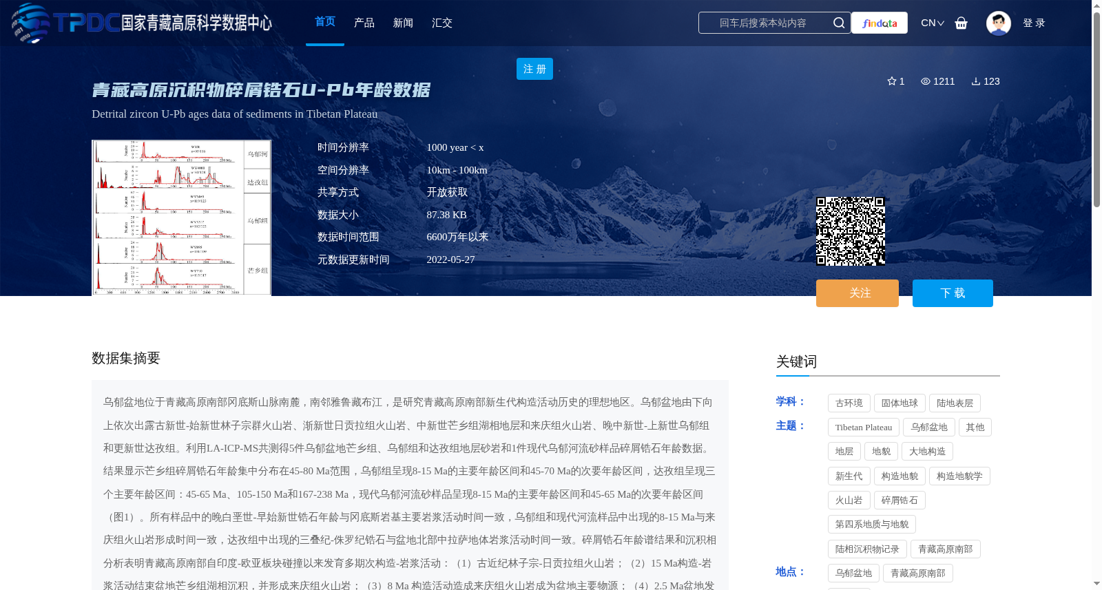
乌郁盆地位于青藏高原南部冈底斯山脉南麓,南邻雅鲁藏布江,是研究青藏高原南部新生代构造活动历史的理想地区。乌郁盆地由下向上依次出露古新世-始新世林子宗群火山岩、渐新世日贡拉组火山岩、中新世芒乡组湖相地层和来庆组火山岩、晚中新世-上新世乌郁组和更新世达孜组。利用LA-ICP-MS共测得5件乌郁盆地芒乡组、乌郁组和达孜组地层砂岩和1件现代乌郁河流砂样品碎屑锆石年龄数据。结果显示芒乡组碎屑锆石年龄集中分布在45-80 Ma范围,乌郁组呈现8-15 Ma的主要年龄区间和45-70 Ma的次要年龄区间,达孜组呈现三个主要年龄区间:45-65 Ma、105-150 Ma和167-238 Ma,现代乌郁河流砂样品呈现8-15 Ma的主要年龄区间和45-65 Ma的次要年龄区间(图1)。所有样品中的晚白垩世-早始新世锆石年龄与冈底斯岩基主要岩浆活动时间一致,乌郁组和现代河流样品中出现的8-15 Ma与来庆组火山岩形成时间一致,达孜组中出现的三叠纪-侏罗纪锆石与盆地北部中拉萨地体岩浆活动时间一致。碎屑锆石年龄谱结果和沉积相分析表明青藏高原南部自印度-欧亚板块碰撞以来发育多期次构造-岩浆活动:(1)古近纪林子宗-日贡拉组火山岩;(2)15 Ma构造-岩浆活动结束盆地芒乡组湖相沉积,并形成来庆组火山岩;(3)8 Ma 构造活动造成来庆组火山岩成为盆地主要物源;(4)2.5 Ma盆地发育辫状河,接受北部中拉萨地体物源。第四纪以来,青藏高原南部地貌格局逐渐形成。
The Wuyu Basin, located on the southern foothills of the Gangdese Mountains in southern Tibetan Plateau and bordering the Yarlung Zangbo River to the south, is an ideal locality for investigating the Cenozoic tectonic activity history of southern Tibet. From bottom to top, the basin successively exposes the Paleocene-Eocene Linzizong Group volcanic rocks, Oligocene Rigongla Formation volcanic rocks, Miocene Mangxiang Formation lacustrine strata and Laiqing Formation volcanic rocks, Late Miocene-Pliocene Wuyu Formation, and Pleistocene Dazi Formation. Using LA-ICP-MS, we obtained detrital zircon U-Pb age data for 5 sandstone samples collected from the Mangxiang, Wuyu and Dazi Formations in the Wuyu Basin, as well as 1 modern fluvial sand sample from the Wuyu River. The results demonstrate that detrital zircons from the Mangxiang Formation are concentrated within the 45–80 Ma age range; the Wuyu Formation exhibits a dominant age interval of 8–15 Ma and a subordinate interval of 45–70 Ma; the Dazi Formation has three major age intervals: 45–65 Ma, 105–150 Ma and 167–238 Ma; and the modern Wuyu River sand sample displays a dominant age interval of 8–15 Ma and a subordinate interval of 45–65 Ma (Fig. 1). Late Cretaceous-Early Eocene zircon ages from all samples are consistent with the main magmatic activity episodes of the Gangdese batholith. The 8–15 Ma ages identified in the Wuyu Formation and modern fluvial samples match the formation timing of the Laiqing Formation volcanic rocks, while the Triassic-Jurassic zircons in the Dazi Formation correspond to magmatic activity in the central Lhasa terrane north of the basin. Detrital zircon age spectra and sedimentary facies analysis reveal that multiple phases of tectono-magmatic activity have developed in southern Tibet since the India-Eurasia plate collision: (1) Paleogene Linzizong-Rigongla Formation volcanic activity; (2) The 15 Ma tectono-magmatic activity terminated the lacustrine deposition of the Mangxiang Formation and formed the Laiqing Formation volcanic rocks; (3) The 8 Ma tectonic activity made the Laiqing Formation volcanic rocks the primary provenance of the basin; (4) At ~2.5 Ma, braided rivers developed in the basin, which received provenance from the northern central Lhasa terrane. The geomorphic framework of southern Tibet has gradually taken shape since the Quaternary.
提供机构:
孟庆泉
创建时间:
2022-05-11
搜集汇总
数据集介绍
背景与挑战
背景概述
该数据集包含青藏高原南部乌郁盆地新生代地层及现代河流砂的碎屑锆石U-Pb年龄数据,通过LA-ICP-MS技术测定,揭示了45-80 Ma、8-15 Ma等多个年龄区间,用于研究印度-欧亚板块碰撞以来青藏高原南部的多期次构造-岩浆活动历史。数据时间范围为6600万年以来,空间分辨率为10km-100km,以开放获取方式共享,数据量为87.38 KB。
以上内容由遇见数据集搜集并总结生成


