塔吉克斯坦未来不同社会发展情景土地利用格局预测数据集(2040、2060)
收藏国家青藏高原科学数据中心2025-08-29 更新2025-08-30 收录
下载链接:
https://data.tpdc.ac.cn/zh-hans/data/a3ef3957-9012-4451-9793-a04ca175b5c8
下载链接
链接失效反馈官方服务:
资源简介:
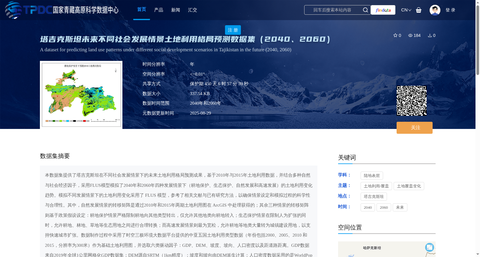
本数据集提供了塔吉克斯坦在不同社会发展情景下的未来土地利用格局预测成果,基于2010年与2015年土地利用数据,并结合多种自然与社会经济因子,采用FLUS模型模拟了2040年和2060年四种发展情景下(耕地保护、生态保护、自然发展和高速发展)的土地利用变化趋势。模拟不同发展情景下的土地利用变化采用了 FLUS 模型,参考了相关文献与已有研究方法,以确保情景设定和模拟过程的科学性与合理性。其中,自然发展情景的转移矩阵是通过2010年和2015年两期土地利用图在 ArcGIS 中处理获得的;其余三种情景的转移矩阵则基于政策假设设定:耕地保护情景严格限制耕地向其他类型转出,仅允许其他地类向耕地转入;生态保护情景在限制人为扩张的同时,允许耕地、林地、草地等生态用地之间进行合理转换;而高速发展情景则最为宽松,允许耕地等地类大量转为城镇建设用地,以支持快速城市扩张。数据制作过程中采用了时空三极环境大数据平台提供的中亚五国土地利用类型数据(年份包括2000、2005、2010 和 2015,分辨率为300米)作为基础土地利用图,并选取六类驱动因子:GDP、DEM、坡度、坡向、人口密度以及距道路距离。GDP数据来自2019年全球1公里网格化GDP数据集;DEM源自SRTM(1km精度);坡度和坡向由DEM派生计算;人口密度数据采用的是WorldPop全球1公里人口分布数据;距道路距离则基于OpenStreetMap道路数据计算欧氏距离。所有数据均统一投影,空间分辨率为1公里,并通过掩膜提取、像元对齐和归一化等标准化流程进行预处理。土地利用模拟采用 FLUS 模型,综合马尔可夫链模型(Markov)、人工神经网络(ANN)和元胞自动机(CA)方法。马尔可夫模型基于历史土地利用图预测未来各土地类型的数量变化;ANN 模型利用当前土地利用图与驱动因子训练,生成各类土地的空间适宜性概率图;CA 模型则结合 ANN 的空间概率、Markov 的数量约束以及邻域扩散规则,完成对土地利用空间分布的动态模拟。三者协同实现了土地利用变化在数量与空间上的耦合预测。模型模拟精度经 Kappa 系数评估均高于 0.94,表明预测结果具有较高可信度。本数据集包括不同情景下的土地利用分类图,地类包括:耕地、林地、草地、水体、未利用地和建设用地。可广泛应用于国土空间规划、生态保护区划、城市扩展管理和耕地保护政策评估等领域,为应对人口增长、经济发展与气候变化等带来的土地格局演变提供可靠的模拟依据与决策支撑。
This dataset provides future land use pattern prediction results for Tajikistan under different socioeconomic development scenarios. Based on land use data from 2010 and 2015, combined with multiple natural and socioeconomic factors, the FLUS Model was adopted to simulate land use change trends in 2040 and 2060 across four development scenarios: Cultivated Land Protection, Ecological Protection, Natural Development, and Rapid Development.
The simulation of land use changes across these scenarios was performed using the FLUS Model, drawing on peer-reviewed literature and proven research methodologies to guarantee the scientific rigor and reasonableness of both scenario design and the simulation workflow. Specifically, the transition matrix for the Natural Development scenario was obtained by processing two phases of land use maps from 2010 and 2015 in ArcGIS; the transition matrices for the other three scenarios were set based on policy assumptions: the Cultivated Land Protection scenario strictly prohibits the conversion of cultivated land to other land types, only allowing the transfer of non-cultivated land into cultivated land; the Ecological Protection scenario restricts anthropogenic expansion while permitting reasonable conversions among ecological land types including cultivated land, forest land, and grassland; the Rapid Development scenario is the most permissive, allowing large-scale conversion of cultivated land and other types into urban construction land to support rapid urban expansion.
In the data production process, land use type data of the five Central Asian countries (covering years 2000, 2005, 2010 and 2015, with a spatial resolution of 300 m) provided by the Spatiotemporal Three-Polar Environmental Big Data Platform were used as the base land use maps, and six categories of driving factors were selected: GDP, DEM, slope, aspect, population density, and distance to roads. GDP data were sourced from the 2019 global 1-km gridded GDP dataset; DEM data were obtained from SRTM (1 km resolution); slope and aspect were derived and calculated from the DEM; population density data used the WorldPop global 1-km population distribution dataset; and distance to roads was calculated as the Euclidean distance based on OpenStreetMap road data. All data were uniformly projected to a spatial resolution of 1 km, and preprocessed via standardization workflows including mask extraction, pixel alignment, and normalization.
The land use simulation was conducted using the FLUS Model, which integrates three methodologies: the Markov Chain Model, Artificial Neural Network (ANN), and Cellular Automaton (CA). The Markov Chain Model predicts the quantitative changes of each land use type in the future based on historical land use maps; the ANN model is trained using current land use maps and driving factors to generate spatial suitability probability maps for each land type; the CA model combines the spatial probabilities from the ANN, the quantitative constraints from the Markov Model, and neighborhood diffusion rules to complete the dynamic simulation of land use spatial distribution. The collaboration of these three models achieves coupled prediction of land use changes in both quantitative and spatial dimensions. The simulation accuracy was evaluated using the Kappa coefficient, with all values exceeding 0.94, indicating that the prediction results have high reliability.
This dataset includes land use classification maps under different scenarios, with land types covering cultivated land, forest land, grassland, water bodies, unused land, and construction land. It can be widely applied in fields such as territorial spatial planning, ecological protection zoning, urban expansion management, and cultivated land protection policy assessment, providing reliable simulation evidence and decision support for addressing land pattern changes caused by population growth, economic development, and climate change.
提供机构:
陈望雨,郭浩,伍永秋,贾佳
创建时间:
2025-07-10
搜集汇总
数据集介绍
背景与挑战
背景概述
该数据集预测了塔吉克斯坦在2040年和2060年四种社会发展情景下的土地利用格局,基于FLUS模型和高精度驱动因子,为国土规划和生态保护提供科学依据。
以上内容由遇见数据集搜集并总结生成


