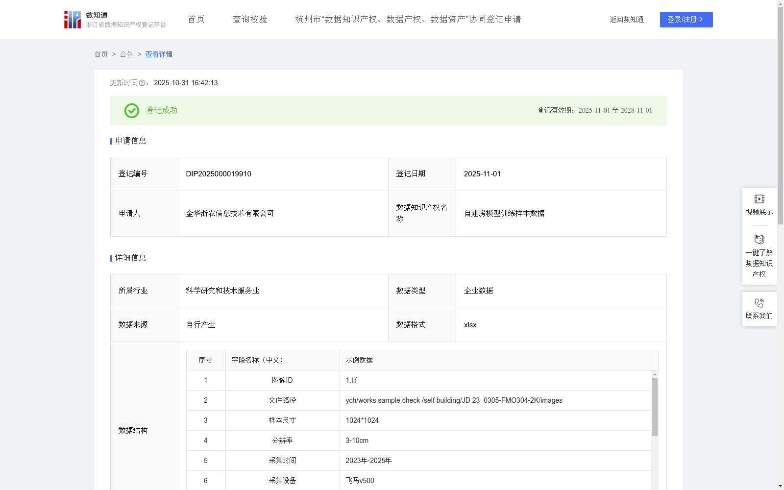
自建房模型训练样本数据
收藏浙江省数据知识产权登记平台2025-10-31 更新2025-11-01 收录
下载链接:
https://www.zjip.org.cn/home/announce/trends/7254990
下载链接
链接失效反馈官方服务:
资源简介:
1、精准确权无人机通过倾斜摄影与三维建模技术,生成厘米级精度的房屋空间数据,建立“一户一档”可视化档案,作为产权登记的空间权属电子证据链,对历史建成但无图纸的农村自建房,通过三维点云数据还原建筑结构边界,解决邻里权属纠纷。
2、违规建筑智能监管:融合AI图像识别算法,自动比对申报建筑与航拍数据的结构差异(如层高、面积、屋顶形态),标记疑似违建区域并生成风险预警知识产权报告。构建区域违建特征数据库,形成具有商业价值的建筑合规性评估模型。1、数据采集:利用飞马v500无人机,利用自动拼图得到1cm-3cm分辨率的无人机正射影像数据,并设置CGCS2000 / 3°投影坐标系,影像分辨率以及影像坐标系等参数同步加入至影像数据中。
2、数据预处理以及数据标注:首先,选择适用于样本的影像,明确裁切区域并绘制范围矢量;利用矢量数据裁切影像,采用在线标记点位并添加作物属性的方式,以点位为中心点进行裁剪,生成指定尺寸(如256*256)的影像切片。
3、数据集设置以及模型选择:按照7:2:1的比例设置训练集、验证集和测试集。使用自行搭建的TransCNN-Vision模型进行训练。
5、训练设置:模型选择与初始化以vision_transformer的large模型为权重文件,初始化常规模型参数后,读取数据集文件夹个数确定模型分类数,最优学习率为0.001,同时冻结出head和pre_logits外的所有权重参数,batchsize,根据当前设备现存余量自动调整,默认值为16,根据样本分辨率动态调整patch_size用于提高不同分辨率下的特征捕获能力。最后利用自适应高精度模型保存策略,自动保存训练精度mDice(Mean Dice Coefficient)指标最高模型的模型作为最佳模型。mDice计算公式如下: mDice=2*|X∩Y|/(|X|+|Y|)。
训练mDice指数基于对测试集样本数据预测并计算获得,其中|X∩Y|为预测结果与真实标注的交集,| X |和| Y |分别为预测结果与真实标签的各自的数量之和。
5、模型精度评估:通过在真实影像中进行模型提取并人工校正,实现对模型在真实场景中的提取效果。利用提取错误率和提取遗漏率指标来评估被识别物模型的提取能力,提取错误率用于评估模型提取结果中不是合理的比例,提取遗漏率用于评估模型提取结果依然没有提取出被识别物的比例,提取遗漏率越接近4.2%,提取错误率越接近6.2%,表明当前提取结果准确率越高,能够降低的成本越高。提取错误率计算公式如下:(|X|-|X∩Y|)/|X|。
提取遗漏率计算公式如下:(|Y|-|X∩Y|)/|Y|。其中,|X∩Y|为正确识别为被识别物的数量,| X |和| Y |分别为预测和真实的被识别数量。考虑到真实场景的复杂性,提取错误率和提取遗漏率保持在10%以内即可视为结果具有较高的准确性。
1. Accurate Right Confirmation: Through oblique photography and 3D modeling technologies, the UAV generates centimeter-level accurate spatial data of houses, and establishes a "one household, one file" visual archive, which serves as the spatial ownership electronic evidence chain for property right registration. For historical rural self-built houses that were completed but have no drawings, 3D point cloud data is used to restore the structural boundaries of buildings, so as to resolve neighborhood ownership disputes.
2. Intelligent Supervision of Illegal Buildings: Integrate AI image recognition algorithms to automatically compare the structural differences between declared buildings and aerial photography data (such as floor height, floor area, roof shape), mark suspected illegal construction areas and generate risk warning intellectual property reports. Build a regional illegal construction feature database, and form a commercially valuable building compliance assessment model.
1. Data Collection: Use the Feima V500 UAV to obtain 1cm-3cm resolution UAV orthophoto data through automatic mosaicking, set the CGCS2000 / 3° projected coordinate system, and synchronize parameters such as image resolution and image coordinate system into the image data.
2. Data Preprocessing and Annotation: First, select applicable sample images, define the cropping area and draw the scope vector; crop the images using vector data, mark points online and add crop attributes, crop with the point as the center, and generate image slices of specified dimensions (e.g., 256*256).
3. Dataset Setup and Model Selection: Set the training set, validation set, and test set at a ratio of 7:2:1. Use the self-developed TransCNN-Vision model for training.
5. Training Settings: Initialize the model with the weights of the vision_transformer large model. After initializing the conventional model parameters, determine the number of model classification categories by reading the number of dataset folders. The optimal learning rate is 0.001. Freeze all weight parameters except head and pre_logits. The batch size is automatically adjusted based on the remaining video memory of the current device, with a default value of 16. Dynamically adjust the patch_size according to the sample resolution to improve the feature capture capability under different resolutions. Finally, use the adaptive high-precision model saving strategy to automatically save the model with the highest training accuracy mDice (Mean Dice Coefficient) as the best model.
The formula for mDice is as follows: mDice=2*|X∩Y|/(|X|+|Y|).
The training mDice index is obtained by predicting and calculating the test set sample data, where |X∩Y| is the intersection of the prediction results and the ground truth annotations, and |X| and |Y| are the total counts of the prediction results and ground truth labels respectively.
5. Model Accuracy Evaluation: Extract via the model on real images and manually correct, so as to evaluate the model's extraction performance in real scenarios. Use the extraction error rate and extraction omission rate metrics to evaluate the extraction capability of the identified object model. The extraction error rate is used to evaluate the proportion of unreasonable results in the model's extraction outputs. The extraction omission rate is used to evaluate the proportion of identified objects that were not extracted by the model. The closer the extraction omission rate is to 4.2% and the extraction error rate is to 6.2%, the higher the accuracy of the current extraction results and the greater the reducible cost.
The formula for the extraction error rate is as follows: (|X| - |X∩Y|)/|X|.
The formula for the extraction omission rate is as follows: (|Y| - |X∩Y|)/|Y|, where |X∩Y| is the number of correctly identified target objects, and |X| and |Y| are the predicted and actual counts of the target objects respectively. Considering the complexity of real scenarios, if the extraction error rate and extraction omission rate are both within 10%, the results can be considered to have high accuracy.
提供机构:
金华浙农信息技术有限公司
创建时间:
2025-09-09
搜集汇总
数据集介绍
背景与挑战
背景概述
该数据集是用于自建房模型训练的样本数据,包含13930条记录,数据格式为xlsx,涵盖图像ID、分辨率、采集时间等关键字段。数据集应用于精准确权和违规建筑监管场景,采用TransCNN-Vision模型进行训练,提取错误率和遗漏率分别为5.6%和8.1%,具有较高的准确性。
以上内容由遇见数据集搜集并总结生成


