2001年青藏高原Landsat TM/ETM+冰川格网数据产品
收藏地球大数据科学工程2024-03-04 收录
下载链接:
https://data.casearth.cn/sdo/detail/5c19a5690600cf2a3c557ba7
下载链接
链接失效反馈官方服务:
资源简介:
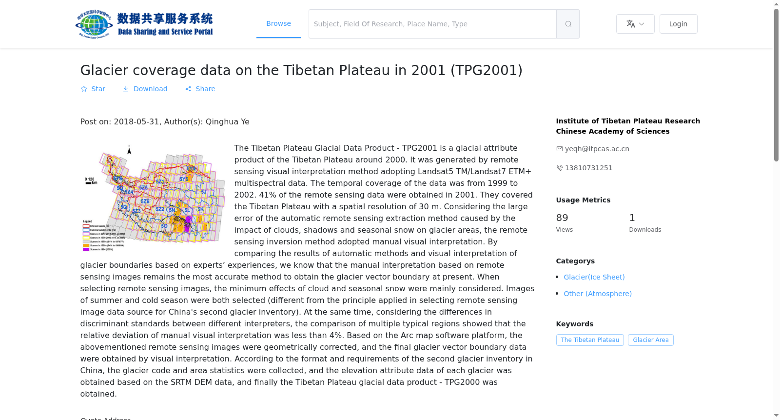
“青藏高原冰川格网数据产品-TPG2001”为2000年左右的青藏高原冰川属性产品,采用Landsat5 TM/Landsat7 ETM+多光谱数据基于遥感目视解译方法制作,数据覆盖时间从1999年到2002年,其中41%的遥感数据源来自于2001年。覆盖范围为青藏高原,遥感数据源的空间分辨率为30m。遥感反演方法采用人工目视解译,主要考虑了基于自动化遥感提取方法获得的冰川面积易受云、阴影和季节性积雪的影响,进而利用遥感自动化提取方法会导致较大的误差。通过对比自动化方法和结合专家经验目视解译冰川边界的结果,可知目前基于遥感影像的人工目视解译仍是获得冰川矢量边界的最准确的方法。选取遥感影像时主要考虑最小云影响和最小季节性积雪影响,选取的影像时间即包括夏季也包括冷季(与中国第二次冰川编目选择遥感影像数据源的原则略有不同)。同时考虑到人为目视解译时不同解译人员之间的判别标准差异,通过多个典型区域对比表明人工目视解译的相对偏差小于4%。基于Arc map软件平台对上述遥感影像进行几何校正后通过目视解译获得最终的冰川矢量边界数据,按照中国第二次冰川编目的格式和要求,对上述矢量数据进行冰川编号和面积统计,并基于SRTM DEM数据获得各冰川的高程属性数据等,最终得到TPG2000青藏高原冰川格网数据产品。
The Qinghai-Tibet Plateau Glacier Grid Data Product - TPG2001 is a glacier attribute product of the Qinghai-Tibet Plateau around 2000. It was produced using Landsat5 TM/Landsat7 ETM+ multispectral data through remote sensing visual interpretation methods. The data coverage period ranges from 1999 to 2002, with 41% of the remote sensing data sources coming from 2001. The coverage scope is the Qinghai-Tibet Plateau, and the spatial resolution of the remote sensing data sources is 30 m. The remote sensing inversion method adopts manual visual interpretation, mainly considering that the glacier area obtained by automated remote sensing extraction methods is easily affected by clouds, shadows and seasonal snow cover, which will lead to large errors when using automated remote sensing extraction methods. By comparing the results of automated methods and glacier boundary visual interpretation combined with expert experience, it can be seen that manual visual interpretation based on remote sensing images is still the most accurate method for obtaining glacier vector boundaries at present. When selecting remote sensing images, the main considerations are minimal cloud impact and minimal seasonal snow cover impact. The selected image times include both summer and cold seasons (slightly different from the principles of selecting remote sensing image data sources for the Second Chinese Glacier Inventory). At the same time, considering the differences in discrimination standards among different interpreters during manual visual interpretation, comparisons across multiple typical regions show that the relative deviation of manual visual interpretation is less than 4%. After geometric correction of the above remote sensing images based on the ArcMap software platform, the final glacier vector boundary data was obtained through visual interpretation. According to the format and requirements of the Second Chinese Glacier Inventory, glacier numbering and area statistics were carried out on the above vector data, and elevation attribute data of each glacier was obtained based on SRTM DEM data. Finally, the TPG2000 Qinghai-Tibet Plateau Glacier Grid Data Product was obtained.
提供机构:
中科院青藏高原研究所
搜集汇总
数据集介绍
背景与挑战
背景概述
该数据集是2001年青藏高原冰川覆盖数据产品,基于Landsat TM/ETM+多光谱数据,采用人工视觉解释方法生成,空间分辨率为30米,时间覆盖1999-2002年,主要用于冰川边界和面积统计研究。
以上内容由遇见数据集搜集并总结生成


