青藏高原中部土壤温湿度多尺度观测网数据集(2010-2021)
收藏国家青藏高原科学数据中心2021-12-27 更新2024-03-01 收录
下载链接:
https://data.tpdc.ac.cn/zh-hans/data/b6269aeb-8b44-4d03-b514-2c804c2cfc26
下载链接
链接失效反馈官方服务:
资源简介:
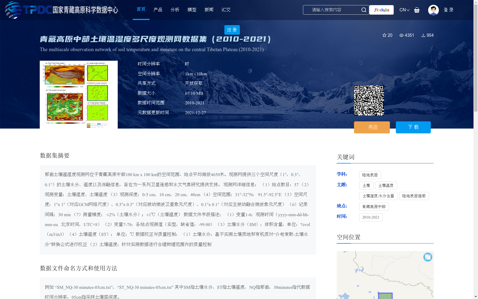
那曲土壤温湿度观测网位于青藏高原中部100 km x 100 km的空间范围,站点平均海拔4650米。观测网提供三个空间尺度(1°、0.3°、0.1°)的土壤水分、温度以及冻融信息,旨在为一系列卫星遥感和水文气象研究提供支持。
观测网详细信息:
(1)站点数目:57
(2)观测变量:土壤湿度、土壤温度
(3)观测深度:0-5 cm、10 cm、20 cm、40cm
(4)空间范围:31°-32°N; 91.5°-92.5°E
(5)空间尺度:1°x 1°(对应GCM网格尺度)、0.3°x 0.3°(对应被动微波卫星象元尺度)、0.1°x 0.1°(对应主被动融合微波象元尺度)
(6)记录间隔:30 min
(7)测量精度: ±2%(土壤水分);±1℃(土壤温度)
数据文件字段描述:
(1)变量1-6:观测时间(yyyy-mm-dd-hh-mm-ss;北京时间,UTC+8)
(2)变量7-78:各站点观测值(实型,缺省值:-99.00)
(3)土壤水分(SM):体积含量,单位:%vol(m3/m3)
(4)土壤温度(ST): 单位:℃
数据校正与质量控制:
(1)土壤水分:基于实测土壤质地和有机质对“介电常数-土壤水分”转换公式进行校正
(2)土壤温度:针对实测数据进行合理物理范围内的质量控制
The Naqu Soil Temperature and Moisture Observation Network is situated in the central Tibetan Plateau, spanning a 100 km × 100 km spatial domain, with an average station elevation of 4650 meters. The network provides soil moisture, soil temperature, and freeze-thaw information at three spatial scales (1°, 0.3°, and 0.1°), aiming to support a series of satellite remote sensing and hydrometeorological research.
Detailed information of the observation network:
(1) Number of stations: 57
(2) Observed variables: Soil moisture, soil temperature
(3) Observation depths: 0–5 cm, 10 cm, 20 cm, 40 cm
(4) Spatial coverage: 31°–32°N; 91.5°–92.5°E
(5) Spatial scales: 1° × 1° (corresponding to the grid scale of General Circulation Models (GCMs)), 0.3° × 0.3° (corresponding to the passive microwave satellite pixel scale), and 0.1° × 0.1° (corresponding to the active-passive combined microwave pixel scale)
(6) Recording interval: 30 minutes
(7) Measurement accuracy: ±2% (soil moisture); ±1℃ (soil temperature)
Data file field descriptions:
(1) Variables 1–6: Observation time (yyyy-mm-dd-hh-mm-ss; Beijing Time, UTC+8)
(2) Variables 7–78: Observed values from each station (real number type, default value: -99.00)
(3) Soil Moisture (SM): Volumetric content, unit: %vol (m³/m³)
(4) Soil Temperature (ST): Unit: ℃
Data correction and quality control:
(1) Soil moisture: Corrections are applied to the "dielectric constant-soil moisture" conversion formula based on measured soil texture and organic matter content
(2) Soil temperature: Quality control within a physically reasonable range is conducted on the measured data
提供机构:
阳坤,陈莹莹,赵龙,秦军,拉珠,周旭,姜尧志,田佳鑫
创建时间:
2021-12-20
搜集汇总
数据集介绍
背景与挑战
背景概述
该数据集提供了2010-2021年青藏高原中部那曲地区土壤温湿度的多尺度观测数据,覆盖100 km x 100 km范围,平均海拔4650米,包含57个站点,以30分钟间隔记录土壤湿度和温度,深度从0-5 cm到40 cm,空间分辨率涵盖1°、0.3°和0.1°三个尺度,旨在支持卫星遥感和水文气象研究。数据经过校正和质量控制,测量精度高(土壤水分±2%、土壤温度±1℃),并以开放获取方式共享,总大小为67.10 MB。
以上内容由遇见数据集搜集并总结生成


