five

JAFFE 表情识别数据集|人脸识别数据集|情感分析数据集

收藏
超神经2023-09-12 更新2024-05-15 收录
人脸识别
情感分析
下载链接:
https://hyper.ai/cn/datasets/17880
下载链接
链接失效反馈
资源简介:
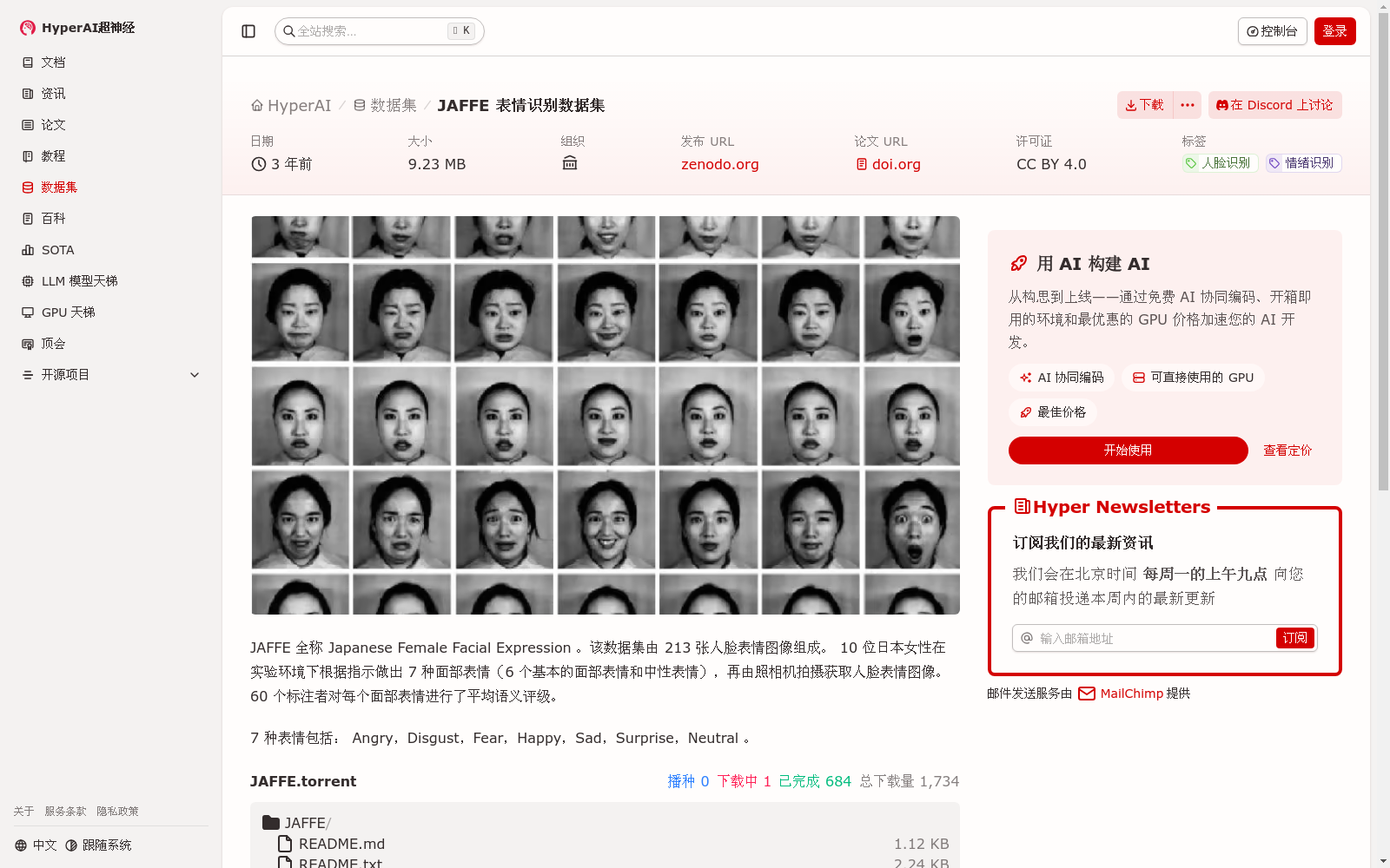
JAFFE 全称 Japanese Female Facial Expression 。该数据集由 213 张人脸表情图像组成。 10 位日本女性在实验环境下根据指示做出 7 种面部表情(6 个基本的面部表情和中性表情),再由照相机拍摄获取人脸表情图像。 60 个标注者对每个面部表情进行了平均语义评级。
创建时间:
2023-04-04
用户留言
有没有相关的论文或文献参考?
这个数据集是基于什么背景创建的?
数据集的作者是谁?
能帮我联系到这个数据集的作者吗?
这个数据集如何下载?
点击留言
数据主题
具身智能
数据集  4098个
机构  8个
大模型
数据集  439个
机构  10个
无人机
数据集  37个
机构  6个
指令微调
数据集  36个
机构  6个
蛋白质结构
数据集  50个
机构  8个
空间智能
数据集  21个
机构  5个
5,000+
优质数据集
54 个
任务类型
进入经典数据集
热门数据集

VoxBox

VoxBox是一个大规模语音语料库,由多样化的开源数据集构建而成,用于训练文本到语音(TTS)系统。

github 收录

中国劳动力动态调查

“中国劳动力动态调查” (China Labor-force Dynamics Survey,简称 CLDS)是“985”三期“中山大学社会科学特色数据库建设”专项内容,CLDS的目的是通过对中国城乡以村/居为追踪范围的家庭、劳动力个体开展每两年一次的动态追踪调查,系统地监测村/居社区的社会结构和家庭、劳动力个体的变化与相互影响,建立劳动力、家庭和社区三个层次上的追踪数据库,从而为进行实证导向的高质量的理论研究和政策研究提供基础数据。

中国学术调查数据资料库 收录

AIS数据集

该研究使用了多个公开的AIS数据集,这些数据集经过过滤、清理和统计分析。数据集涵盖了多种类型的船舶,并提供了关于船舶位置、速度和航向的关键信息。数据集包括来自19,185艘船舶的AIS消息,总计约6.4亿条记录。

github 收录

全国 1∶200 000 数字地质图(公开版)空间数据库

As the only one of its kind, China National Digital Geological Map (Public Version at 1∶200 000 scale) Spatial Database (CNDGM-PVSD) is based on China' s former nationwide measured results of regional geological survey at 1∶200 000 scale, and is also one of the nationwide basic geosciences spatial databases jointly accomplished by multiple organizations of China. Spatially, it embraces 1 163 geological map-sheets (at scale 1: 200 000) in both formats of MapGIS and ArcGIS, covering 72% of China's whole territory with a total data volume of 90 GB. Its main sources is from 1∶200 000 regional geological survey reports, geological maps, and mineral resources maps with an original time span from mid-1950s to early 1990s. Approved by the State's related agencies, it meets all the related technical qualification requirements and standards issued by China Geological Survey in data integrity, logic consistency, location acc racy, attribution fineness, and collation precision, and is hence of excellent and reliable quality. The CNDGM-PVSD is an important component of China' s national spatial database categories, serving as a spatial digital platform for the information construction of the State's national economy, and providing informationbackbones to the national and provincial economic planning, geohazard monitoring, geological survey, mineral resources exploration as well as macro decision-making.

DataCite Commons 收录

URPC系列数据集, S-URPC2019, UDD

URPC系列数据集包括URPC2017至URPC2020DL,主要用于水下目标的检测和分类。S-URPC2019专注于水下环境的特定检测任务。UDD数据集信息未在README中详细描述。

github 收录