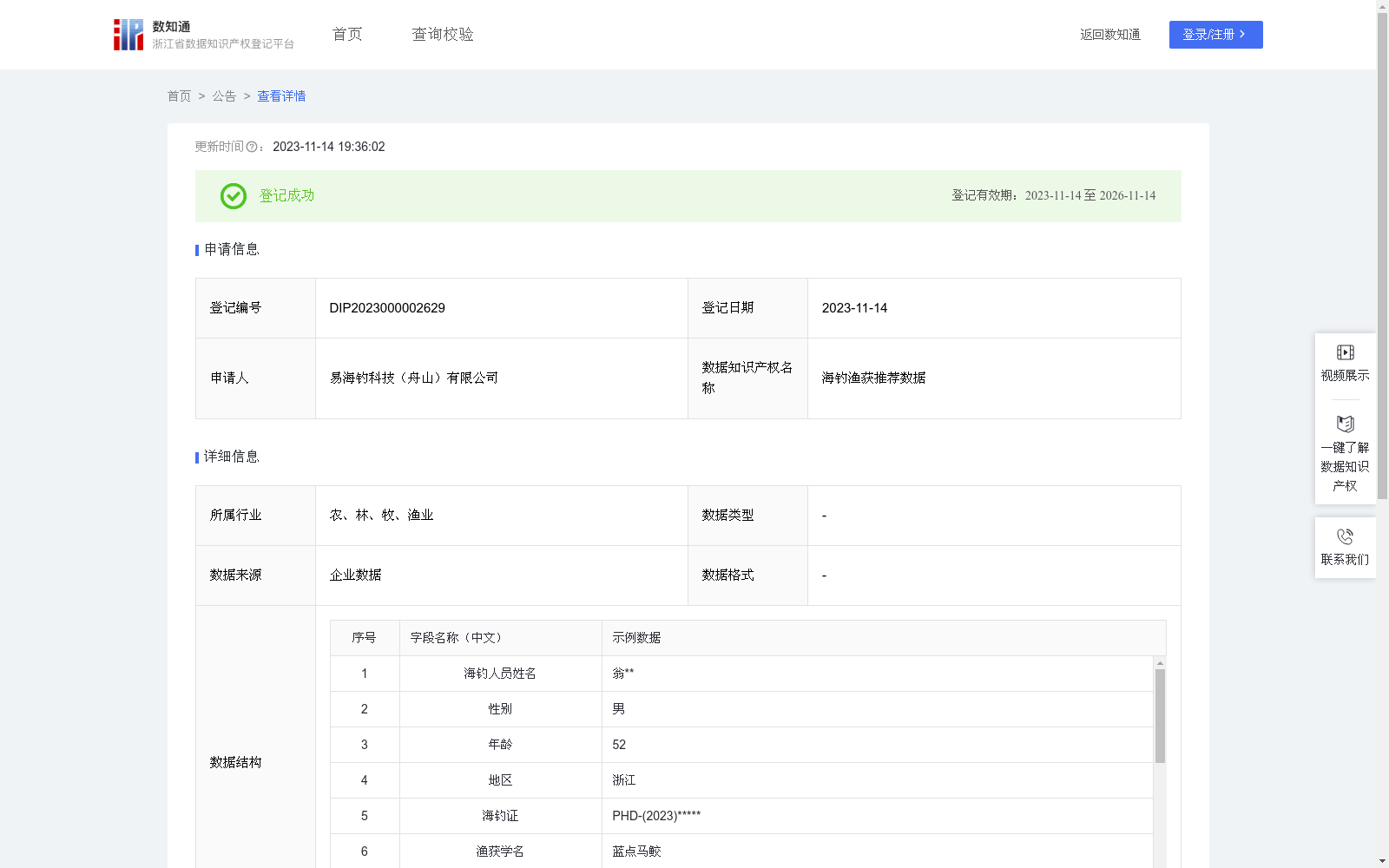
海钓渔获推荐数据
收藏浙江省数据知识产权登记平台2023-11-14 更新2024-05-08 收录
下载链接:
https://www.zjip.org.cn/home/announce/trends/10578
下载链接
链接失效反馈官方服务:
资源简介:
通过海钓人员对每次出海钓鱼的数据的登记,可以对浙江海域内海钓渔业资源的分布情况、不同季节鱼群的回流情况、不同钓点适合渔具的推荐等进行普及与推荐。钓点数据的坐标为geom数据,主要对geom数据进行加工处理,数据存储为WKT格式,一部分描述空间几何对象的类型和坐标系信息(例:LINESTRING (x1 y1, x2 y2, ..., xn yn)),另一部分则是空间几何对象的坐标点的序列,系统通过坐标类型的枚举匹配识别出当前WKT的对象类型,然后根据对象类型对其包含的空间信息进行二次处理,根据点、线、面、多线、多面等情况进行处理后生成经纬度列表数据list,根据射线法判断两个面是否相交,射线法主要思想是从一个点(通常是多边形的重心)发出一条射线,然后计算这条射线穿过多边形的边数。如果穿过的边数为奇数,则这个点在多边形内部;反之则在多边形外部。最后将list划分至对应的钓场,海钓游客在出海钓鱼的过程中,根据其当前经纬度位置来判断所处钓场,并将该钓场适合什么季节钓鱼、鱼获种类等数据进行展示。
By collecting records of each sea fishing trip submitted by recreational sea anglers, this dataset enables the popularization and targeted recommendations regarding the distribution of fishery resources in Zhejiang coastal waters, the seasonal migration patterns of fish stocks, and suitable fishing gears for different fishing spots.
The coordinate data of fishing spots are stored as geom data, which is mainly processed and saved in the Well-Known Text (WKT) format. A WKT string consists of two parts: one describes the type and coordinate system information of the spatial geometric object (e.g., LINESTRING (x1 y1, x2 y2, ..., xn yn)), and the other is the sequence of coordinate points of the spatial geometric object. The system identifies the object type of the current WKT string via enumeration matching of coordinate types, then performs secondary processing on the contained spatial information based on the object type. After processing cases such as points, lines, polygons, multi-lines and multi-polygons, longitude-latitude list data is generated.
The ray-casting algorithm is used to determine whether two polygons intersect. The core idea of this algorithm is to emit a ray from a point (usually the centroid of the polygon), then count the number of edges of the polygon that the ray crosses. If the number of crossed edges is odd, the point is inside the polygon; otherwise, it is outside the polygon.
Finally, the generated longitude-latitude list data is categorized into corresponding fishing grounds. During their sea fishing trips, recreational sea anglers can determine the fishing ground they are in based on their current longitude-latitude position, and the system will display data such as the suitable fishing seasons and target fish species for that fishing ground.
提供机构:
易海钓科技(舟山)有限公司
创建时间:
2023-10-30
搜集汇总
数据集介绍
以上内容由遇见数据集搜集并总结生成


