格陵兰冰川前缘语义分割数据集
收藏Mendeley Data2024-01-31 更新2024-06-27 收录
下载链接:
https://www.scidb.cn/en/detail?dataSetId=efc1c19d45664c66ae98f511794098a4
下载链接
链接失效反馈官方服务:
资源简介:
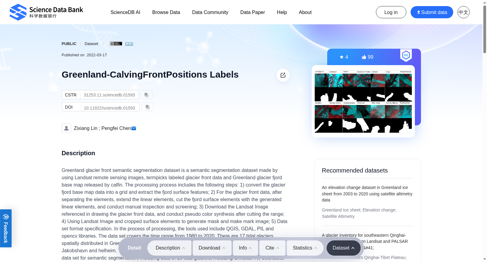
Greenland glacier front semantic segmentation dataset is a semantic segmentation dataset made by using Landsat remote sensing images, termpicks labeled glacier front data and Greenland glacier fjord base map released by calfin. The processing process includes the following steps: 1) convert the glacier fjord base map data into a grid and extract the fjord surface features; 2) For the glacier front data, after separating the elements, extend the linear elements, cut the fjord surface elements with the generated linear elements, and conduct manual inspection and screening; 3) Download the Landsat Image referenced in drawing the glacier front data, and conduct pseudo color synthesis after cutting the range; 4) Using Landsat Image and cropped surface elements to generate mask and make mark image; 5) Data set format specification. In the process of processing, the tools used include QGIS, GDAL, PIL and opencv libraries. The data set covers the time range from 1980 to 2020. There are 17 tidal glaciers spatially distributed in Greenland, including glaciers with large disintegration changes such as Jakobshavn and helheim. The dataset contains three subfolders, among which glacier_Train is a sample data set for semantic segmentation, including data of 16 tidal glaciers, including Christian IV, Courtauld, Fenris, Glacier de France, Helheim, Inngia, Kangerlussuaq, Kangerlussuup, Midgard, Narsap Sermia, Nunakassaap, Peterman, Rink ibrae, Sermeq Silarleq, Spaltegletsjer and Umiammakku, There are two types of data sizes, 256 * 256 and 512 * 512 respectively. The data size is determined according to the width and coverage of tidal glaciers. Glacier_Validation is a sample data set used to verify the performance of the semantic segmentation network after training, including the data of Jakobshavn Glacier. Glacier_Deeplab is a sample data set in the format required for semantic segmentation after sample enhancement. The transformed remote sensing image and labeled image are PNG data, in which the labeled image is normalized to divide the foreground and background into different pixels.
格陵兰冰川前缘语义分割数据集是一套基于陆地卫星(Landsat)遥感影像、经termpicks标注的冰川前缘数据,以及由calfin发布的格陵兰冰川峡湾底图构建的语义分割数据集。其处理流程包含以下步骤:1)将冰川峡湾底图数据转换为栅格并提取峡湾地表特征;2)针对冰川前缘数据,先分离要素再延展线性要素,利用生成的线性要素裁切峡湾地表要素,并开展人工核查与筛选;3)下载冰川前缘数据标注时所参考的Landsat影像,裁切影像范围后进行伪彩色合成;4)利用Landsat影像与裁切后的地表要素生成掩码并制作标记图像;5)遵循数据集格式规范。处理过程中使用的工具包括QGIS、GDAL、PIL与OpenCV库。该数据集的时间覆盖范围为1980年至2020年,空间上分布于格陵兰岛的17条潮汐冰川,涵盖雅各布港(Jakobshavn)、黑尔海姆(Helheim)等发生过大规模崩解变化的冰川。数据集包含三个子文件夹:其中Glacier_Train为语义分割训练样本数据集,包含16条潮汐冰川的数据,具体包括克里斯蒂安四世(Christian IV)、科陶尔德(Courtauld)、芬里斯(Fenris)、法国冰川(Glacier de France)、黑尔海姆(Helheim)、英吉亚(Inngia)、康格鲁苏阿克(Kangerlussuaq)、康格鲁苏普(Kangerlussuup)、米德加德(Midgard)、纳萨普塞尔米亚(Narsap Sermia)、努纳卡萨普(Nunakassaap)、彼德曼(Peterman)、Rink ibrae、塞尔梅克西拉勒克(Sermeq Silarleq)、斯帕特莱冰川(Spaltegletsjer)与乌米阿姆库(Umiammakku)。数据尺寸分为256×256与512×512两种,根据潮汐冰川的宽度与覆盖范围确定。Glacier_Validation为用于验证训练后语义分割网络性能的样本数据集,仅包含雅各布港冰川的数据。Glacier_Deeplab为经样本增强后符合语义分割要求格式的样本数据集。经转换的遥感影像与标记图像均为PNG格式数据,其中标记图像经归一化处理,将前景与背景划分为不同像素值。
创建时间:
2024-01-31
搜集汇总
数据集介绍
背景与挑战
背景概述
该数据集是一个基于Landsat遥感影像的格陵兰冰川前缘语义分割数据集,覆盖1980年至2020年的时间范围和17个格陵兰潮汐冰川,包括Jakobshavn等变化显著的冰川。数据集包含训练、验证和样本增强子集,数据格式为PNG图像,标注图像经过归一化处理,适用于冰川前缘位置的语义分割研究。
以上内容由遇见数据集搜集并总结生成


