青藏高原AVHRR轨道漂移纠正地表温度产品(0.05度)
收藏国家青藏高原科学数据中心2024-09-26 更新2024-10-19 收录
下载链接:
https://data.tpdc.ac.cn/zh-hans/data/56e4cbb4-bd23-42db-ab3c-6ff8a0995f83
下载链接
链接失效反馈官方服务:
资源简介:
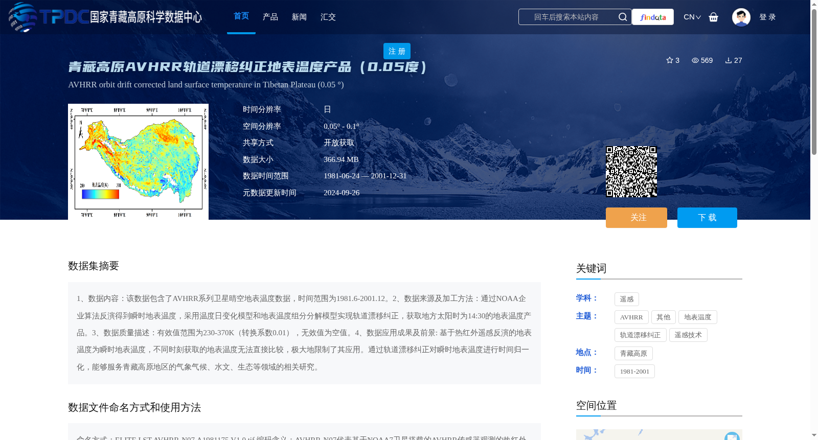
1、数据内容:该数据包含了AVHRR系列卫星晴空地表温度数据,时间范围为1981.6-2001.12。2、数据来源及加工方法:通过NOAA企业算法反演得到瞬时地表温度,采用温度日变化模型和地表温度组分分解模型实现轨道漂移纠正,获取地方太阳时为14:30的地表温度产品。3、数据质量描述:有效值范围为230-370K(转换系数0.01),无效值为空值。4、数据应用成果及前景: 基于热红外遥感反演的地表温度为瞬时地表温度,不同时刻获取的地表温度无法直接比较,极大地限制了其应用。通过轨道漂移纠正对瞬时地表温度进行时间归一化,能够服务青藏高原地区的气象气候、水文、生态等领域的相关研究。
1. Data Content: This dataset contains clear-sky land surface temperature (LST) data from the AVHRR series satellites, with a temporal coverage from June 1981 to December 2001.
2. Data Source and Processing Method: Instantaneous land surface temperature is retrieved using NOAA's enterprise algorithms. Orbit drift correction is implemented via the diurnal temperature variation model and land surface temperature component decomposition model to produce land surface temperature products corresponding to local solar time 14:30.
3. Data Quality Description: The valid value range is 230–370 K, with a conversion coefficient of 0.01 for converting stored digital values to actual temperature measurements, and invalid values are represented as null values.
4. Data Application Achievements and Prospects: Land surface temperature retrieved via thermal infrared remote sensing is inherently instantaneous, so LST data acquired at different times cannot be directly compared, which greatly restricts its application. Temporal normalization of instantaneous land surface temperature through orbit drift correction can support relevant research in fields such as meteorology, climatology, hydrology and ecology in the Qinghai-Tibet Plateau region.
提供机构:
孟翔晨,刘伟汉,王鹤霖,程洁,施建成
创建时间:
2024-09-25
搜集汇总
数据集介绍
背景与挑战
背景概述
该数据集是青藏高原地区基于AVHRR卫星数据的轨道漂移纠正地表温度产品,时间覆盖1981年至2001年,空间分辨率为0.05度,提供日尺度的地方太阳时14:30地表温度数据。通过NOAA企业算法反演和模型纠正,实现了时间归一化,有效支持气象气候、水文和生态等领域的科学研究。
以上内容由遇见数据集搜集并总结生成


