泛第三极65国1km分辨率土壤侵蚀强度数据集(2015)
收藏地球大数据科学工程2024-03-04 收录
下载链接:
https://data.casearth.cn/sdo/detail/5feae826819aec33049b7c44
下载链接
链接失效反馈官方服务:
资源简介:
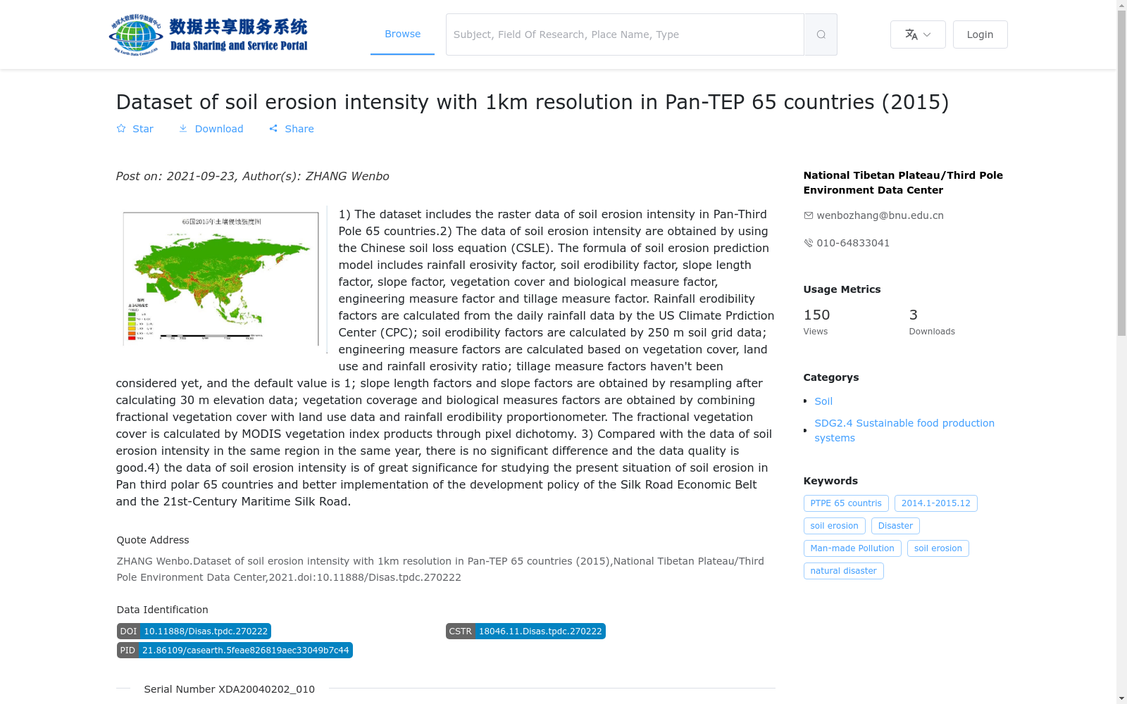
1)数据内容包含泛第三极65国区域土壤侵蚀强度栅格数据。2)土壤侵蚀强度数据采用中国土壤侵蚀预报模型(CSLE)计算获取。土壤侵蚀预报模型公式中包含降雨侵蚀力因子、土壤可蚀性因子、坡长因子、坡度因子、植被覆盖与生物措施因子、工程措施因子、耕作措施因子。65国降雨侵蚀力因子由美国气候预测中心(CPC)发布的日降雨量产品计算获得;土壤可蚀性因子采用250mSoilGrid网格土壤数据计算;耕作措施因子利用植被覆盖度结合土地利用和降雨侵蚀力比例计算;工程措施初稿暂未考虑,暂时取值为1;坡长因子、坡度因子通过30m高程数据计算后重采样得到;植被覆盖与生物措施因子由植被覆盖度结合土地利用数据和降雨侵蚀力比例计算得出,其中植被覆盖度是由MODIS的植被指数产品通过像元二分法计算得到。3)通过和同年同区域已有土壤侵蚀强度数据对比,无明显差异,数据质量良好。4)土壤侵蚀强度数据对研究泛第三极65国土壤侵蚀现状,更好的贯彻“一带一路”发展政策具有重要的意义。
1) The dataset contains raster data of soil erosion intensity across the 65 countries in the Pan-third Pole region.
2) The soil erosion intensity data was calculated using the Chinese Soil Loss Equation (CSLE). The CSLE includes seven core factors: rainfall erosivity factor, soil erodibility factor, slope length factor, slope steepness factor, vegetation cover and biological measure factor, engineering measure factor, and tillage measure factor. Specifically, the rainfall erosivity factor for the 65 countries was computed from the daily rainfall product released by the U.S. Climate Prediction Center (CPC); the soil erodibility factor was calculated using 250m SoilGrid grid soil data; the tillage measure factor was derived by combining vegetation coverage, land use data and the rainfall erosivity ratio; the engineering measure factor was not considered in the initial draft and was temporarily assigned a value of 1; the slope length factor and slope steepness factor were calculated from 30m elevation data and then resampled; the vegetation cover and biological measure factor was calculated based on vegetation coverage, land use data and the rainfall erosivity ratio, where the vegetation coverage was obtained from MODIS vegetation index products via the dimidiate pixel model.
3) No significant differences were observed when compared with existing soil erosion intensity data from the same region and year, confirming the good quality of this dataset.
4) This soil erosion intensity dataset is of great significance for studying the current status of soil erosion in the 65 Pan-third Pole countries and better implementing the development policies of the Belt and Road Initiative.
提供机构:
国家青藏高原科学数据中心
搜集汇总
数据集介绍
背景与挑战
背景概述
该数据集提供了2015年泛第三极65个国家1公里分辨率的土壤侵蚀强度栅格数据,采用中国土壤流失方程(CSLE)计算,综合考虑降雨侵蚀力、土壤可蚀性、坡度长度和植被覆盖等多个因子,数据质量可靠。它对于评估区域土壤侵蚀现状和支持“一带一路”发展政策具有重要应用价值。
以上内容由遇见数据集搜集并总结生成


