中国1km分辨率生物气候要素空间分布数据集
收藏Mendeley Data2024-01-31 更新2024-06-27 收录
下载链接:
https://www.scidb.cn/en/detail?dataSetId=1a49c4e2a58c443095d38ca60a7f023a
下载链接
链接失效反馈官方服务:
资源简介:
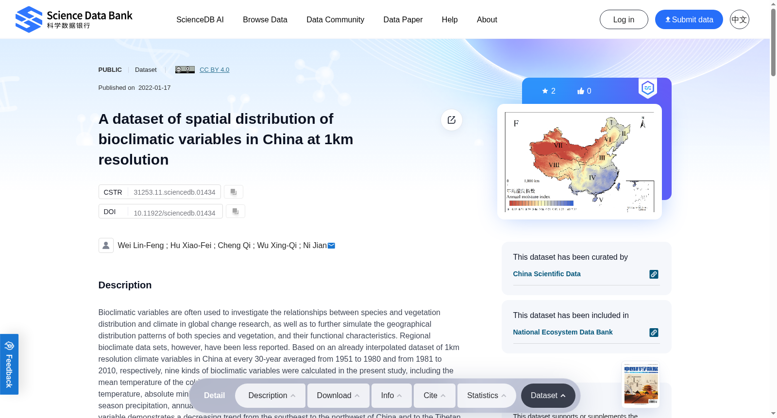
Bioclimatic variables are often used to investigate the relationships between species and vegetation distribution and climate in global change research, as well as to further simulate the geographical distribution patterns of both species and vegetation, and their functional characteristics. Regional bioclimate data sets, however, have been less reported. Based on an already interpolated dataset of 1km resolution climate variables in China at every 30-year averaged from 1951 to 1980 and from 1981 to 2010, respectively, nine kinds of bioclimatic variables were calculated in the present study, including the mean temperature of the coldest month, mean temperature of the warmest month, absolute maximum temperature, absolute minimum temperature, annual growing degree days above 0°C and 5°C, growing season precipitation, annual drought index and annual moisture index. Results show that every bioclimate variable demonstrates a decreasing trend from the southeast to the northwest of China and to the Tibetan Plateau except mean temperature of the warmest month and absolute maximum temperature, and varies greatly in different vegetation regions. An overall upward trend of bioclimatic change existed between 1951-1980 and 1981-2010, but such increase was small. This dataset provides reasonable environmentally mechanistic explanations for research on the relationships between species and vegetation and climate, and offers a convenient and diverse way for researchers to use bioclimatic variables to simulate species distribution pattern and vegetation structure and functions.Nine 1km spatial resolution bioclimatic variables datasets from 1951-1980 and 1981-2010 were deposited in two folders ( Appendix I and II ), 1951-1980 and 1981-2010, respectively, with the following naming rules : China-S-X-1km.Z. S Represents the years (1951-1980/1981-2010). X represents the bioclimatic variables, Z represents the format of the data, respectively, two-dimensional uniform grid format (.grd ), ASCII character set encoding text file format (.asc ) and tag image file format (.tif ). In this way, this dataset has three sets of formats that can be used for different research objectives. In addition, the image file format for each variable (.jpg ) is provided for ease of access.
生物气候变量(bioclimatic variables)在全球变化研究中常被用于探究物种、植被分布与气候之间的关联,同时可进一步模拟物种与植被的地理分布格局及其功能特征。然而,区域尺度的生物气候数据集相关报道较为少见。本研究基于两套已完成插值的1千米分辨率气候变量数据集,分别为1951-1980年与1981-2010年的30年平均气候数据,计算得到九类生物气候变量,包括最冷月平均气温、最暖月平均气温、绝对最高气温、绝对最低气温、≥0℃与≥5℃的年生长度日数、生长季降水量、年干旱指数与年湿润指数。研究结果显示,除最暖月平均气温与绝对最高气温外,其余各类生物气候变量均呈现出从中国东南地区向西北地区及青藏高原逐渐降低的趋势,且在不同植被区域间差异显著。1951-1980年至1981-2010年间,生物气候整体呈现小幅上升的变化趋势。本数据集为物种、植被与气候之间关联的相关研究提供了合理的环境机制解释,同时为科研人员利用生物气候变量模拟物种分布格局、植被结构与功能提供了便捷多样的研究途径。两套分别对应1951-1980年与1981-2010年的1千米分辨率生物气候变量数据集分别存储于两个文件夹(附录I与附录II)中,命名规则如下:"China-S-X-1km.Z"。其中S代表年份区间(1951-1980/1981-2010),X代表生物气候变量类型,Z代表数据格式,具体包含二维均匀网格格式(.grd)、ASCII字符编码文本文件格式(.asc)与标记图像文件格式(.tif)三类,可适配不同的研究目标。此外,本数据集还提供了各变量的.jpg格式图像文件以方便查阅。
创建时间:
2024-01-31
搜集汇总
数据集介绍
背景与挑战
背景概述
该数据集提供了中国1951-2010年间1km分辨率的9种生物气候变量空间分布数据,适用于物种与气候关系研究及分布模拟。数据以多种格式存储,便于不同研究需求使用。
以上内容由遇见数据集搜集并总结生成


