SSS SMOS/SMAP OI L4 maps
收藏DataCite Commons2025-05-16 更新2025-04-16 收录
下载链接:
http://www.seanoe.org/data/00619/73142/
下载链接
链接失效反馈资源简介:
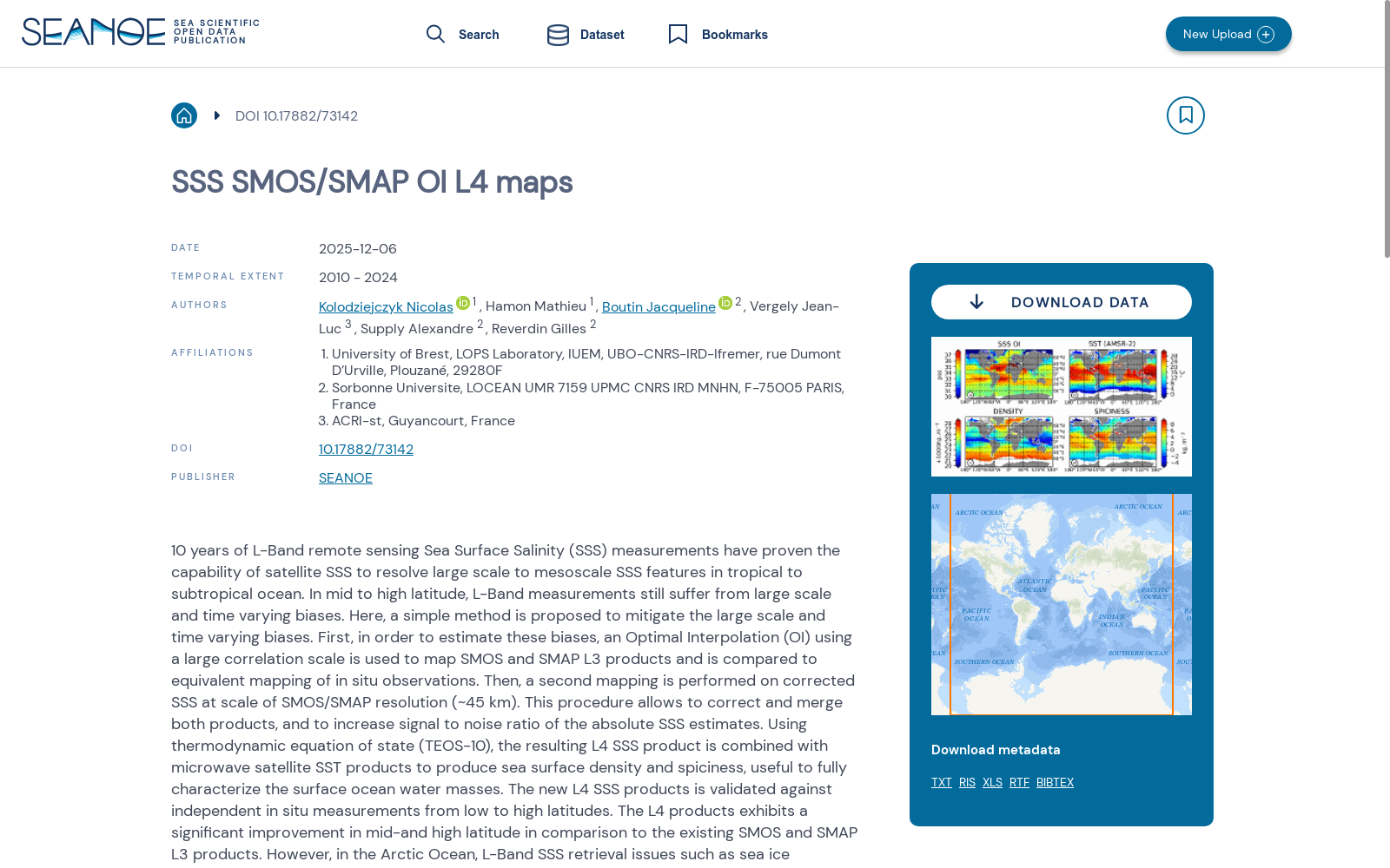
10 years of L-Band remote sensing Sea Surface Salinity (SSS) measurements have proven the capability of satellite SSS to resolve large scale to mesoscale SSS features in tropical to subtropical ocean. In mid to high latitude, L-Band measurements still suffer from large scale and time varying biases. Here, a simple method is proposed to mitigate the large scale and time varying biases. First, in order to estimate these biases, an Optimal Interpolation (OI) using a large correlation scale is used to map SMOS and SMAP L3 products and is compared to equivalent mapping of in situ observations. Then, a second mapping is performed on corrected SSS at scale of SMOS/SMAP resolution (~45 km). This procedure allows to correct and merge both products, and to increase signal to noise ratio of the absolute SSS estimates. Using thermodynamic equation of state (TEOS-10), the resulting L4 SSS product is combined with microwave satellite SST products to produce sea surface density and spiciness, useful to fully characterize the surface ocean water masses. The new L4 SSS products is validated against independent in situ measurements from low to high latitudes. The L4 products exhibits a significant improvement in mid-and high latitude in comparison to the existing SMOS and SMAP L3 products. However, in the Arctic Ocean, L-Band SSS retrieval issues such as sea ice contamination and low sensitivity in cold water are still challenging to improve L-Band SSS data.
十年的L波段遥感海表盐度(Sea Surface Salinity, SSS)观测数据已证实,卫星遥感SSS具备解析热带至亚热带海洋中大尺度到中尺度SSS特征的能力。在中高纬度区域,L波段观测仍存在大尺度且随时间变化的偏差。本文提出一种简单方法以抑制此类大尺度、时变偏差。首先,为估算此类偏差,本文采用大相关尺度的最优插值(Optimal Interpolation, OI)方法对SMOS与SMAP的L3级产品进行制图,并将结果与原位(in situ)观测的等效制图结果进行对比。随后,以SMOS/SMAP的分辨率(约45千米)为基准尺度,对校正后的SSS开展第二次制图。该流程可实现两款产品的校正与融合,并提升绝对SSS反演结果的信噪比。利用热力学状态方程(TEOS-10),将生成的L4级SSS产品与微波卫星海表温度(Sea Surface Temperature, SST)产品相结合,可得到海表密度与温盐锐度,用于完整表征表层海洋水团属性。该新型L4级SSS产品借助取自低纬至高纬的独立原位观测数据完成了验证。与现有SMOS、SMAP的L3级产品相比,该L4级产品在中高纬度区域的表现有显著提升。然而在北冰洋区域,L波段SSS反演仍存在海冰污染、冷水环境下灵敏度偏低等问题,对L波段SSS数据的优化仍构成挑战。
提供机构:
SEANOE
创建时间:
2020-04-07
AI搜集汇总
数据集介绍
背景与挑战
背景概述
该数据集是一个L4级海表盐度(SSS)产品,结合了SMOS和SMAP卫星的观测数据,时间覆盖2010年至2024年,全球范围从89°N到89°S。它采用最优插值方法校正了卫星数据中的大尺度和时间变化偏差,并整合海表温度数据以生成海表密度和spiciness,旨在提高中高纬度地区的精度,但在北极地区仍受海冰污染和低温敏感性问题限制。
以上内容由AI搜集并总结生成


