High-Quality Hallucination Benchmark (HQH)|视觉-语言模型数据集|模型评估数据集
收藏数据集概述
数据集名称
HQH Benchmark
数据集描述
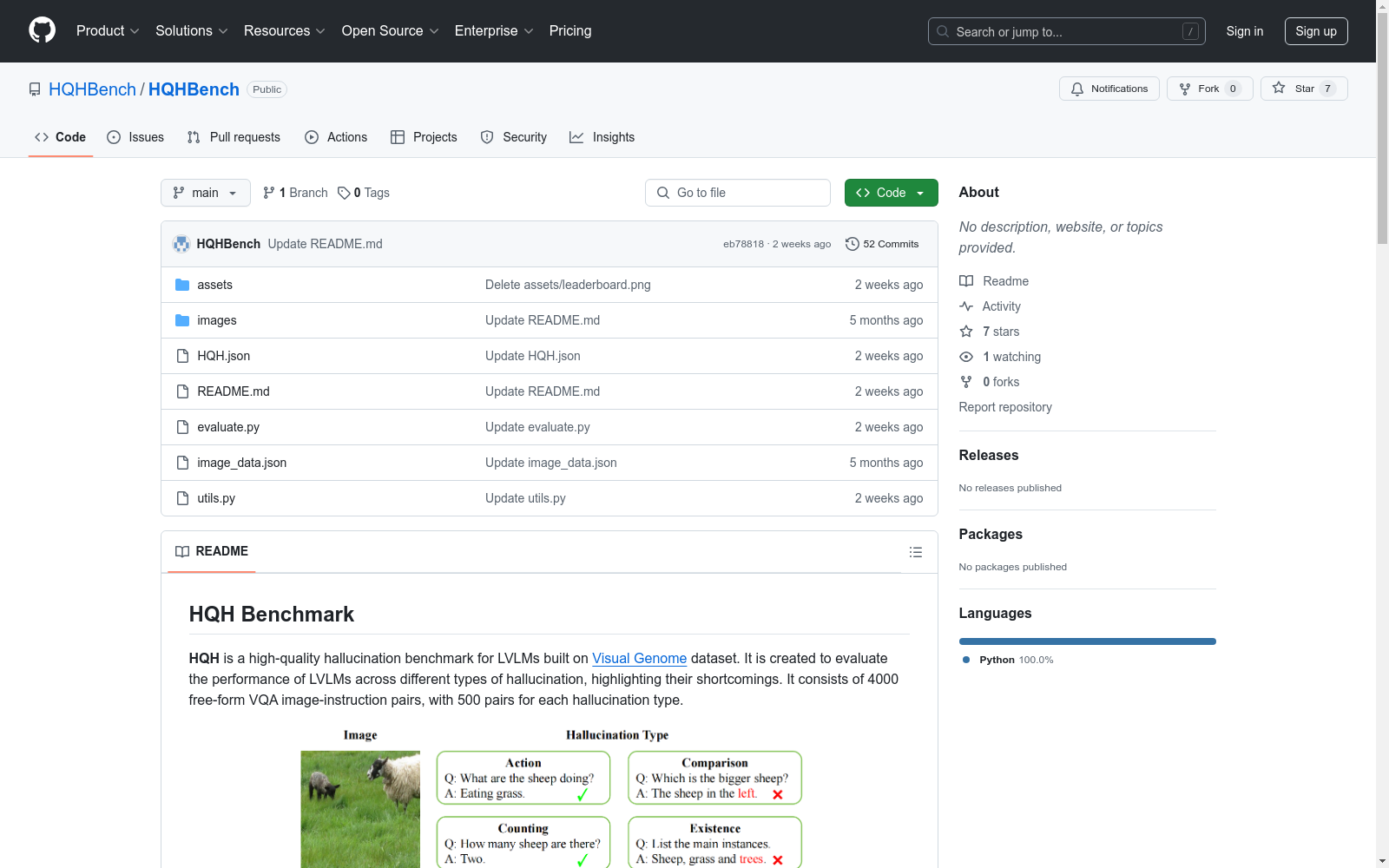
HQH 是一个高质量的幻觉基准测试数据集,专为大型视觉-语言模型(LVLMs)设计。该数据集基于 Visual Genome 数据集构建,旨在评估 LVLMs 在不同类型的幻觉问题上的表现,并突出其不足之处。数据集包含 1600 个自由形式的视觉问答(VQA)图像-指令对,每种幻觉类型有 200 对。
数据结构
数据集文件 HQH.json
的格式如下:
python [ {"id": 1, "image_id": 150494, "image": "./images/150494.jpg", "instruction": "What is the man in a suit doing?", "ground_truth": "Giving a speech.", "type": "action"}, ... ]
其中:
id
:数据在 HQH 中的标识符。image_id
:图像在 Visual Genome 中的标识符。image
:图像路径。instruction
:指令。ground_truth
:标准答案。type
:幻觉类型。
数据下载
图像可以从 此链接 下载。图像注释保存在 image_data.json
文件中。
评估方法
使用 GPT-3.5 计算幻觉率作为评估指标。评估代码在 evaluate.py
中提供,运行方式如下:
python python evaluate.py --ans_file path/to/your/answer/file --openai_key your/openai/api/key --num model/num/for/evaluation
LVLMs 的答案应组织在一个 JSON 文件中,格式如下:
python [ {"id": 1, "image_id": 150494, "image": "./images/150494.jpg", "instruction": "What is the man in a suit doing?", "ground_truth": "Giving a speech.", "type": "action", "answers": ["The man in the suit is giving a speech to a group of soldiers.",...]}, ... ]
即在 HQH.json
的每个实例中添加一个 "answers" 字段。

中国气象数据
本数据集包含了中国2023年1月至11月的气象数据,包括日照时间、降雨量、温度、风速等关键数据。通过这些数据,可以深入了解气象现象对不同地区的影响,并通过可视化工具揭示中国的气温分布、降水情况、风速趋势等。
github 收录
中国1km分辨率逐月降水量数据集(1901-2023)
该数据集为中国逐月降水量数据,空间分辨率为0.0083333°(约1km),时间为1901.1-2023.12。数据格式为NETCDF,即.nc格式。该数据集是根据CRU发布的全球0.5°气候数据集以及WorldClim发布的全球高分辨率气候数据集,通过Delta空间降尺度方案在中国降尺度生成的。并且,使用496个独立气象观测点数据进行验证,验证结果可信。本数据集包含的地理空间范围是全国主要陆地(包含港澳台地区),不含南海岛礁等区域。为了便于存储,数据均为int16型存于nc文件中,降水单位为0.1mm。 nc数据可使用ArcMAP软件打开制图; 并可用Matlab软件进行提取处理,Matlab发布了读入与存储nc文件的函数,读取函数为ncread,切换到nc文件存储文件夹,语句表达为:ncread (‘XXX.nc’,‘var’, [i j t],[leni lenj lent]),其中XXX.nc为文件名,为字符串需要’’;var是从XXX.nc中读取的变量名,为字符串需要’’;i、j、t分别为读取数据的起始行、列、时间,leni、lenj、lent i分别为在行、列、时间维度上读取的长度。这样,研究区内任何地区、任何时间段均可用此函数读取。Matlab的help里面有很多关于nc数据的命令,可查看。数据坐标系统建议使用WGS84。
国家青藏高原科学数据中心 收录
中国空气质量数据集(2014-2020年)
数据集中的空气质量数据类型包括PM2.5, PM10, SO2, NO2, O3, CO, AQI,包含了2014-2020年全国360个城市的逐日空气质量监测数据。监测数据来自中国环境监测总站的全国城市空气质量实时发布平台,每日更新。数据集的原始文件为CSV的文本记录,通过空间化处理生产出Shape格式的空间数据。数据集包括CSV格式和Shape格式两数数据格式。
国家地球系统科学数据中心 收录
PROSLU
PROSLU数据集是由哈尔滨工业大学社会计算与信息检索研究中心和华为技术有限公司共同创建的,包含超过5000条中文语句,每条语句都配有详细的个人资料信息,如知识图谱、用户资料和上下文感知信息。数据集通过人工标注确保高质量,旨在解决在语义模糊的实际场景中,传统基于文本的口语理解模型可能无法准确识别意图和槽位的问题。该数据集的应用领域主要集中在提高对话系统在复杂环境下的理解和响应能力,特别是在用户意图不明确或语句具有多重含义的情况下。
arXiv 收录
全国 1∶200 000 数字地质图(公开版)空间数据库
As the only one of its kind, China National Digital Geological Map (Public Version at 1∶200 000 scale) Spatial Database (CNDGM-PVSD) is based on China' s former nationwide measured results of regional geological survey at 1∶200 000 scale, and is also one of the nationwide basic geosciences spatial databases jointly accomplished by multiple organizations of China. Spatially, it embraces 1 163 geological map-sheets (at scale 1: 200 000) in both formats of MapGIS and ArcGIS, covering 72% of China's whole territory with a total data volume of 90 GB. Its main sources is from 1∶200 000 regional geological survey reports, geological maps, and mineral resources maps with an original time span from mid-1950s to early 1990s. Approved by the State's related agencies, it meets all the related technical qualification requirements and standards issued by China Geological Survey in data integrity, logic consistency, location acc racy, attribution fineness, and collation precision, and is hence of excellent and reliable quality. The CNDGM-PVSD is an important component of China' s national spatial database categories, serving as a spatial digital platform for the information construction of the State's national economy, and providing informationbackbones to the national and provincial economic planning, geohazard monitoring, geological survey, mineral resources exploration as well as macro decision-making.
DataCite Commons 收录