格陵兰500m分辨率DEM(2019年5月)
收藏国家青藏高原科学数据中心2022-04-15 更新2024-03-06 收录
下载链接:
https://data.tpdc.ac.cn/zh-hans/data/07497631-0475-48b5-ba53-c17f9076c72f
下载链接
链接失效反馈官方服务:
资源简介:
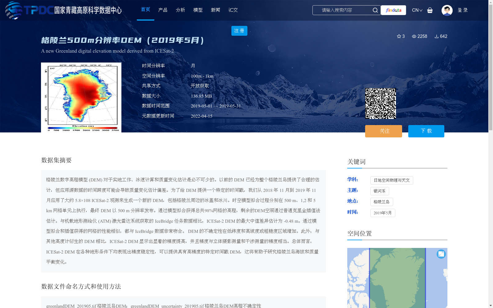
格陵兰数字高程模型 (DEM) 对于实地工作、冰速计算和质量变化估计是必不可少的。以前的 DEM 已经为整个格陵兰岛提供了合理的估计,但应用源数据的时间跨度可能会导致质量变化估计偏差。为了给 DEM 提供一个特定的时间戳,我们从 2018 年 11 月到 2019 年 11 月应用了大约 5.8×10⁸ ICESat-2 观测来生成一个新的 DEM,包括格陵兰周边的冰盖和冰川。时空模型拟合过程分别在 500 m、1,2 和 5 km 网格单元上执行,最终 DEM 以 500 m 分辨率发布。通过模型拟合获得总共98%网格的高程,剩余的DEM空洞通过普通克里金插值法估计。与机载地形测绘仪 (ATM) 激光雷达系统获取的 IceBridge 任务数据相比,ICESat-2 DEM 的最大中值差异估计为 -0.48 m。通过模型拟合和插值获得的网格的性能相似,都与 IceBridge 数据非常吻合。 DEM 的不确定性在低纬度和高坡度或粗糙度区域增加。此外,与其他高度计衍生的 DEM 相比,ICESat-2 DEM 显示出显着的精度提高,并且精度与立体摄影测量和干涉测量的精度相当。总体而言,ICESat-2 DEM 在各种地形条件下均表现出精度稳定性,可以提供具有高精度的特定时间戳 DEM,这将有助于研究格陵兰岛海拔和质量平衡变化。
The Greenland Digital Elevation Model (DEM) is essential for fieldwork, ice velocity calculation, and mass change estimation. Previous DEMs have provided reasonable estimates for the entire Greenland Ice Sheet, but the temporal span of their source data may introduce biases in mass change estimates. To generate a DEM with a specific timestamp, we produced a new DEM covering the Greenland Ice Sheet and surrounding glaciers using approximately 5.8×10^8 ICESat-2 observations collected between November 2018 and November 2019. The spatiotemporal model fitting was conducted on 500 m, 1 km, and 5 km grid cells separately, and the final DEM was released at a 500 m resolution. Elevations for 98% of the total grid cells were obtained via model fitting, and the remaining DEM voids were interpolated using ordinary kriging. Compared with IceBridge mission data acquired by the Airborne Topographic Mapper (ATM) LiDAR system, the maximum median difference of the ICESat-2 DEM is estimated at -0.48 m. Grid cells derived from model fitting and interpolation exhibit comparable performance, both aligning closely with the IceBridge data. The DEM's uncertainty increases in low-latitude regions as well as areas with steep slopes or high surface roughness. Furthermore, relative to other altimeter-derived DEMs, the ICESat-2 DEM delivers notable accuracy improvements, with its precision matching that of stereophotogrammetry and interferometry. Overall, the ICESat-2 DEM maintains consistent accuracy across diverse topographic conditions, offering a high-precision, timestamped DEM that will facilitate research on elevation and mass balance changes of the Greenland Ice Sheet.
提供机构:
范宇宾,柯长青,沈校熠
创建时间:
2021-05-27
搜集汇总
数据集介绍
背景与挑战
背景概述
该数据集是一个基于ICESat-2观测生成的格陵兰岛数字高程模型(DEM),分辨率为500米,时间范围为2019年5月,覆盖格陵兰冰盖和冰川。它通过模型拟合和插值方法处理,具有高精度,适用于实地工作、冰速计算和质量变化估计等研究,并以开放获取方式共享。
以上内容由遇见数据集搜集并总结生成


