大湖塘莫霍面深度和Vp/Vs
收藏国家青藏高原科学数据中心2021-06-11 更新2024-03-01 收录
下载链接:
https://data.tpdc.ac.cn/zh-hans/data/3cbb9c2c-85e6-4ce7-9f69-078678cc39fe
下载链接
链接失效反馈官方服务:
资源简介:
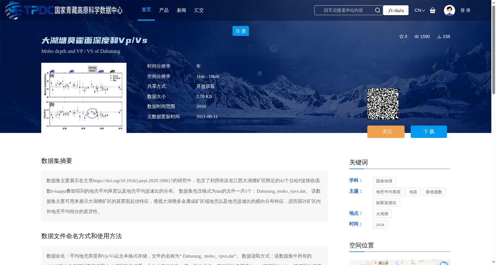
数据集主要展示在文章https://doi.org/10.1016/j.pepi.2020.106617的研究中,包含了利用布设在江西大湖塘矿区附近的42个台站P波接收函数h-kappa叠加得到的地壳平均厚度以及地壳平均波速比的分布。
数据集包含格式为dat的文件一共1个:Dahutang_moho_vpvs.dat。
该数据集主要可用来展示大湖塘矿区的莫霍面起伏特征,透视大湖塘多金属成矿区域地壳以及地壳波速比的横向分布特征,进而探讨矿区内外地壳平均组分的差异性。
This dataset originates from the study published in the article at https://doi.org/10.1016/j.pepi.2020.106617, and contains the distributions of average crustal thickness and average crustal Vp/Vs ratio derived from P-wave receiver function h-κ stacking using 42 seismic stations deployed near the Dahutang mining area, Jiangxi Province.
The dataset includes exactly one file in .dat format, named Dahutang_moho_vpvs.dat.
This dataset is primarily applicable to visualize the undulation features of the Moho beneath the Dahutang mining area, reveal the lateral distribution characteristics of the crust and crustal Vp/Vs ratio in the Dahutang polymetallic metallogenic region, and further investigate the differences in average crustal compositions between the inside and outside of the mining area.
提供机构:
邓阳凡
创建时间:
2021-05-23
搜集汇总
数据集介绍
背景与挑战
背景概述
该数据集包含江西大湖塘矿区的地壳厚度和波速比测量数据,基于42个地震台站的观测结果,以DAT格式存储,可用于分析矿区地壳结构和组分特征。数据来源于2018年研究,空间分辨率1-10公里,包含台站坐标和质量控制标志等详细信息。
以上内容由遇见数据集搜集并总结生成


