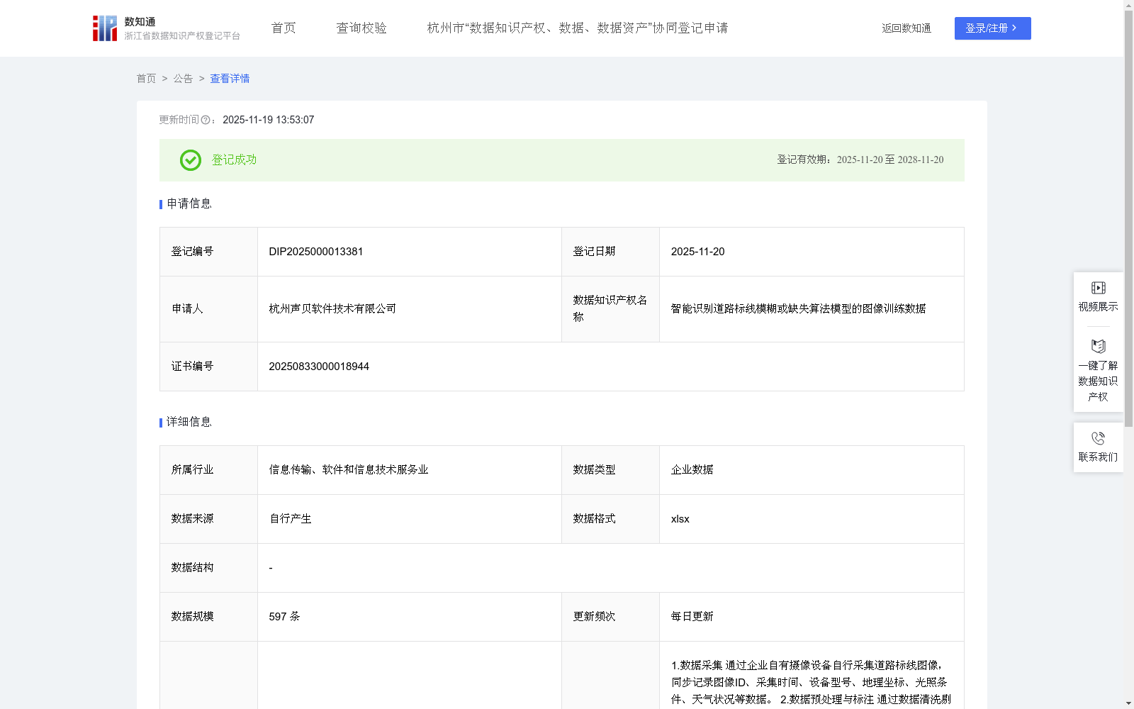
智能识别道路标线模糊或缺失算法模型的图像训练数据
收藏浙江省数据知识产权登记平台2025-11-19 更新2025-11-26 收录
下载链接:
https://www.zjip.org.cn/home/announce/trends/8402407
下载链接
链接失效反馈官方服务:
资源简介:
本数据集主要用于提升AI模型对道路标线模糊、缺失等异常状态的识别能力与精确性。通过对该数据集的训练,使AI模型能够通过图像分析精准识别标线模糊、缺失、覆盖等异常情况,并可应用于市政道路维护、高速公路巡检、智慧交通管理及施工质量验收等场景。同时,本数据集可为道路养护部门提供智能化巡检手段,优化养护资源分配;为高速公路管理降低人工巡检成本;为自动驾驶系统提供实时标线数据;为施工验收提供智能核查工具,从而全面提升道路安全管理水平和交通运行效率。
1.数据采集
通过企业自有摄像设备自行采集道路标线图像,同步记录图像ID、采集时间、设备型号、地理坐标、光照条件、天气状况等数据。
2.数据预处理与标注
通过数据清洗剔除模糊、过曝或严重遮挡图像。按7:2:1比例划分训练集/验证集/测试集。设置多级标注体系:
一级标签:正常标线/异常标线
二级标签:模糊/缺失/部分覆盖/反光异常/其他
辅助标注:异常区域边界框坐标、标线类型(车道线/停止线/转向箭头等)。
3.模型选择与初始化
采用YOLOv8预训练模型,初始化参数并优化超参数:学习率0.001-0.0001动态调整,批量大小1-32动态调整,锚框参数适配直线型标线特征;集成边缘检测模块增强模糊标线识别能力。
4.模型训练
基于PyTorch实施分布式训练,采用混合精度训练(FP16)提升效率。设置训练时长,数据增强模拟复杂道路场景,添加雨水反光、轮胎印记覆盖、树影遮挡等干扰,设置早停机制(patience=15)和梯度裁剪(max_norm=1.0)。
5.模型评估
在训练模型的过程中,使用验证集调整超参数,训练完成后在测试集上评估模型表现,评估指标包含:
基础性能指标:mAP@0.5、误报率
场景鲁棒性测试:暴雨天气检出率
并设置渐进式测试:清晰标线→渐变模糊标线,干燥路面→湿滑/积雪路面。
This dataset is primarily designed to enhance the recognition accuracy and capability of AI models for identifying abnormal road marking states such as blurred and missing markings. Training AI models on this dataset enables them to accurately identify abnormal situations including blurred, missing, partially covered road markings via image analysis, and can be applied to scenarios such as municipal road maintenance, highway inspection, intelligent traffic management and construction quality acceptance.
Meanwhile, this dataset provides intelligent inspection means for road maintenance departments to optimize the allocation of maintenance resources, reduces manual inspection costs for highway management, provides real-time marking data for autonomous driving systems, and offers intelligent verification tools for construction acceptance, thereby comprehensively improving road safety management levels and traffic operation efficiency.
1. Data Collection
Road marking images are collected independently using the enterprise's own camera equipment, with synchronized recording of data such as image ID, collection time, equipment model, geographic coordinates, lighting conditions and weather conditions.
2. Data Preprocessing and Annotation
Blurry, overexposed or severely occluded images are removed through data cleaning. The dataset is split into training/validation/test sets at a ratio of 7:2:1. A multi-level annotation system is established:
- Primary label: Normal marking / Abnormal marking
- Secondary label: Blurred / Missing / Partially covered / Abnormal reflectivity / Others
- Auxiliary annotations: Coordinates of abnormal region bounding boxes, marking types (lane lines, stop lines, turning arrows, etc.).
3. Model Selection and Initialization
A pre-trained YOLOv8 model is adopted, with initialization parameters and optimized hyperparameters: dynamically adjusted learning rate (0.001-0.0001), dynamically adjusted batch size (1-32), anchor box parameters adapted to the characteristics of linear markings; an edge detection module is integrated to enhance the recognition ability of blurred markings.
4. Model Training
Distributed training is implemented based on PyTorch, with mixed-precision training (FP16) adopted to improve efficiency. Training duration is set, and data augmentation is used to simulate complex road scenarios, adding disturbances such as rain reflections, tire track coverage and tree shadow occlusion. An early stopping mechanism (patience=15) and gradient clipping (max_norm=1.0) are configured.
5. Model Evaluation
During the model training process, the validation set is used to adjust hyperparameters. After training is completed, the model performance is evaluated on the test set. The evaluation metrics include:
- Basic performance metrics: mAP@0.5, false positive rate
- Scenario robustness test: Detection rate in heavy rain weather
Progressive testing is also set up: clear markings → gradually blurred markings, dry pavement → slippery/snow-covered pavement.
提供机构:
杭州声贝软件技术有限公司
创建时间:
2025-08-03
搜集汇总
数据集介绍
背景与挑战
背景概述
该数据集包含597条图像训练数据,用于训练AI模型识别道路标线的模糊、缺失等异常状态,提升市政道路维护和智慧交通管理的效率。数据每日更新,采用YOLOv8模型进行训练,并通过数据增强和评估指标优化模型性能,适用于多种实际场景如高速公路巡检和自动驾驶系统。
以上内容由遇见数据集搜集并总结生成


