全球无间隙1km日均地表温度数据集(2003-2018)
收藏国家青藏高原科学数据中心2024-11-14 更新2024-11-30 收录
下载链接:
https://data.tpdc.ac.cn/zh-hans/data/ad05b016-cdf1-4493-8673-fd32f8aa330d
下载链接
链接失效反馈官方服务:
资源简介:
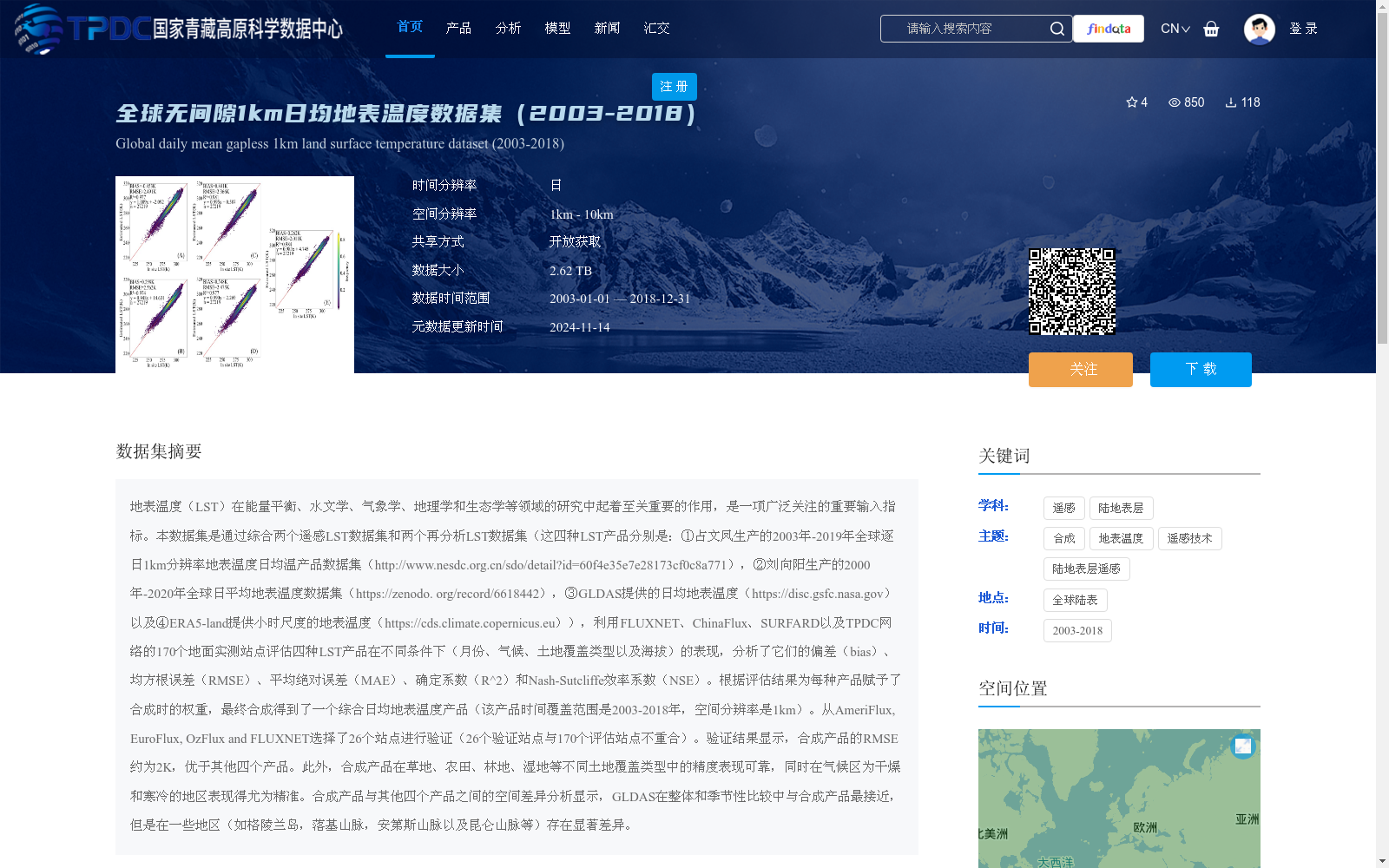
地表温度(LST)在能量平衡、水文学、气象学、地理学和生态学等领域的研究中起着至关重要的作用,是一项广泛关注的重要输入指标。本数据集是通过综合两个遥感LST数据集和两个再分析LST数据集(这四种LST产品分别是:①占文凤生产的2003年-2019年全球逐日1km分辨率地表温度日均温产品数据集(http://www.nesdc.org.cn/sdo/detail?id=60f4e35e7e28173cf0c8a771),②刘向阳生产的2000年-2020年全球日平均地表温度数据集(https://zenodo. org/record/6618442),③GLDAS提供的日均地表温度(https://disc.gsfc.nasa.gov)以及④ERA5-land提供小时尺度的地表温度(https://cds.climate.copernicus.eu)),利用FLUXNET、ChinaFlux、SURFARD以及TPDC网络的170个地面实测站点评估四种LST产品在不同条件下(月份、气候、土地覆盖类型以及海拔)的表现,分析了它们的偏差(bias)、均方根误差(RMSE)、平均绝对误差(MAE)、确定系数(R^2)和Nash-Sutcliffe效率系数(NSE)。根据评估结果为每种产品赋予了合成时的权重,最终合成得到了一个综合日均地表温度产品(该产品时间覆盖范围是2003-2018年,空间分辨率是1km)。从AmeriFlux, EuroFlux, OzFlux and FLUXNET选择了26个站点进行验证(26个验证站点与170个评估站点不重合)。验证结果显示,合成产品的RMSE约为2K,优于其他四个产品。此外,合成产品在草地、农田、林地、湿地等不同土地覆盖类型中的精度表现可靠,同时在气候区为干燥和寒冷的地区表现得尤为精准。合成产品与其他四个产品之间的空间差异分析显示,GLDAS在整体和季节性比较中与合成产品最接近,但是在一些地区(如格陵兰岛,落基山脉,安第斯山脉以及昆仑山脉等)存在显著差异。
Land Surface Temperature (LST) plays a critical role in research fields including energy balance, hydrology, meteorology, geography and ecology, and serves as a widely concerned important input parameter. This dataset was developed by integrating two remote-sensing LST datasets and two reanalysis LST datasets. The four LST products are as follows: ① the global daily mean LST product dataset at 1 km spatial resolution from 2003 to 2019 produced by Zhan Wenfeng (http://www.nesdc.org.cn/sdo/detail?id=60f4e35e7e28173cf0c8a771); ② the global daily mean LST dataset from 2000 to 2020 produced by Liu Xiangyang (https://zenodo.org/record/6618442); ③ daily mean LST provided by GLDAS (https://disc.gsfc.nasa.gov); and ④ hourly LST provided by ERA5-land (https://cds.climate.copernicus.eu). We evaluated the performance of the four LST products under various conditions (including month, climate zone, land cover type and elevation) using 170 in-situ measurement sites from the FLUXNET, ChinaFlux, SURFARD and TPDC networks, and analyzed their bias, root mean square error (RMSE), mean absolute error (MAE), coefficient of determination (R²) and Nash-Sutcliffe efficiency coefficient (NSE). Based on the evaluation results, we assigned optimal weights to each product for fusion, and finally generated a fused daily mean LST product with a temporal coverage of 2003–2018 and a spatial resolution of 1 km. We selected 26 sites from AmeriFlux, EuroFlux, OzFlux and FLUXNET for validation, and these 26 validation sites are non-overlapping with the 170 evaluation sites. The validation results show that the fused product has a RMSE of approximately 2 K, outperforming all the four individual products. In addition, the fused product exhibits reliable accuracy across different land cover types such as grassland, cropland, forest and wetland, and performs particularly well in arid and cold climate zones. Spatial difference analysis between the fused product and the four individual products reveals that GLDAS is the closest to the fused product in overall and seasonal comparisons, but shows significant discrepancies in some regions such as Greenland, the Rocky Mountains, the Andes and the Kunlun Mountains.
提供机构:
潘鑫,丁旭,杨英宝
创建时间:
2024-05-24
搜集汇总
数据集介绍
背景与挑战
背景概述
该数据集是一个全球陆表无间隙的日均地表温度产品,覆盖2003年至2018年,空间分辨率为1公里。它通过综合四种遥感与再分析地表温度数据集,基于170个地面站点的评估结果进行加权合成,验证显示其均方根误差约为2K,优于原始产品,并在不同土地覆盖类型和干燥寒冷气候区表现精准。数据以TIF格式存储,总大小为2.62 TB,适用于能量平衡、水文学等多领域研究。
以上内容由遇见数据集搜集并总结生成


