2018年中国1km生态系统类型空间分布数据
收藏地球大数据科学工程2024-03-04 收录
下载链接:
https://data.casearth.cn/sdo/detail/636e17eb819aec5df66b5199
下载链接
链接失效反馈官方服务:
资源简介:
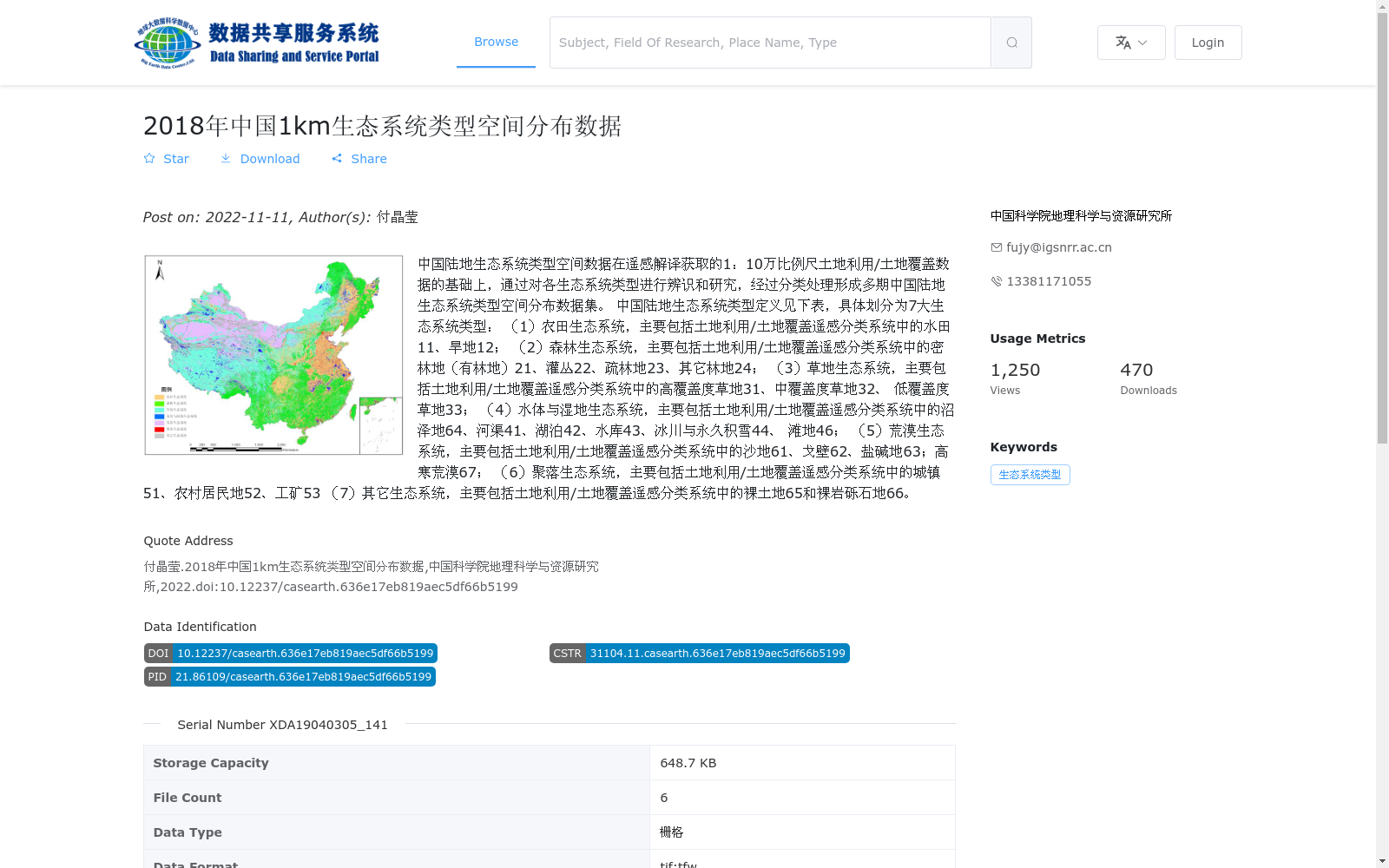
中国陆地生态系统类型空间数据在遥感解译获取的1:10万比例尺土地利用/土地覆盖数据的基础上,通过对各生态系统类型进行辨识和研究,经过分类处理形成多期中国陆地生态系统类型空间分布数据集。
中国陆地生态系统类型定义见下表,具体划分为7大生态系统类型:
(1)农田生态系统,主要包括土地利用/土地覆盖遥感分类系统中的水田11、旱地12;
(2)森林生态系统,主要包括土地利用/土地覆盖遥感分类系统中的密林地(有林地)21、灌丛22、疏林地23、其它林地24;
(3)草地生态系统,主要包括土地利用/土地覆盖遥感分类系统中的高覆盖度草地31、中覆盖度草地32、 低覆盖度草地33;
(4)水体与湿地生态系统,主要包括土地利用/土地覆盖遥感分类系统中的沼泽地64、河渠41、湖泊42、水库43、冰川与永久积雪44、 滩地46;
(5)荒漠生态系统,主要包括土地利用/土地覆盖遥感分类系统中的沙地61、戈壁62、盐碱地63;高寒荒漠67;
(6)聚落生态系统,主要包括土地利用/土地覆盖遥感分类系统中的城镇51、农村居民地52、工矿53
(7)其它生态系统,主要包括土地利用/土地覆盖遥感分类系统中的裸土地65和裸岩砾石地66。
The spatial dataset of terrestrial ecosystem types in China is developed based on the 1:100,000 scale land use/land cover data acquired through remote sensing interpretation, by identifying and studying each ecosystem type and performing classification processing, thus forming a multi-temporal spatial distribution dataset of terrestrial ecosystem types in China.
The definitions of terrestrial ecosystem types in China are shown in the following table, which are specifically divided into 7 major ecosystem types:
1. Farmland Ecosystem: mainly includes paddy fields (11) and drylands (12) in the land use/land cover remote sensing classification system;
2. Forest Ecosystem: mainly includes closed forest land (wooded land) (21), shrubland (22), open forest land (23), and other forest lands (24) in the land use/land cover remote sensing classification system;
3. Grassland Ecosystem: mainly includes high-coverage grassland (31), medium-coverage grassland (32), and low-coverage grassland (33) in the land use/land cover remote sensing classification system;
4. Water Body and Wetland Ecosystem: mainly includes marshland (64), rivers and canals (41), lakes (42), reservoirs (43), glaciers and permanent snow cover (44), and tidal flats (46) in the land use/land cover remote sensing classification system;
5. Desert Ecosystem: mainly includes sandy land (61), Gobi (62), saline-alkali land (63), and alpine desert (67) in the land use/land cover remote sensing classification system;
6. Settlement Ecosystem: mainly includes towns (51), rural settlements (52), and industrial and mining areas (53) in the land use/land cover remote sensing classification system;
7. Other Ecosystems: mainly includes bare land (65) and bare rock and gravel land (66) in the land use/land cover remote sensing classification system.
提供机构:
中国科学院地理科学与资源研究所
搜集汇总
数据集介绍
背景与挑战
背景概述
该数据集是2018年中国陆地生态系统类型空间分布数据,基于1:10万比例尺土地利用/土地覆盖遥感解译数据,通过分类处理形成1公里空间分辨率的栅格数据。它将生态系统划分为7大类型,包括农田、森林、草地、水体与湿地、荒漠、聚落和其他,适用于生态系统研究和环境管理。数据集由中国科学院地理科学与资源研究所发布,包含6个文件,总容量648.7 KB,提供tif和tfw格式。
以上内容由遇见数据集搜集并总结生成


