全球长时间序列逐日雪深数据集(1979-2017)
收藏地球大数据科学工程2024-03-04 收录
下载链接:
https://data.casearth.cn/sdo/detail/60e55fca819aec59a2af707a
下载链接
链接失效反馈官方服务:
资源简介:
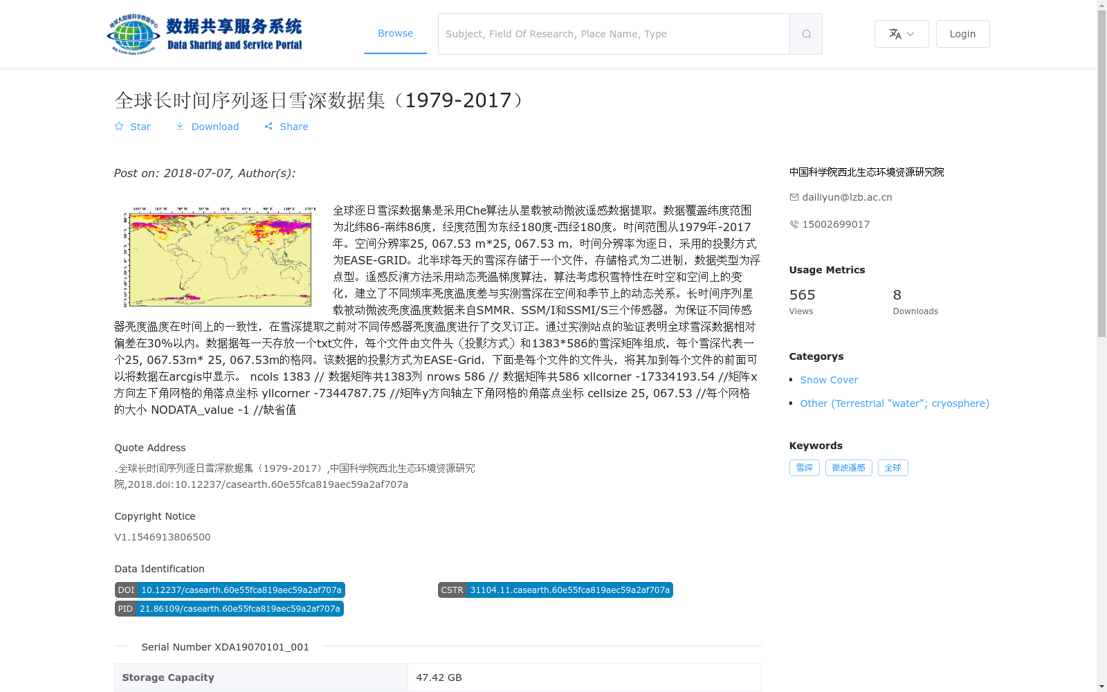
全球逐日雪深数据集是采用Che算法从星载被动微波遥感数据提取。数据覆盖纬度范围为北纬86-南纬86度,经度范围为东经180度-西经180度。时间范围从1979年-2017年。空间分辨率25, 067.53 m*25, 067.53 m,时间分辨率为逐日,采用的投影方式为EASE-GRID。北半球每天的雪深存储于一个文件,存储格式为二进制,数据类型为浮点型。遥感反演方法采用动态亮温梯度算法,算法考虑积雪特性在时空和空间上的变化,建立了不同频率亮度温度差与实测雪深在空间和季节上的动态关系。长时间序列星载被动微波亮度温度数据来自SMMR、SSM/I和SSMI/S三个传感器。为保证不同传感器亮度温度在时间上的一致性,在雪深提取之前对不同传感器亮度温度进行了交叉订正。通过实测站点的验证表明全球雪深数据相对偏差在30%以内。数据据每一天存放一个txt文件,每个文件由文件头(投影方式)和1383*586的雪深矩阵组成,每个雪深代表一个25, 067.53m* 25, 067.53m的格网。该数据的投影方式为EASE-Grid,下面是每个文件的文件头,将其加到每个文件的前面可以将数据在arcgis中显示。
ncols 1383 // 数据矩阵共1383列
nrows 586 // 数据矩阵共586
xllcorner -17334193.54 //矩阵x方向左下角网格的角落点坐标
yllcorner -7344787.75 //矩阵y方向轴左下角网格的角落点坐标
cellsize 25, 067.53 //每个网格的大小
NODATA_value -1 //缺省值
The Global Daily Snow Depth Dataset is extracted from satellite-borne passive microwave remote sensing data using the Che Algorithm. The dataset covers latitudes ranging from 86°N to 86°S, and longitudes ranging from 180°E to 180°W, with a temporal span from 1979 to 2017. The spatial resolution is 25067.53 m × 25067.53 m, with a daily temporal resolution, and the adopted projection is EASE-GRID. Daily snow depth data for the Northern Hemisphere is stored in a single binary file with floating-point data type.
The remote sensing inversion method adopts the dynamic brightness temperature gradient algorithm, which accounts for the spatiotemporal variations of snow cover properties, and establishes a dynamic spatiotemporal and seasonal relationship between brightness temperature differences at different frequencies and in-situ measured snow depth. The long-time series satellite-borne passive microwave brightness temperature data are sourced from three sensors: SMMR, SSM/I, and SSMI/S. To ensure temporal consistency of brightness temperature data across different sensors, cross-calibration was performed on the brightness temperature data from each sensor prior to snow depth extraction.
Validation using in-situ station measurements shows that the relative bias of the global snow depth dataset is within 30%. Each day's data is stored in a text file, which consists of a file header (projection information) and a snow depth matrix of size 1383 × 586. Each element in the matrix represents the snow depth of a grid cell with a size of 25067.53 m × 25067.53 m. The projection of this dataset is EASE-Grid. The following is the file header, which can be prepended to each data file to enable visualization of the data in ArcGIS:
ncols 1383 // Total number of columns in the data matrix
nrows 586 // Total number of rows in the data matrix
xllcorner -17334193.54 // Coordinates of the lower-left grid corner in the x-direction
yllcorner -7344787.75 // Coordinates of the lower-left grid corner in the y-direction
cellsize 25067.53 // Size of each individual grid cell
NODATA_value -1 // Default no-data value
提供机构:
中国科学院西北生态环境资源研究院
搜集汇总
数据集介绍
背景与挑战
背景概述
该数据集是一个全球范围的长时间序列逐日雪深数据集,覆盖1979年至2017年,采用星载被动微波遥感数据通过动态亮温梯度算法反演生成,空间分辨率约为25公里,投影为EASE-GRID。数据经过传感器交叉订正和实测站点验证,相对偏差在30%以内,以二进制和asc格式存储,包含14334个文件,总容量47.42 GB,适用于全球雪深变化研究。
以上内容由遇见数据集搜集并总结生成


