无人机AI智能识别机扫车数据
收藏浙江省数据知识产权登记平台2025-10-10 更新2025-10-11 收录
下载链接:
https://www.zjip.org.cn/home/announce/trends/847702
下载链接
链接失效反馈官方服务:
资源简介:
针对城市道路清洁作业,无人机凭借 70 至 100 米的中低空优势,结合高分辨率传感器与 AI 算法,能快速识别作业中的环卫车辆。给环卫企业智能化管理各种环卫车辆提供有力的数据支撑。可广泛应用于:
1、作业车辆轨迹监督
通过搭载的 AI 图像识别模块,无人机可快速区分洒水车、压缩车、三轮清运车、快保车、厨余垃圾清运车等各类环卫作业车辆,并实时比对其预设作业路线与实际轨迹,自动标记并推送至指挥中心,结合 GPS 位置数据生成辅助考核管理。
2、车辆故障状况判别
当环卫车辆(如路面养护车、新能源机扫车、压缩车等)发生故障,自动定位并向指挥中心发送精确坐标,联系维修人员赶赴现场尽快修理。
3、违规车辆监管
对作业时段外运行、未按规划路线行驶、违规停靠等行为(常见于洒水车、机扫车、压缩车等),无人机即时上传车辆编号与位置至指挥中心,自动生成整改工单。
4、作业时长统计
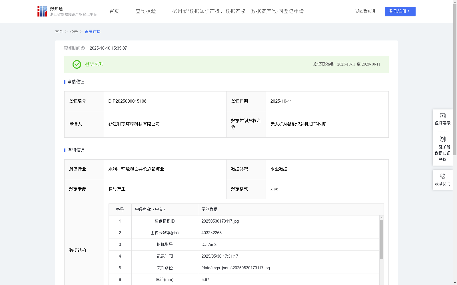
系统可有效统计各类车辆(如雾炮车、厨余垃圾清运车等)的作业时长、覆盖面积,判定有效作业时段,排除空驶、停靠等非作业状态。生成量化考核报表,分析不同车型在各路段的作业效率。1、数据来源: 数据来源于本企业无人机智能巡查系统。2、高分辨率图像通过无人机采集,记录丰富元信息,包括图像标识ID、图像分辨率(pix)、相机型号、记录时间、文件路径、焦距(mm)、经纬度、海拔(m)、边界框组、置信度阈值、置信度、一级标签和二级标签,经人工清洗剔除噪声,确保数据可靠性。数据采用两级标签:初始细化目标类型标为二级标签(机扫车),记录边界框及属性,后映射为一级标签(车辆)。3、算法基于YOLOv8m,集成P2层通过图像分片优化小目标检测,结合迁移学习加载预训练权重。预训练权重使用在COCO数据集上预训练的模型参数yolov8m.pt,适用于通用目标检测任务。微调时,保留骨干网络低层次特征提取层权重,冻结部分层以防过拟合,调整检测头参数,设置学习率0.01、批量大小8。4、在推理阶段,设定置信度阈值为0.45,目标置信度由模型输出,反映目标检测的可信水平。仅保留高于此阈值的检测结果作为目标,即置信度输出大于等于0.45的检测框视为正样本(机扫车),小于0.45的检测框视为背景负样本。
For urban road cleaning operations, drones, leveraging their medium-to-low altitude advantage (70 to 100 meters) combined with high-resolution sensors and AI algorithms, can rapidly identify sanitation vehicles in operation. This provides robust data support for sanitation enterprises to intelligently manage various types of sanitation vehicles, and can be widely applied in the following scenarios:
1. Work vehicle trajectory supervision: Equipped with an AI image recognition module, drones can quickly distinguish various types of sanitation operation vehicles including sprinkler trucks, compression trucks, three-wheeled waste collection trucks, quick maintenance vehicles, and kitchen waste collection trucks. It can compare their preset operation routes with actual trajectories in real time, automatically mark and push the information to the command center, and generate auxiliary assessment management reports combined with GPS location data.
2. Vehicle fault status judgment: When sanitation vehicles (such as road maintenance trucks, new energy street sweepers, compression trucks, etc.) malfunction, drones can automatically locate them and send precise coordinates to the command center, notifying maintenance personnel to rush to the site for timely repairs.
3. Non-compliant vehicle supervision: For behaviors such as operating outside the scheduled work hours, driving without following the planned route, and unauthorized parking (common in sprinkler trucks, street sweepers, compression trucks, etc.), drones will immediately upload the vehicle number and location to the command center, and automatically generate rectification work orders.
4. Operation duration statistics: The system can effectively count the operation duration and covered area of various vehicles (such as fog cannon trucks, kitchen waste collection trucks, etc.), determine valid operation periods, exclude non-operation states such as empty driving and parking, generate quantitative assessment reports, and analyze the operation efficiency of different vehicle types on each road section.
1. Data source: The data is collected from the enterprise's UAV intelligent inspection system.
2. High-resolution images are collected by drones, with rich metadata recorded, including image ID, image resolution (pix), camera model, recording time, file path, focal length (mm), longitude and latitude, altitude (m), bounding box group, confidence threshold, confidence score, primary label and secondary label. The data is manually cleaned to remove noise to ensure data reliability. A two-level labeling system is adopted: the initially refined target type is marked as the secondary label (e.g., street sweeper), with bounding boxes and attributes recorded, and then mapped to the primary label (e.g., vehicle).
3. The algorithm is based on YOLOv8m, integrating the P2 layer to optimize small object detection via image tiling, and using transfer learning to load pretrained weights. The pretrained weights are the model parameters yolov8m.pt pretrained on the COCO dataset, which is suitable for general object detection tasks. During fine-tuning, the weights of the low-level feature extraction layers of the backbone network are retained, some layers are frozen to prevent overfitting, and the detection head parameters are adjusted, with the learning rate set to 0.01 and batch size set to 8.
4. During the inference stage, the confidence threshold is set to 0.45. The target confidence is output by the model, reflecting the credibility level of object detection. Only detection results with a confidence score greater than or equal to 0.45 are retained as positive samples (e.g., street sweepers), while detection boxes with a confidence score less than 0.45 are regarded as background negative samples.
提供机构:
浙江利珉环境科技有限公司
创建时间:
2025-08-13
搜集汇总
数据集介绍
背景与挑战
背景概述
该数据集是浙江利珉环境科技有限公司登记的无人机AI智能识别机扫车数据,包含502条每日更新的记录,数据格式为xlsx,涵盖图像标识、分辨率、经纬度、置信度和车辆标签等元信息。其特点在于利用YOLOv8m算法和迁移学习进行高精度目标检测,置信度阈值为0.45,应用于城市道路清洁作业的车辆轨迹监督、故障判别和违规监管,为环卫企业提供智能化管理支持。
以上内容由遇见数据集搜集并总结生成


