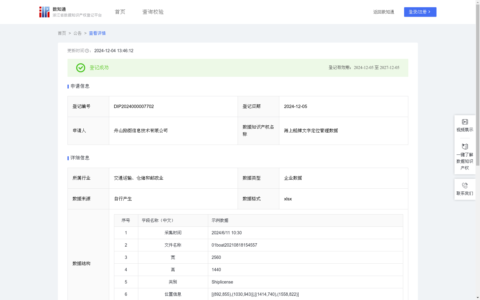
海上船牌文字定位管理数据
收藏浙江省数据知识产权登记平台2024-12-04 更新2024-12-11 收录
下载链接:
https://www.zjip.org.cn/home/announce/trends/95614
下载链接
链接失效反馈官方服务:
资源简介:
海上船牌文字定位管理数据的应用场景主要集中在海事管理、港口监控、非法活动打击以及海上救援等领域。在海事管理方面,利用该技术能够实时定位船只的船牌位置,帮助海事部门判断船只是否安装船牌,海事部门可以获取并定位船只上的船牌位置。这不仅帮助确认船只是否按照规定安装了船牌,还能验证船牌信息的真实性,防止伪造或篡改,确保船只身份的准确性和可追溯性。在海上救援行动中,通过快速定位遇险船只的船牌位置,救援队伍能够迅速确定事故地点,缩短响应时间,提高救援成功率。1、数据来源:通过安装在海事执法船只、岸边监控站或无人机上的高清摄像设备捕捉海上船只图像。2、数据预处理:对捕获的图像进行去噪处理;增强图像对比度;调整亮度和对比度以提高图像质量。3、数据处理:提取安全装置特征,如形状、颜色、纹理等;使用YOLO算法进行目标检测,识别和定位安全装置。安全装置的位置信息被存储在"位置信息"字段中,字段包含一个二维坐标数组,其中每个元素是一个 (x, y) 坐标对,表示边界框的对角点坐标。这些坐标点按特定顺序排列,当依次连接时,形成一个矩形,精确地描绘出船牌文字的位置和大小。基于提取的特征,系统为每个检测到的船牌分配相应的标签,如"Shiplicense"表示船牌,并计算检测到的船牌数量。数据应用:通过海上船牌文字定位管理数据,海事部门可以更好地掌握海上船只分布情况,做出有效的海上管理决策,提高海事管理效率和海上安全水平。这些数据可用于实时监控船只身份信息、优化海上交通管理、协助海上执法行动,从而降低海上安全风险,确保海上活动的合法性和安全性。
The application scenarios of the ship license plate text positioning and management dataset mainly cover maritime management, port monitoring, crackdown on illegal activities, and maritime rescue.
In terms of maritime management, this technology can locate the position of ship license plates in real time, helping maritime authorities determine whether ships are equipped with such license plates. Maritime departments can acquire and pinpoint the location of license plates on ships. This not only helps verify whether ships have installed license plates in accordance with regulations, but also confirms the authenticity of license plate information, preventing forgery or tampering, and ensuring the accuracy and traceability of ship identities.
During maritime rescue operations, by quickly locating the license plate position of distressed vessels, rescue teams can rapidly determine the accident location, shorten response time, and improve the success rate of rescue efforts.
1. Data Source: High-definition camera equipment installed on maritime law enforcement vessels, shore-based monitoring stations or unmanned aerial vehicles (UAVs) is used to capture images of ships at sea.
2. Data Preprocessing: Denoise the captured images; enhance image contrast; adjust brightness and contrast to improve overall image quality.
3. Data Processing: Extract features of safety devices including shape, color, texture, etc.; employ the YOLO algorithm for object detection to identify and locate these safety devices. The position information of the safety devices is stored in the "location information" field, which contains a 2D coordinate array. Each element is a (x, y) coordinate pair representing the diagonal corner coordinates of the bounding box. These coordinate points are arranged in a specific order, and when connected sequentially, they form a rectangle that accurately depicts the position and size of the ship license plate text. Based on the extracted features, the system assigns corresponding labels to each detected license plate (e.g., "Shiplicense" denotes a ship license plate) and calculates the number of detected license plates.
Data Application: With the ship license plate text positioning and management dataset, maritime authorities can better grasp the distribution of ships at sea, make effective maritime management decisions, and enhance maritime management efficiency and maritime safety levels. This data can be used for real-time monitoring of ship identity information, optimizing maritime traffic management, and assisting maritime law enforcement operations, thereby reducing maritime safety risks and ensuring the legality and safety of maritime activities.
提供机构:
舟山励图信息技术有限公司
创建时间:
2024-09-03
搜集汇总
数据集介绍
特点
海上船牌文字定位管理数据是一个由舟山励图信息技术有限公司提供的企业数据集,包含590条记录,主要用于海事管理、港口监控和海上救援等场景。数据集通过YOLO算法进行船牌定位,数据结构包括采集时间、位置信息和船牌数量等关键字段。
以上内容由遇见数据集搜集并总结生成


