QTP-HRAD
收藏DataCite Commons2025-04-27 更新2025-05-18 收录
下载链接:
https://www.scidb.cn/detail?dataSetId=f0860df1bd8e4fee842baa70fe6d9b94
下载链接
链接失效反馈官方服务:
资源简介:
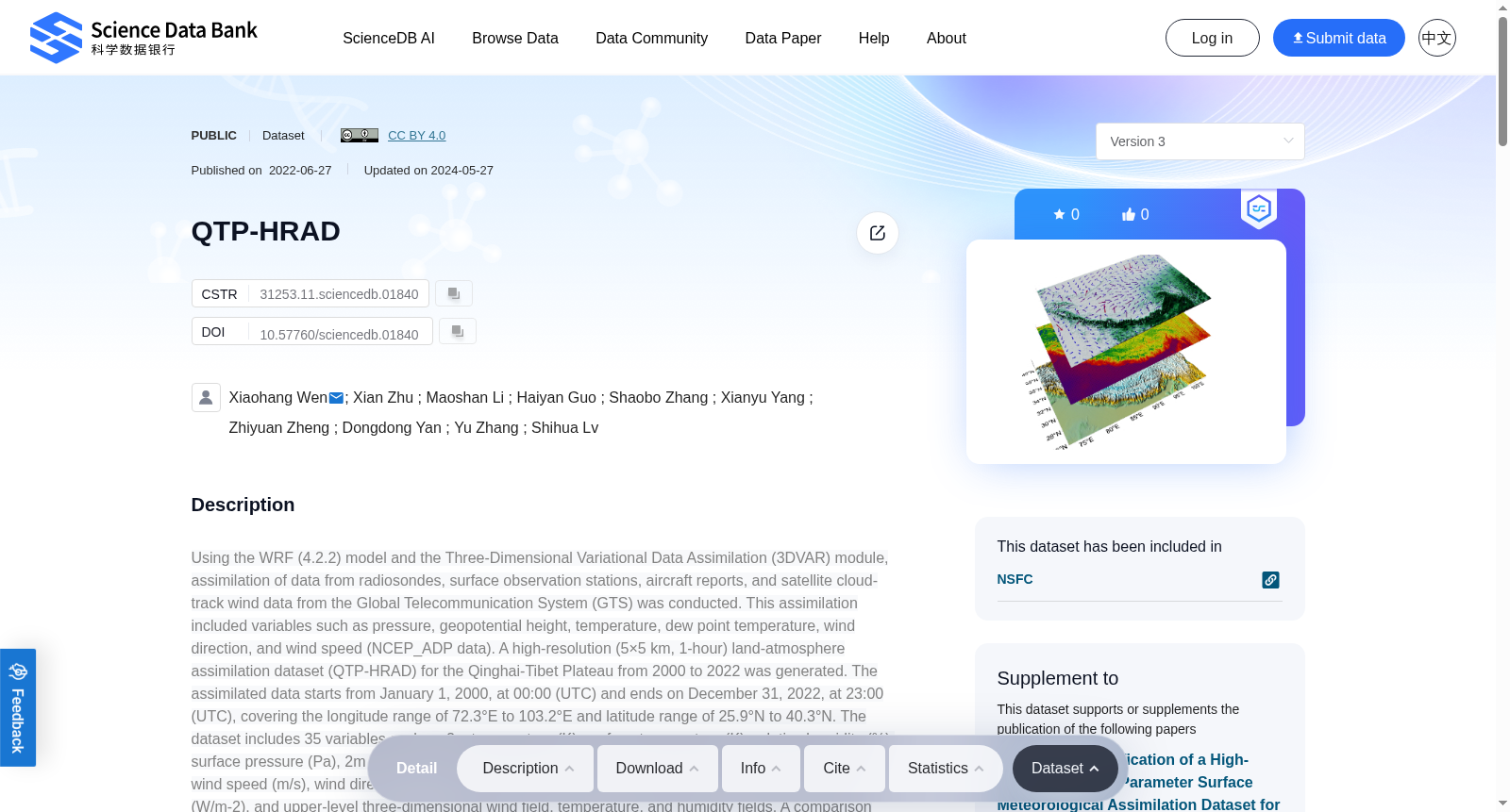
Using the WRF (4.2.2) model and the Three-Dimensional Variational Data Assimilation (3DVAR) module, assimilation of data from radiosondes, surface observation stations, aircraft reports, and satellite cloud-track wind data from the Global Telecommunication System (GTS) was conducted. This assimilation included variables such as pressure, geopotential height, temperature, dew point temperature, wind direction, and wind speed (NCEP_ADP data). A high-resolution (5×5 km, 1-hour) land-atmosphere assimilation dataset (QTP-HRAD) for the Qinghai-Tibet Plateau from 2000 to 2022 was generated. The assimilated data starts from January 1, 2000, at 00:00 (UTC) and ends on December 31, 2022, at 23:00 (UTC), covering the longitude range of 72.3°E to 103.2°E and latitude range of 25.9°N to 40.3°N. The dataset includes 35 variables such as 2m temperature (K), surface temperature (K), relative humidity (%), surface pressure (Pa), 2m water vapor mixing ratio (kg/kg), 10m U and V wind components (m/s), 10m wind speed (m/s), wind direction (°), precipitation (mm), dew point temperature (℃), surface energy flux (W/m-2), and upper-level three-dimensional wind field, temperature, and humidity fields. A comparison was made between observational data from 10 stations around the plateau and QTP-HRAD for analysis. The daily averages from QTP-HRAD were found to be generally consistent with observational values, showing consistent annual trends and reflecting the interannual characteristics of meteorological elements such as temperature, humidity, precipitation, evaporation, pressure, and wind speed. However, there were significant statistical errors at stations with complex terrain conditions. Comparison of the regional distributions between QTP-HRAD and ERA-5 data revealed that the 5×5 km spatial resolution provides more accurate regional distributions of meteorological elements compared to the 0.25×0.25 ERA-5 data, highlighting differences in temperature, humidity, wind speed, and precipitation distributions due to variations in terrain height. This assimilation dataset can be used for studying land-atmosphere interactions, energy-water cycles, and extreme weather processes in the Qinghai-Tibet Plateau region, providing fundamental data for comprehensive evaluations of plateau ecological environments and extreme weather climates.For long simulations, the model provides an alternative to read-in the time-varying data and to update these fields. In order to use this option, one must have access to time-varying Sea Surface Temperature (SST) and sea ice fields. Twelve monthly values of vegetation fraction and albedo are available from the geogrid program. As this data is generated by WRF mode using the warm start method, the precipitation value at time 00:00, 06:00, 12:00, and 18:00 is 0. So the precipitation value is the accumulated precipitation value every 6 hours.
提供机构:
Science Data Bank
创建时间:
2022-06-27
搜集汇总
数据集介绍
背景与挑战
背景概述
QTP-HRAD是一个高分辨率(5×5公里,1小时)的陆气同化数据集,覆盖青藏高原2000年至2022年,包含35个气象变量如温度、湿度和风速,用于研究该区域的陆气相互作用和极端天气过程。数据集基于WRF模型和数据同化技术生成,数据量达18.10 TB,提供更精确的空间分布信息,支持高原生态环境和气候评估。
以上内容由遇见数据集搜集并总结生成


