青藏高原GNSS应变率场数据(1999-2024)
收藏国家青藏高原科学数据中心2025-01-07 更新2025-01-25 收录
下载链接:
https://data.tpdc.ac.cn/zh-hans/data/e76a4668-db28-4c91-8ff7-b75ffe6bba8d
下载链接
链接失效反馈官方服务:
资源简介:
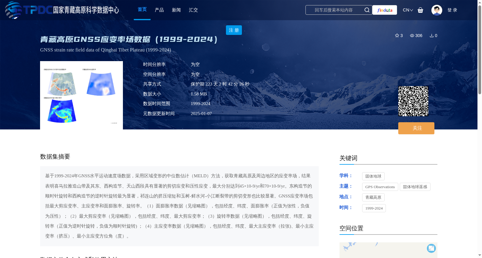
基于1999-2024年GNSS水平运动速度场数据,采用区域变形的中位数估计(MELD)方法,获取青藏高原及周边地区的应变率场,结果表明喜马拉雅造山带及其东、西构造节、天山西段具有显著的剪切应变和压性应变,最大分别达到45×10-9/yr和70×10-9/yr。东构造节的顺时针旋转和西构造节的逆时针旋转最为显著,祁连山的挤压缩短和玉树-鲜水河-小江断裂带的剪切变形也比较显著。GNSS应变率场包括最大剪应变率、主应变率和面膨胀率、旋转率。(1)面膨胀率数据(见缩略图),包括经度、纬度、面膨胀率(正值为张性,负值为压性);(2)最大剪应变率(见缩略图),包括经度、纬度、最大剪应变率;(3)旋转率数据(见缩略图),包括经度、纬度、旋转率(正值为逆时针旋转,负值为顺时针旋转) ;(4)主应变率数据(见缩略图),包括经度、纬度、最大主应变率(拉张)、最小主应变率(挤压)、最小主应变方位角(度)。
Based on GNSS horizontal velocity field data from 1999 to 2024, the strain rate field of the Tibetan Plateau and its surrounding regions was derived using the Median Estimator for Local Deformation (MELD) method. The results show that the Himalayan orogenic belt, its eastern and western syntaxes, and the western segment of the Tianshan Mountains are characterized by significant shear and compressional strains, with maximum values reaching 45×10^-9/yr and 70×10^-9/yr respectively. The clockwise rotation at the eastern syntax and counterclockwise rotation at the western syntax are the most prominent; notable crustal shortening in the Qilian Mountains and shear deformation along the Yushu-Xianshuihe-Xiaojiang fault zone are also significant. The GNSS-derived strain rate field includes maximum shear strain rate, principal strain rate, areal dilation rate, and rotation rate. The detailed datasets are listed below: (1) Areal dilation rate data (see thumbnail): includes longitude, latitude, and areal dilation rate (positive values indicate extensional strain, negative values indicate compressional strain); (2) Maximum shear strain rate data (see thumbnail): includes longitude, latitude, and maximum shear strain rate; (3) Rotation rate data (see thumbnail): includes longitude, latitude, and rotation rate (positive values indicate counterclockwise rotation, negative values indicate clockwise rotation); (4) Principal strain rate data (see thumbnail): includes longitude, latitude, maximum principal strain rate (extensional), minimum principal strain rate (compressional), and azimuth of the minimum principal strain (in degrees).
提供机构:
郝 明
创建时间:
2025-01-03
搜集汇总
数据集介绍
背景与挑战
背景概述
该数据集基于1999-2024年GNSS水平运动速度场数据,采用区域变形的中位数估计(MELD)方法,生成了青藏高原及周边地区的应变率场,包括面膨胀率、最大剪应变率、旋转率和主应变率四类关键指标。数据覆盖空间范围东经64.4°-110.1°、北纬20.1°-46.5°,揭示了喜马拉雅造山带等区域的显著剪切和压性应变特征,最大应变率分别达到45×10⁻⁹/yr和70×10⁻⁹/yr,适用于固体地球科学研究。
以上内容由遇见数据集搜集并总结生成


