1976年青藏高原Landsat MSS/TM冰川格网数据产品
收藏地球大数据科学工程2024-03-04 收录
下载链接:
https://data.casearth.cn/sdo/detail/5c19a5690600cf2a3c557ba6
下载链接
链接失效反馈官方服务:
资源简介:
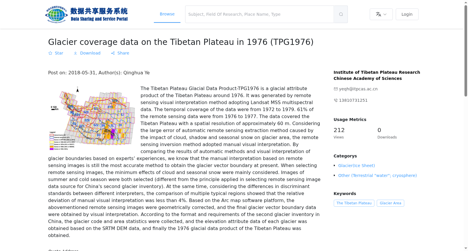
“青藏高原冰川格网数据产品-TPG1976”为1976年左右的青藏高原冰川属性产品,采用Landsat MSS多光谱数据基于遥感目视解译方法制作,数据覆盖时间从1972年到1979年,其中61%的遥感数据源来自于1976/1977年。覆盖范围为青藏高原,遥感数据源的空间分辨率约为60m。遥感反演方法采用人工目视解译,主要考虑了基于自动化遥感提取方法获得的冰川面积易受云、阴影和季节性积雪的影响,进而利用遥感自动化提取方法会导致较大的误差。通过对比自动化方法和结合专家经验目视解译冰川边界的结果,可知目前基于遥感影像的人工目视解译仍是获得冰川矢量边界的最准确的方法。选取遥感影像时主要考虑最小云影响和最小季节性积雪影响,选取的影像时间即包括夏季也包括冷季(与中国第二次冰川编目选择遥感影像数据源的原则略有不同)。同时考虑到人为目视解译时不同解译人员之间的判别标准差异,通过多个典型区域对比表明人工目视解译的相对偏差小于4%。基于Arc map软件平台对上述遥感影像进行几何校正后通过目视解译获得最终的冰川矢量边界数据,按照中国第二次冰川编目的格式和要求,对上述矢量数据进行冰川编号和面积统计,并基于SRTM DEM数据获得各冰川的高程属性数据等,最终得到1976年的青藏高原冰川格网数据产品。
The Qinghai-Tibet Plateau Glacier Grid Data Product (TPG1976) is a glacier attribute dataset for the Qinghai-Tibet Plateau dating to around 1976. It was generated using Landsat MSS multispectral data via remote sensing visual interpretation. The data covers the period from 1972 to 1979, with 61% of the remote sensing sources originating from 1976 and 1977. The dataset spans the entire Qinghai-Tibet Plateau, and the spatial resolution of the utilized remote sensing imagery is approximately 60 meters.
Manual visual interpretation was selected as the remote sensing inversion method, primarily because automated remote sensing extraction methods for glacier area are highly susceptible to interference from clouds, shadows and seasonal snow cover, thereby introducing significant errors. Comparative analyses between automated extraction results and glacier boundaries interpreted visually with expert prior knowledge demonstrate that manual visual interpretation of remote sensing imagery remains the most accurate approach for acquiring glacier vector boundaries to date.
When selecting remote sensing images, priority was given to scenes with minimal cloud and seasonal snow cover impacts; the selected imagery spans both summer and cold seasons, which slightly differs from the principle for selecting remote sensing data sources for the Second Chinese Glacier Inventory. Considering the potential discrepancies in interpretation criteria across different analysts during manual visual interpretation, multi-region comparative assessments reveal that the relative deviation of manual visual interpretation is less than 4%.
The final glacier vector boundary data was obtained through visual interpretation following geometric correction of the remote sensing images using the ArcMap software platform. In accordance with the format and specifications of the Second Chinese Glacier Inventory, the vector data was assigned unique glacier identifiers and underwent area statistics. Elevation attribute data for each glacier was derived based on SRTM DEM data. Ultimately, the 1976 Qinghai-Tibet Plateau Glacier Grid Data Product was completed.
提供机构:
中科院青藏高原研究所
搜集汇总
数据集介绍
背景与挑战
背景概述
该数据集是1976年前后青藏高原冰川属性产品,基于Landsat MSS多光谱数据通过人工视觉解译方法生成,时间覆盖1972-1979年(主要数据集中在1976-1977年),空间分辨率约60米。数据处理中特别考虑了云和季节性雪的影响,确保冰川边界解译的准确性,相对偏差小于4%。
以上内容由遇见数据集搜集并总结生成


