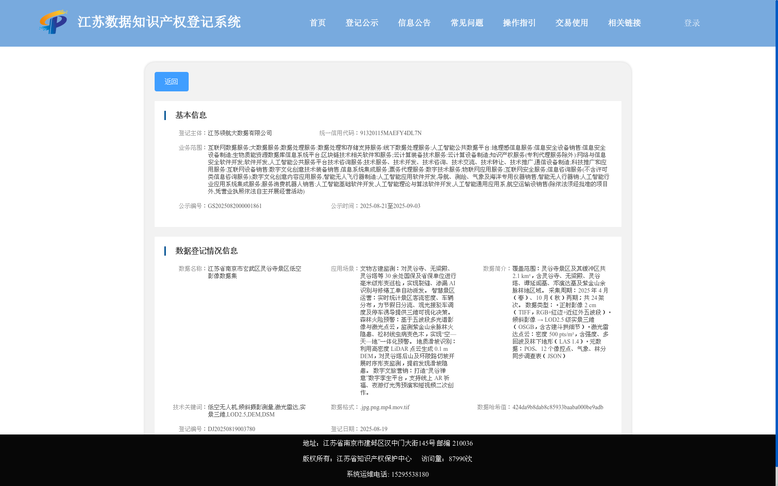
江苏省南京市玄武区灵谷寺景区低空影像数据集
收藏江苏数据知识产权登记系统2025-08-20 更新2025-09-06 收录
下载链接:
https://dataip.jsipp.cn/#/changeDetialCertical?pType=登记&cType=登记&id=c112d673233178afb89a927a96f4e68d
下载链接
链接失效反馈官方服务:
资源简介:
覆盖范围:灵谷寺景区及其缓冲区共 2.1 km²,含灵谷寺、无梁殿、灵谷塔、谭延闿墓、邓演达墓及紫金山余脉林地区域。
采集周期:2025 年 4 月(春)、10 月(秋)两期;共 24 架次。
数据类型:
• 正射影像 2 cm(TIFF,RGB+红边+近红外五波段)
• 倾斜影像 → LOD2.5 级实景三维(OSGB,含古建斗拱细节)
• 激光雷达点云:密度 500 pts/m²,含强度、多回波及林下地形(LAS 1.4)
• 元数据:POS、12 个像控点、气象、林分同步调查表(JSON)
Coverage: The Linggu Temple Scenic Area and its buffer zone, with a total area of 2.1 km², encompasses Linggu Temple, Wuliang Hall, Linggu Pagoda, the Tomb of Tan Yankai, the Tomb of Deng Yanda, and the forested area of the Zijin Mountain offshoots.
Collection Period: Two survey campaigns were conducted in April (spring) and October (autumn) 2025, with a total of 24 sorties.
Data Types:
• Orthophotos: 2 cm ground sampling distance (GSD), in TIFF format, with 5 bands including RGB, red edge, and near-infrared.
• Oblique Imagery: LOD2.5 level real-scene 3D models in OSGB format, featuring detailed dougong (traditional Chinese timber bracket sets) of ancient architectures.
• LiDAR Point Clouds: Density of 500 points per square meter, with intensity, multi-return data and understory terrain information, in LAS 1.4 format.
• Metadata: POS data, 12 ground control points (GCPs), meteorological records, and synchronized stand inventory survey forms, stored in JSON format.
提供机构:
江苏领航大数据有限公司
搜集汇总
数据集介绍
背景与挑战
背景概述
该数据集包含江苏省南京市玄武区灵谷寺景区的低空影像数据,主要用于记录和分析景区的地理特征与景观变化。其特点在于采用低空拍摄技术,提供高分辨率影像,适用于旅游规划、环境监测和文化遗产保护等领域。
以上内容由遇见数据集搜集并总结生成


