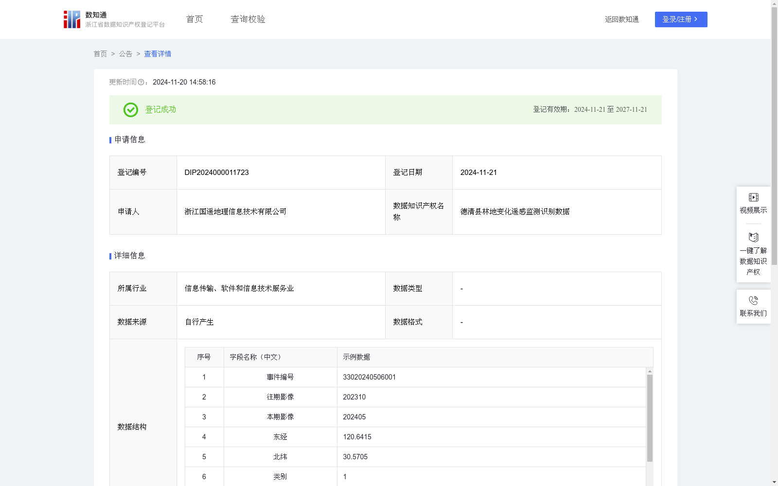
德清县林地变化遥感监测识别数据
收藏浙江省数据知识产权登记平台2024-11-20 更新2024-11-21 收录
下载链接:
https://www.zjip.org.cn/home/announce/trends/86978
下载链接
链接失效反馈官方服务:
资源简介:
用于实现对林地变化监测中问题点位的高效精准识别,主要为林地减少区域的发现、坐标位置确认等。便于林地监管人员及时发现问题,全面掌握林地情况。解决了林地监管中,因林地范围太大,野外环境危险导致的巡查与监管困难。系统由遥感影像自动识别并提取变化区域,判定变化区域为林地后,自动建立林地变化智能工单。系统中能够查看林地变化区域的影像、坐标等信息。基于无人机航拍采集德清县域遥感影像数据,通过影像对比与YOLO算法识别出林地变化区域。首先将两期影像如示例数据所示2023年10月与2024年5月进行对比得到所有发生变化的区域,在此基础上建立遥感影像林地识别深度学习网络。将单元神经网络应用于完整的遥感影像,将图像分割成规则的单元格,每个单元神经网络负责预测K个单元格。预测每个区域的概率,所有单元格上具有最大概率的类被选择并分配给特定的网格单元,生成由预测概率加权的边界框。在预测类概率后,进行NMS运算,算法识别下一个最高类别概率的边界框,并进行相同的运算过程,直到剩下所有不同的边界框。算法输出所需的向量,并对各类地物进行分类,接着筛选出类别为林地的区域。
抽取样本进行结果验证,得到识别准确度,越接近1说明该地块识别越准确,小于0.6视为识别错误,通过判断结果正确或错误来纳入或排除数据。对识别正确的地块计算区域中心坐标(x,y)使用CGCS2000坐标系,影像默认为东经、北纬。最后将影像中的特征区域与坐标等信息自动上传至德清林地变化遥感监测平台,最终获得德清林地变化遥感监测识别数据。
This dataset is designed for efficient and accurate identification of problematic points in forestry change monitoring, mainly focusing on detecting areas with reduced forest cover and confirming their coordinate positions. It facilitates forestry supervisors to timely detect issues and fully grasp the overall status of forestlands, solving the difficulties in forestry supervision caused by the large scale of forestlands and the dangerous field environment that previously hindered on-site patrols and supervision work.
The system automatically identifies and extracts changed areas from remote sensing images, and automatically generates intelligent work orders for forestry changes after confirming that the changed areas are forestlands. Relevant information such as images and coordinates of forestry change areas can be viewed within the system.
Based on remote sensing image data of Deqing County collected via UAV aerial photography, forestry change areas are identified through image comparison and the YOLO algorithm. First, compare two phases of images (October 2023 and May 2024 as shown in the sample data) to obtain all changed areas, and then build a deep learning network for forestland recognition from remote sensing images on this basis.
The unit neural network is applied to the complete remote sensing image, which divides the image into regular grid cells, and each unit neural network is responsible for predicting K cells. Predict the probability of each region; the class with the highest probability across all cells is selected and assigned to a specific grid cell, generating bounding boxes weighted by the prediction probabilities. After predicting the class probabilities, Non-Maximum Suppression (NMS) operation is performed: the algorithm identifies the bounding box with the next highest class probability and repeats the same process until all distinct bounding boxes remain. The algorithm outputs the required vectors, classifies various ground objects, and then filters out the regions classified as forestlands.
Sample extraction is conducted for result verification to obtain the recognition accuracy. The closer the accuracy value is to 1, the more accurate the plot recognition is; a value less than 0.6 is regarded as a recognition error. Data is included or excluded based on whether the recognition result is correct or not. For the correctly recognized plots, calculate the regional central coordinates (x, y) using the CGCS2000 coordinate system, where the images default to east longitude and north latitude. Finally, automatically upload information such as the feature regions and coordinates in the images to the Deqing Forestry Change Remote Sensing Monitoring Platform, and finally obtain the Deqing forestry change remote sensing monitoring and recognition dataset.
提供机构:
浙江国遥地理信息技术有限公司
创建时间:
2024-10-17
搜集汇总
数据集介绍
特点
该数据集包含521条德清县林地变化遥感监测识别数据,每半年更新一次,主要用于林地变化监测中问题点位的高效精准识别。数据通过无人机航拍和YOLO算法进行采集和处理,能够识别林地变化区域并确认坐标位置。
以上内容由遇见数据集搜集并总结生成


