一带一路沿线20国土壤可蚀性因子数据集
收藏国家地球系统科学数据中心2023-07-11 更新2024-03-04 收录
下载链接:
https://www.geodata.cn/data/datadetails.html?dataguid=19281248246199&docId=4640
下载链接
链接失效反馈官方服务:
资源简介:
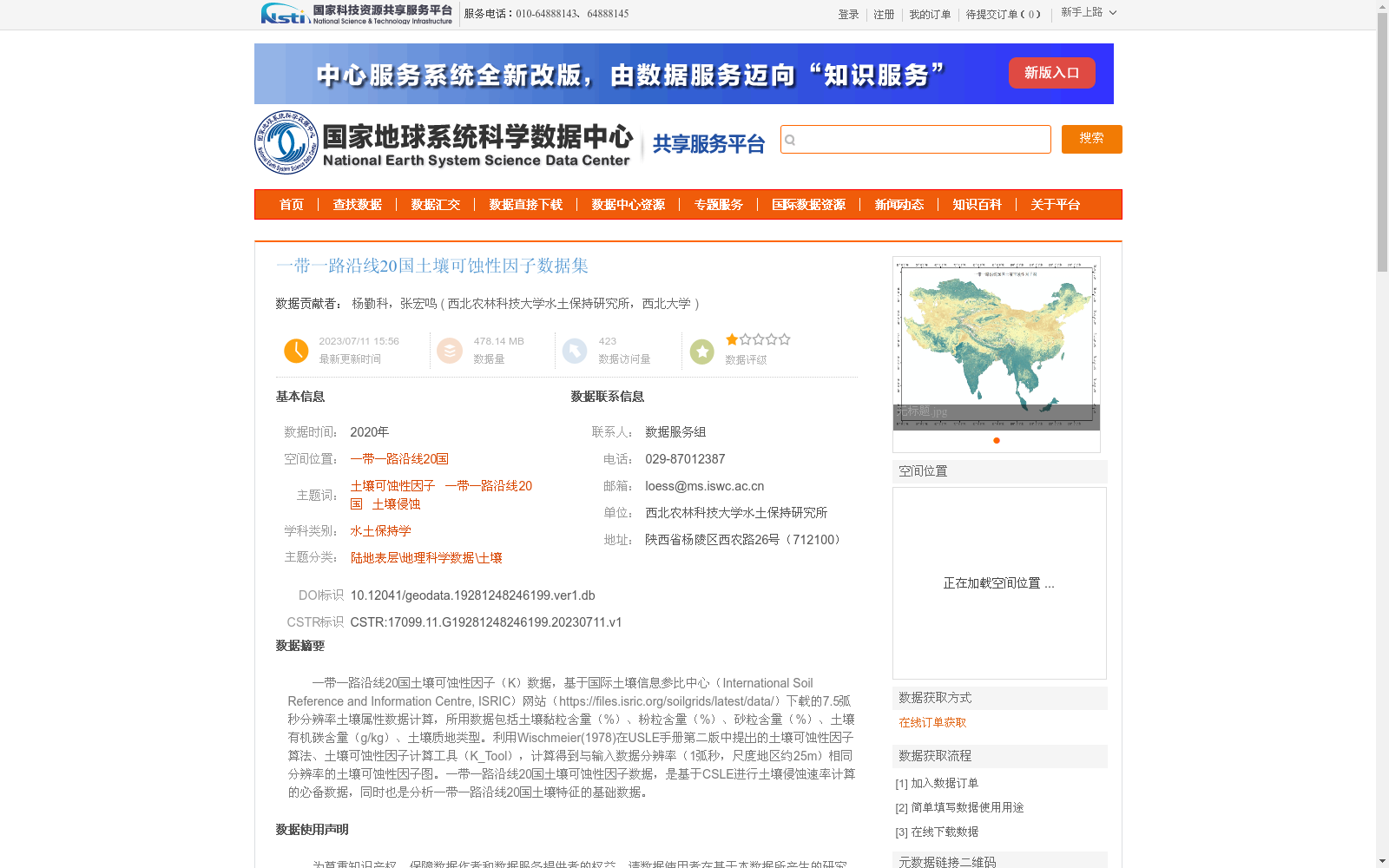
一带一路沿线20国土壤可蚀性因子(K)数据,基于国际土壤信息参比中心(International Soil Reference and Information Centre, ISRIC)网站(https://files.isric.org/soilgrids/latest/data/)下载的7.5弧秒分辨率土壤属性数据计算,所用数据包括土壤黏粒含量(%)、粉粒含量(%)、砂粒含量(%)、土壤有机碳含量(g/kg)、土壤质地类型。利用Wischmeier(1978)在USLE手册第二版中提出的土壤可蚀性因子算法、土壤可蚀性因子计算工具(K_Tool),计算得到与输入数据分辨率(1弧秒,尺度地区约25m)相同分辨率的土壤可蚀性因子图。一带一路沿线20国土壤可蚀性因子数据,是基于CSLE进行土壤侵蚀速率计算的必备数据,同时也是分析一带一路沿线20国土壤特征的基础数据。
Soil Erodibility Factor (K) Dataset for 20 Countries Along the Belt and Road
This dataset is calculated based on 7.5 arc-second resolution soil attribute data downloaded from the International Soil Reference and Information Centre (ISRIC) website (https://files.isric.org/soilgrids/latest/data/). The input datasets include clay content (%), silt content (%), sand content (%), soil organic carbon content (g/kg), and soil texture type. Soil erodibility factor maps matching the resolution of the input data (1 arc-second, approximately 25m per spatial unit) were generated using the soil erodibility factor algorithm proposed by Wischmeier (1978) in the second edition of the Universal Soil Loss Equation (USLE) manual and the Soil Erodibility Factor Calculation Tool (K_Tool). This soil erodibility factor dataset for 20 countries along the Belt and Road is a mandatory dataset for calculating soil erosion rates based on the Chinese Soil Loss Equation (CSLE), and also serves as a foundational dataset for analyzing the soil characteristics of these 20 countries along the Belt and Road.
提供机构:
西北农林科技大学水土保持研究所,西北大学
创建时间:
2023-07-11
搜集汇总
数据集介绍
背景与挑战
背景概述
该数据集包含一带一路沿线20国的土壤可蚀性因子数据,基于高分辨率土壤属性数据计算得出,适用于土壤侵蚀速率计算和土壤特征分析。数据由西北农林科技大学水土保持研究所和西北大学贡献,质量优良可靠。
以上内容由遇见数据集搜集并总结生成


