全球多源融合-校正降水数据集(GMCP,0.1°,逐小时,2000-2024,全球)
收藏国家青藏高原科学数据中心2025-01-10 更新2025-04-19 收录
下载链接:
https://data.tpdc.ac.cn/zh-hans/data/b747a341-461d-4d1b-8209-f79dc964baaf
下载链接
链接失效反馈官方服务:
资源简介:
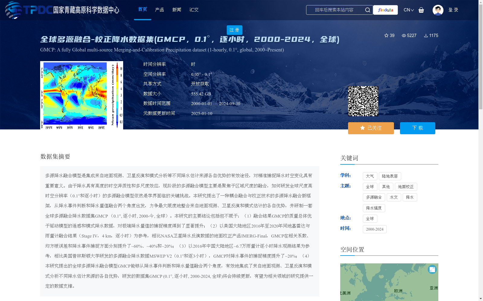
多源降水融合模型是集成来自地面观测、卫星反演和模式分析等不同降水估计来源各自优势的有效途径,对精准捕捉降水时空变化具有重要意义。由于降水具有高度的时空异质性和多尺度效应,现阶段的多源融合模型主要是聚焦于区域尺度的融合,如何研发全球尺度高时空分辨率(0.1°和逐小时)的多源融合模型依然是学界面临的关键挑战。本研究提出了一种耦合融合与校正技术的多源降水融合新框架,从降水事件判断和降水量值融合两个角度出发,力争最大限度地整合来自地面观测、卫星反演和模式估计的各自优势,并研制一套全球多源融合降水数据集GMCP (0.1°, 逐小时, 2000-今, 全球)。本研究的主要结论包括但不限于:(1)融合结果GMCP的质量总体优于驱动模型的遥感和模式降水数据,对极端降水量值的捕捉精度得到了显著提升;(2)以美国大陆地区2016年至2020年间地基雷达与雨量计融合结果(Stage IV,4 km,逐小时)为参考,相比NASA卫星降水反演数据的地面校正产品IMERG-Final,GMCP在相关系数、均方根误差和降水事件捕捉方面分别提升了~60%、~40%和~20%;(3)以2016年中国大陆地区~6.7万雨量计逐小时降水观测结果为参考,相比美国普林斯顿大学研发的多源融合降水数据MSWEP V2(0.1°和逐3小时),GMCP对降水事件的捕捉精度提升了~20%;(4)本研究提出的全球多源降水融合模型GMCP能够从降水事件判断和降水量值融合两个角度,有效地集成了来自地面观测、卫星反演和模式分析不同降水估计来源的各自优势,研发的数据集GMCP (0.1°, 逐小时, 2000-2024, 全球)将会持续更新,有望为相关领域的研究提供一定的数据支撑。
Multi-source precipitation fusion models are effective approaches that integrate the respective advantages of different precipitation estimation sources such as ground observations, satellite retrievals, and model analyses, and are of great significance for accurately capturing the spatiotemporal variations of precipitation. Given that precipitation exhibits high spatiotemporal heterogeneity and multi-scale effects, current multi-source fusion models mainly focus on regional-scale fusion. Developing multi-source fusion models with high spatiotemporal resolution (0.1° and hourly) at the global scale remains a key challenge faced by the academic community. This study proposes a novel multi-source precipitation fusion framework that couples fusion and correction techniques. Starting from two perspectives: precipitation event identification and precipitation amount fusion, it strives to maximize the integration of respective advantages from ground observations, satellite retrievals, and model estimations, and develops a global multi-source merged precipitation dataset GMCP (0.1°, hourly, 2000–present, global coverage). The main conclusions of this study include but are not limited to: (1) The quality of the fusion result GMCP is generally superior to that of the remote sensing and model precipitation data from the driving models, and the accuracy of capturing extreme precipitation amounts has been significantly improved; (2) Taking the ground-based radar and rain gauge fusion result (Stage IV, 4 km, hourly) over the contiguous United States from 2016 to 2020 as the reference, compared with the ground-calibrated satellite precipitation retrieval product IMERG-Final from NASA, GMCP improves the correlation coefficient, root mean square error, and precipitation event capture capability by approximately 60%, 40%, and 20%, respectively; (3) Taking the hourly precipitation observations from approximately 67,000 rain gauges in mainland China in 2016 as the reference, compared with the multi-source merged precipitation data MSWEP V2 (0.1° and 3-hourly) developed by Princeton University, USA, GMCP improves the accuracy of precipitation event capture by approximately 20%; (4) The global multi-source precipitation fusion model GMCP proposed in this study can effectively integrate the respective advantages of different precipitation estimation sources including ground observations, satellite retrievals, and model analyses from the two perspectives of precipitation event identification and precipitation amount fusion. The developed dataset GMCP (0.1°, hourly, 2000–2024, global coverage) will be continuously updated, and is expected to provide reliable data support for research in related fields.
提供机构:
马自强,许金涛
创建时间:
2025-01-08
搜集汇总
数据集介绍
背景与挑战
背景概述
全球多源融合-校正降水数据集(GMCP)是一个高时空分辨率(0.1°和逐小时)的全球降水数据集,覆盖2000年至2024年。该数据集通过融合地面观测、卫星反演和模式分析等多源数据,显著提升了降水估计的精度,尤其在极端降水事件的捕捉方面表现优异。
以上内容由遇见数据集搜集并总结生成


