格陵兰冰盖表面高程时间序列(1991-2020)
收藏国家青藏高原科学数据中心2023-03-20 更新2024-04-26 收录
下载链接:
https://data.tpdc.ac.cn/zh-hans/data/003165ac-32b0-4327-b986-86b3c408b8cd
下载链接
链接失效反馈官方服务:
资源简介:
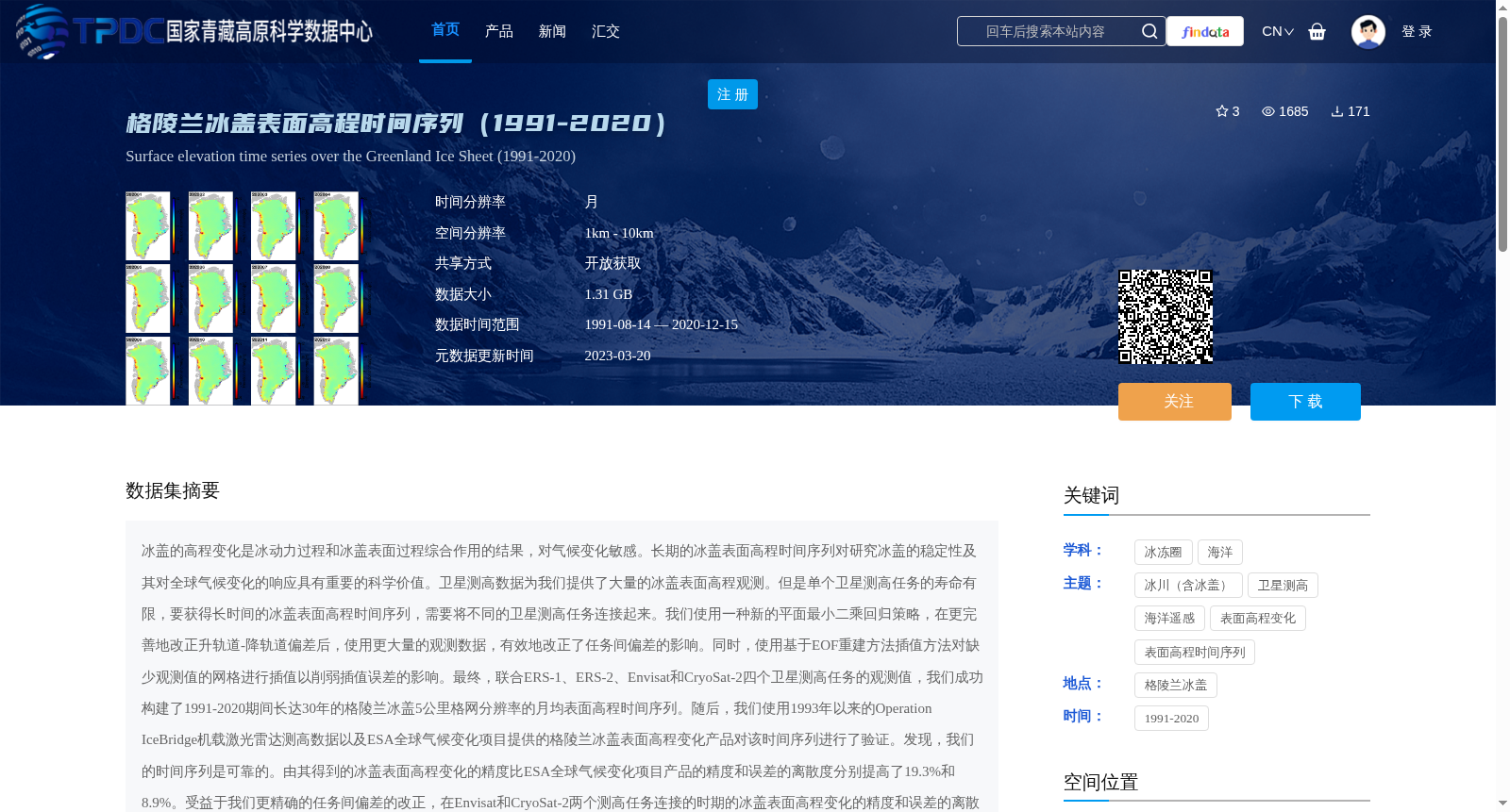
冰盖的高程变化是冰动力过程和冰盖表面过程综合作用的结果,对气候变化敏感。长期的冰盖表面高程时间序列对研究冰盖的稳定性及其对全球气候变化的响应具有重要的科学价值。卫星测高数据为我们提供了大量的冰盖表面高程观测。但是单个卫星测高任务的寿命有限,要获得长时间的冰盖表面高程时间序列,需要将不同的卫星测高任务连接起来。我们使用一种新的平面最小二乘回归策略,在更完善地改正升轨道-降轨道偏差后,使用更大量的观测数据,有效地改正了任务间偏差的影响。同时,使用基于EOF重建方法插值方法对缺少观测值的网格进行插值以削弱插值误差的影响。最终,联合ERS-1、ERS-2、Envisat和CryoSat-2四个卫星测高任务的观测值,我们成功构建了1991-2020期间长达30年的格陵兰冰盖5公里格网分辨率的月均表面高程时间序列。随后,我们使用1993年以来的Operation IceBridge机载激光雷达测高数据以及ESA全球气候变化项目提供的格陵兰冰盖表面高程变化产品对该时间序列进行了验证。发现,我们的时间序列是可靠的。由其得到的冰盖表面高程变化的精度比ESA全球气候变化项目产品的精度和误差的离散度分别提高了19.3%和8.9%。受益于我们更精确的任务间偏差的改正,在Envisat和CryoSat-2两个测高任务连接的时期的冰盖表面高程变化的精度和误差的离散度提高的更多,分别达到30.9%和19.0%。基于该套数据,我们发现近30年来格陵兰冰盖的体积以初始速率-53.8 ± 4.5 km3/yr,加速度-2.2 ± 0.3 km3/yr2加速损失。同时,我们还发现北大西洋涛动的相位转换对格陵兰冰盖表面高程的变化有着显著的影响。此外,该数据还是评估格陵兰冰盖质量平衡及其对全球海平面的贡献和研究格陵兰冰盖对气候变化的响应过程与机制的重要基础数据。
Elevation changes of ice sheets are the combined result of ice dynamic processes and ice sheet surface processes, and are sensitive to climate change. Long-term ice sheet surface elevation time series are of great scientific significance for studying ice sheet stability and its response to global climate change. Satellite altimetry data provide abundant observations of ice sheet surface elevations. However, the service life of a single satellite altimetry mission is limited. To acquire long-duration ice sheet surface elevation time series, observations from different satellite altimetry missions need to be integrated. We employed a novel planar least-squares regression framework to more comprehensively correct the ascending-descending orbit bias, and leveraged a larger set of observational data to effectively correct inter-mission biases. Meanwhile, we applied an interpolation method based on EOF reconstruction to fill missing grid observations, so as to weaken the impact of interpolation errors. Finally, by combining observations from four satellite altimetry missions including ERS-1, ERS-2, Envisat and CryoSat-2, we successfully constructed a 30-year (1991–2020) monthly mean surface elevation time series of the Greenland Ice Sheet at a 5 km grid resolution. Subsequently, we validated this time series using Operation IceBridge airborne lidar altimetry data since 1993 and the Greenland Ice Sheet surface elevation change product provided by the ESA Climate Change Initiative. The results demonstrate that our time series is reliable. The accuracy of ice sheet surface elevation change derived from our data is improved by 19.3% and the dispersion of errors is enhanced by 8.9% compared to the ESA Climate Change Initiative product. Benefiting from our more precise correction of inter-mission biases, the accuracy of ice sheet surface elevation change and the dispersion of errors during the overlapping period of Envisat and CryoSat-2 missions increased more notably, reaching 30.9% and 19.0% respectively. Based on this dataset, we found that over the past 30 years, the Greenland Ice Sheet has undergone accelerated mass loss at an initial rate of -53.8 ± 4.5 km³/yr and an acceleration of -2.2 ± 0.3 km³/yr². Meanwhile, we also discovered that the phase transition of the North Atlantic Oscillation exerts a significant impact on the changes in the Greenland Ice Sheet surface elevation. In addition, this dataset serves as an important fundamental data for assessing the mass balance of the Greenland Ice Sheet, its contribution to global sea level rise, and investigating the response processes and mechanisms of the Greenland Ice Sheet to climate change.
提供机构:
张保军,王泽民,安家春,刘婷婷,耿红
创建时间:
2021-08-25
搜集汇总
数据集介绍
背景与挑战
背景概述
该数据集提供了1991-2020年期间格陵兰冰盖表面高程的月均时间序列,空间分辨率为5公里,数据大小为1.31 GB。通过联合ERS-1、ERS-2、Envisat和CryoSat-2四个卫星测高任务的观测值,构建了高精度的冰盖表面高程变化数据,并验证了其可靠性,为研究冰盖稳定性及其对气候变化的响应提供了重要基础数据。
以上内容由遇见数据集搜集并总结生成


