中国内陆水体氮沉降数据集(1990s-2010s)
收藏国家生态科学数据中心2024-03-04 收录
下载链接:
http://www.nesdc.org.cn/sdo/detail?id=64e493a07e2817429fbc7ae6
下载链接
链接失效反馈官方服务:
资源简介:
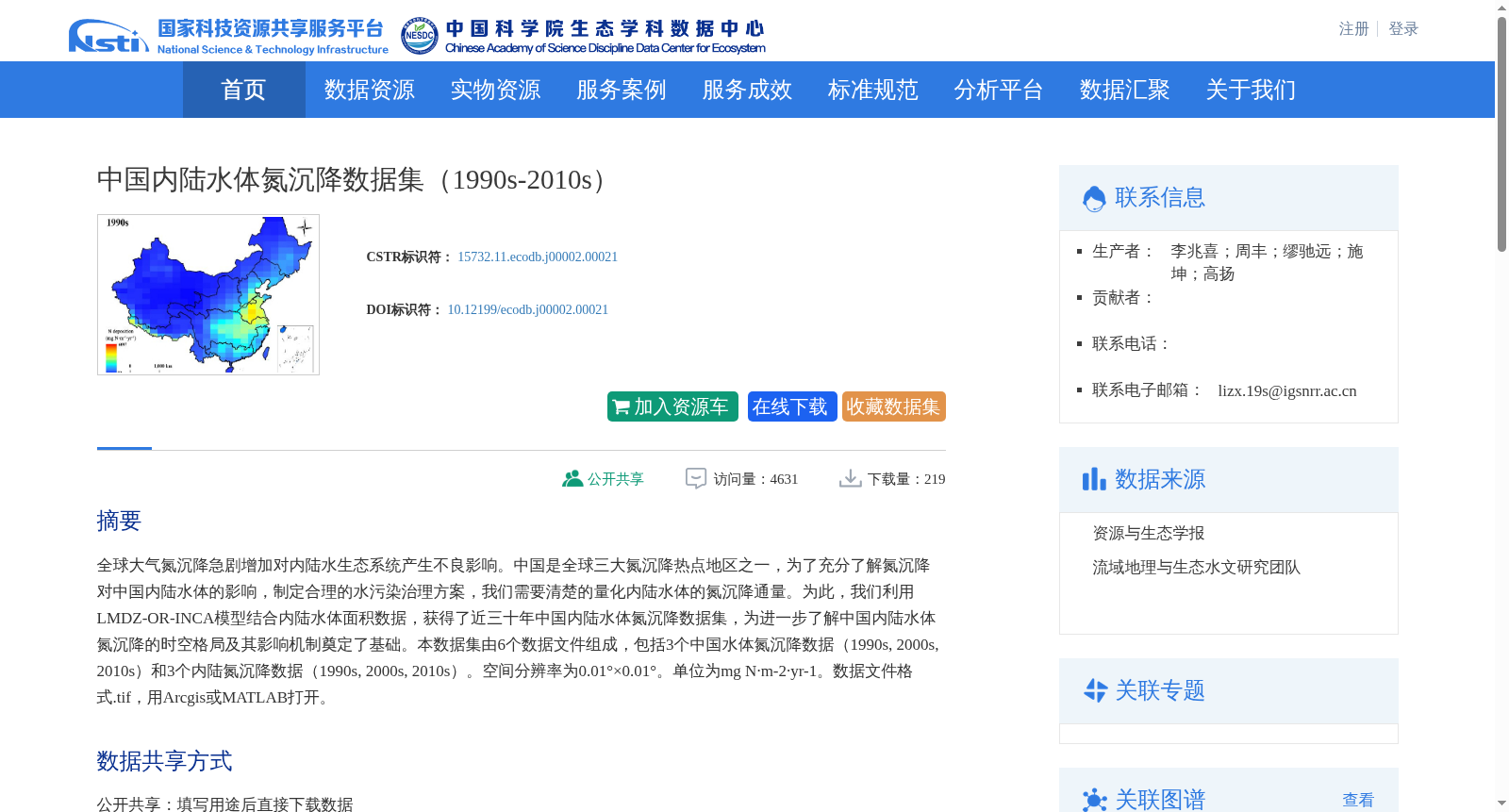
全球大气氮沉降急剧增加对内陆水生态系统产生不良影响。中国是全球三大氮沉降热点地区之一,为了充分了解氮沉降对中国内陆水体的影响,制定合理的水污染治理方案,我们需要清楚的量化内陆水体的氮沉降通量。为此,我们利用LMDZ-OR-INCA模型结合内陆水体面积数据,获得了近三十年中国内陆水体氮沉降数据集,为进一步了解中国内陆水体氮沉降的时空格局及其影响机制奠定了基础。本数据集由6个数据文件组成,包括3个中国水体氮沉降数据(1990s, 2000s, 2010s)和3个内陆氮沉降数据(1990s, 2000s, 2010s)。空间分辨率为0.01°×0.01°。单位为mg N·m-2·yr-1。数据文件格式.tif,用Arcgis或MATLAB打开。
Global atmospheric nitrogen deposition has been increasing dramatically, exerting adverse impacts on inland aquatic ecosystems. China is one of the three global hotspots of nitrogen deposition. To fully comprehend the impacts of nitrogen deposition on China’s inland waters and develop rational water pollution control schemes, it is essential to accurately quantify the nitrogen deposition flux over inland water bodies. To this end, we combined the LMDZ-OR-INCA model with inland water area data to establish a dataset of nitrogen deposition over China’s inland waters spanning the past three decades. This dataset lays a solid foundation for further exploring the spatiotemporal patterns and underlying mechanisms of nitrogen deposition in China’s inland waters. This dataset consists of six data files, including three datasets of nitrogen deposition over Chinese waters (1990s, 2000s, 2010s) and three datasets of inland nitrogen deposition (1990s, 2000s, 2010s). The spatial resolution is 0.01° × 0.01°. The unit is mg N·m⁻²·yr⁻¹. The data files are in .tif format and can be opened using ArcGIS or MATLAB.
创建时间:
2022-10-10
搜集汇总
数据集介绍
背景与挑战
背景概述
该数据集提供了中国内陆水体在1990年代至2010年代的氮沉降时空数据,基于LMDZ-OR-INCA模型生成,空间分辨率为0.01°×0.01°,旨在量化氮沉降通量以评估其对水生态系统的影响。数据集包含6个栅格文件,覆盖三个时期,适用于生态学和水污染治理研究,需用专业软件如Arcgis或MATLAB打开使用。
以上内容由遇见数据集搜集并总结生成


