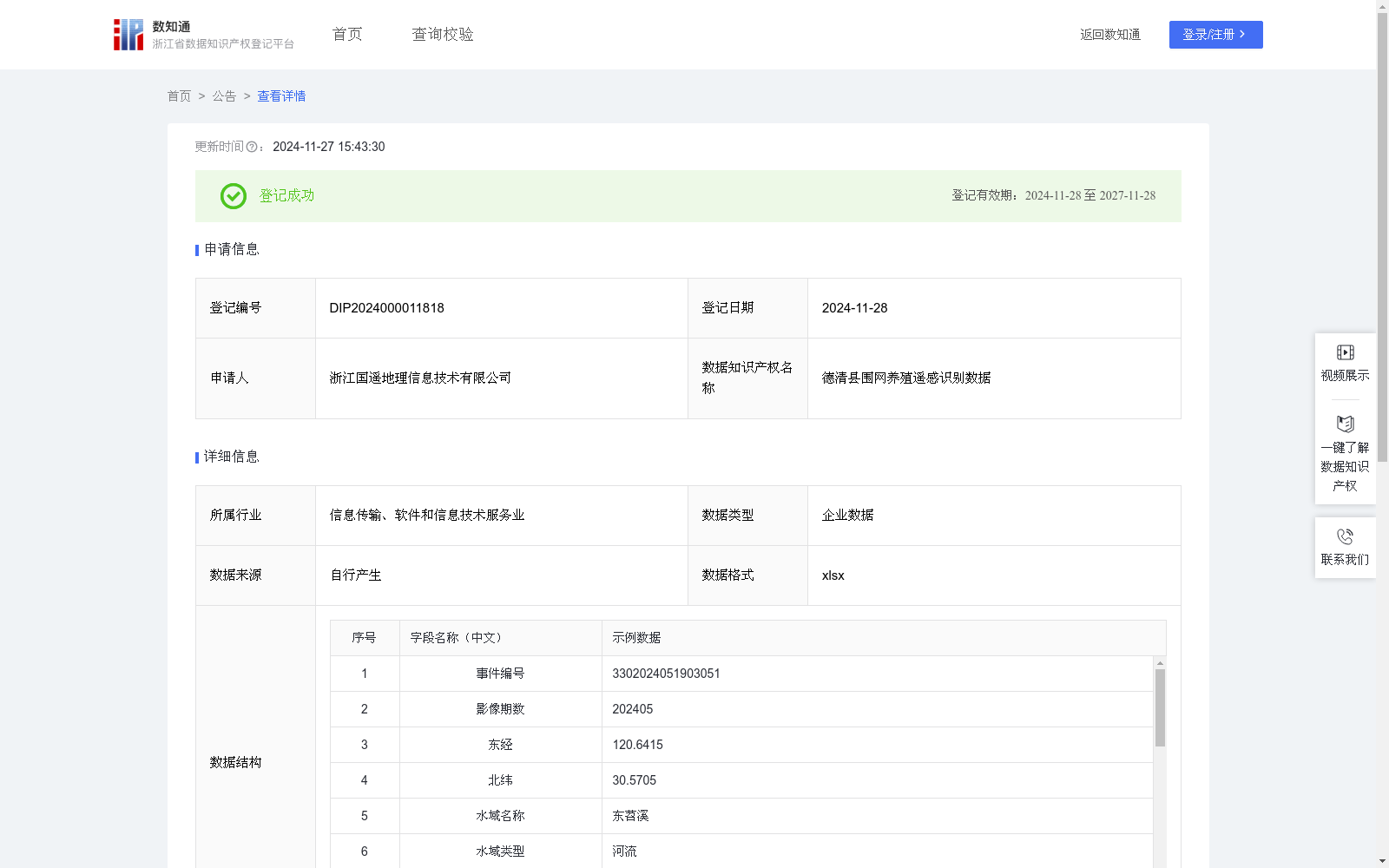
德清县围网养殖遥感识别数据
收藏浙江省数据知识产权登记平台2024-11-27 更新2024-11-28 收录
下载链接:
https://www.zjip.org.cn/home/announce/trends/90138
下载链接
链接失效反馈官方服务:
资源简介:
用于实现对围网养殖监测中问题点位的高效精准识别,旨在提升养殖监管效率,解决基层人员在广阔水域中难以高效巡查的问题。该数据通过精准识别养殖区域变化,自动记录点位坐标,帮助监管人员及时发现非法养殖、水域污染等问题,有效维护水域生态安全。同时,数据的应用有助于简化基层人员的工作流程,将传统的人工巡查与现代化技术手段相结合,为围网养殖管理提供科学、便捷的解决方案。利用无人机航拍技术采集的2024年5月围网养殖遥感影像数据,通过YOLO算法实现目标检测。通过预测每个区域的概率,选取所有单元格中概率最大的类别,并将其分配给相应的网格单元。根据预测概率生成加权边界框,进行非极大值抑制(NMS)运算,以消除多余的锚点。算法会识别出概率次高的边界框,并重复相同的处理过程,直到所有不同的边界框均被筛选出来并计算得出识别准确度,该准确度越接近1,表明地块识别越精确;若小于0.6,则视为识别错误。基于这一判断,将正确识别的地块纳入数据集,同时排除识别错误的样本。
对于识别正确的地块,进一步计算其区域中心坐标(x,y),并采用CGCS2000坐标系进行定位,坐标默认采用东经、北纬格式。通过先进算法分析影像中的特征区域,自动识别并提取养殖类型,利用水体颜色参量与水体透明度之间的相关关系来构建透明度遥感估算模型,从而计算水体透明度指数。根据围网养殖地块在当前识别框中的相对位置(x1,y1),(x2,y2),(x3,y3),(x4,y4),通过四个角标位置计算相对面积area,再结合遥感影像的分辨率和比例尺计算围网面积(平方米)。最终,这些特征区域的坐标、类型及其他相关信息将被自动上传至德清水利数字化遥感监测平台,从而实现对德清地区围网养殖问题的精准监测与数据分析。
This dataset is designed to efficiently and accurately identify problematic sites in pen aquaculture monitoring, aiming to improve the efficiency of aquaculture supervision and solve the problem that grassroots personnel find it difficult to conduct efficient patrols in vast water areas. By accurately identifying changes in aquaculture areas and automatically recording the coordinates of sites, it helps supervisors timely detect issues such as illegal aquaculture and water pollution, effectively maintaining the ecological security of water areas. Meanwhile, the application of this dataset helps simplify the work processes of grassroots personnel, combines traditional manual patrols with modern technological means, and provides scientific and convenient solutions for pen aquaculture management.
The remote sensing image data of pen aquaculture collected in May 2024 via UAV aerial photography is subjected to object detection using the YOLO algorithm. The algorithm predicts the probability of each region, selects the category with the highest probability among all grid cells, and assigns it to the corresponding grid unit. Weighted bounding boxes are generated based on the predicted probabilities, and Non-Maximum Suppression (NMS) operation is performed to eliminate redundant anchor boxes. The algorithm then identifies the bounding box with the second-highest probability and repeats the same processing procedure until all distinct bounding boxes are screened out and the recognition accuracy is calculated. The closer the accuracy is to 1, the more accurate the plot recognition is; if the accuracy is less than 0.6, it is regarded as a recognition error. Based on this judgment, correctly recognized plots are included in the dataset, while misrecognized samples are excluded.
For correctly recognized plots, the regional central coordinates (x, y) are further calculated, and positioning is carried out using the CGCS2000 coordinate system, with the coordinates defaulting to the East longitude and North latitude format. Advanced algorithms are used to analyze the feature regions in the images, automatically identify and extract aquaculture types, and build a remote sensing estimation model for transparency using the correlation between water color parameters and water transparency, thereby calculating the water transparency index. According to the relative positions (x1, y1), (x2, y2), (x3, y3), (x4, y4) of the pen aquaculture plots in the current recognition frame, the relative area is calculated through the four corner point positions, and then the pen aquaculture area (in square meters) is calculated by combining the resolution and scale of the remote sensing image.
Finally, the coordinates, types and other relevant information of these feature regions will be automatically uploaded to the Deqing Water Conservancy Digital Remote Sensing Monitoring Platform, so as to achieve accurate monitoring and data analysis of pen aquaculture issues in the Deqing area.
提供机构:
浙江国遥地理信息技术有限公司
创建时间:
2024-10-17
搜集汇总
数据集介绍
特点
该数据集是德清县围网养殖的遥感识别数据,包含519条记录,通过无人机航拍和YOLO算法实现目标检测,用于精准识别养殖区域变化,提升养殖监管效率。数据包含经纬度坐标、水域名称、养殖类型、围网面积等关键字段,适用于围网养殖监测和生态安全管理。
以上内容由遇见数据集搜集并总结生成


