基于多源测深数据约束反演南海海域高精度海底地形
收藏国家青藏高原科学数据中心2024-08-22 更新2025-01-25 收录
下载链接:
https://data.tpdc.ac.cn/zh-hans/data/4eda0c28-bf9a-440c-9d0d-7a63fc5e2437
下载链接
链接失效反馈官方服务:
资源简介:
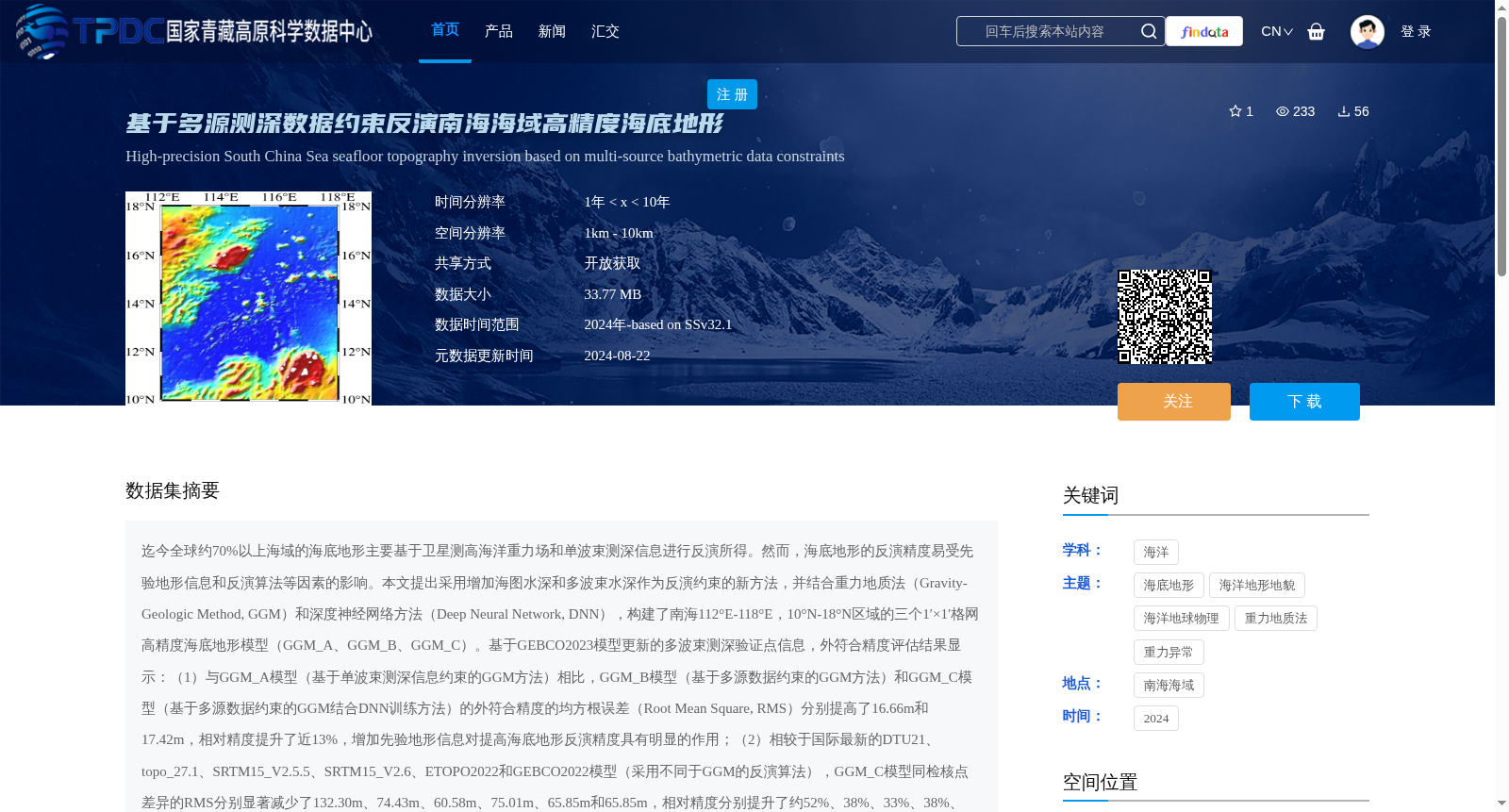
迄今全球约70%以上海域的海底地形主要基于卫星测高海洋重力场和单波束测深信息进行反演所得。然而,海底地形的反演精度易受先验地形信息和反演算法等因素的影响。本文提出采用增加海图水深和多波束水深作为反演约束的新方法,并结合重力地质法(Gravity-Geologic Method, GGM)和深度神经网络方法(Deep Neural Network, DNN),构建了南海112°E-118°E,10°N-18°N区域的三个1′×1′格网高精度海底地形模型(GGM_A、GGM_B、GGM_C)。基于GEBCO2023模型更新的多波束测深验证点信息,外符合精度评估结果显示:(1)与GGM_A模型(基于单波束测深信息约束的GGM方法)相比,GGM_B模型(基于多源数据约束的GGM方法)和GGM_C模型(基于多源数据约束的GGM结合DNN训练方法)的外符合精度的均方根误差(Root Mean Square, RMS)分别提高了16.66m和17.42m,相对精度提升了近13%,增加先验地形信息对提高海底地形反演精度具有明显的作用;(2)相较于国际最新的DTU21、topo_27.1、SRTM15_V2.5.5、SRTM15_V2.6、ETOPO2022和GEBCO2022模型(采用不同于GGM的反演算法),GGM_C模型同检核点差异的RMS分别显著减少了132.30m、74.43m、60.58m、75.01m、65.85m和65.85m,相对精度分别提升了约52%、38%、33%、38%、35%和35%。表明GGM方法在先验地形信息的约束条件下,充分发挥了短波尺度上重力异常与地形的相关性,反演得到的海底地形模型在南海研究区域中明显优于其它模型。总之,充分利用多源测深信息作为约束条件的重力地质法(GGM)是反演高精度海底地形的有效手段之一,结合GGM的深度神经网络方法能够在一定程度上提高反演精度。
To date, the seafloor topography of over 70% of the global oceans has been primarily inverted using satellite altimetry-derived marine gravity fields and single-beam bathymetry data. However, the inversion accuracy of seafloor topography is readily affected by factors such as prior terrain information and inversion algorithms. This paper presents a novel approach that incorporates charted water depth and multi-beam bathymetry as inversion constraints, and combines the Gravity-Geologic Method (GGM) and Deep Neural Network (DNN) to develop three 1′×1′ grid high-precision seafloor topographic models (GGM_A, GGM_B, GGM_C) for the South China Sea region between 112°E–118°E and 10°N–18°N. Based on the updated multi-beam bathymetry validation point dataset from the GEBCO2023 model, the external accuracy evaluation results demonstrate that: (1) Compared with the GGM_A model (GGM method constrained by single-beam bathymetry data), the Root Mean Square (RMS) errors of the external matching accuracy for GGM_B (multi-source data constrained GGM method) and GGM_C (multi-source data constrained GGM combined with DNN training) increased by 16.66 m and 17.42 m respectively, with the relative accuracy improved by nearly 13%, confirming that adding prior terrain information significantly enhances the inversion accuracy of seafloor topography; (2) Compared with the latest international models including DTU21, topo_27.1, SRTM15_V2.5.5, SRTM15_V2.6, ETOPO2022 and GEBCO2022 (which utilize inversion algorithms distinct from GGM), the RMS differences between the GGM_C model and the check points decreased notably by 132.30 m, 74.43 m, 60.58 m, 75.01 m, 65.85 m and 65.85 m respectively, corresponding to relative accuracy improvements of approximately 52%, 38%, 33%, 38%, 35% and 35% respectively. These findings indicate that under the constraint of prior terrain information, the GGM method fully exploits the correlation between gravity anomalies and topography at short-wave scales, and the inverted seafloor topographic model outperforms other models significantly in the South China Sea study area. In conclusion, the Gravity-Geologic Method (GGM) that fully leverages multi-source bathymetry data as constraints represents one of the effective approaches for inverting high-precision seafloor topography, and the DNN-augmented GGM method can further improve inversion accuracy to a certain extent.
提供机构:
陈晓东
创建时间:
2024-08-21
搜集汇总
数据集介绍
背景与挑战
背景概述
该数据集是基于多源测深数据约束反演方法构建的南海海域高精度海底地形模型,包含三个1′×1′格网模型(GGM_A、GGM_B、GGM_C),通过增加海图水深和多波束水深作为反演约束,结合重力地质法和深度神经网络方法,显著提高了海底地形反演的精度。数据集以netcdf格式提供,分辨率为1′,适用于海洋地形地貌和海洋地球物理研究。
以上内容由遇见数据集搜集并总结生成


