Ottawa, Farmland, Yellow River, San Francisco, Sulzberger
收藏资源简介:
Farmland数据集由RADARSAT-2在中国黄河口地区于2008年6月和2009年6月分别获取。两幅图像分别为单视和四视图像,因此2008年捕获的图像受到斑点噪声的影响远大于2009年获取的图像。Yellow River数据集同样由RADARSAT-2在中国黄河口地区于2008年6月和2009年6月分别获取。两幅图像分别为单视和四视图像,因此2008年捕获的图像受到斑点噪声的影响远大于2009年获取的图像。San Francisco数据集展示了由ERS-2传感器获取的多时相SAR图像,分别在2003年8月和2004年5月捕获。Sulzberger数据集由Envisat卫星于2011年3月11日和16日捕获,两幅图像显示了冰块破裂的进展。
The Farmland dataset was acquired by RADARSAT-2 in the Yellow River Estuary region of China in June 2008 and June 2009. The two images are single-look and four-look images, respectively, hence the image captured in 2008 is significantly more affected by speckle noise compared to the one acquired in 2009. The Yellow River dataset was also captured by RADARSAT-2 in the Yellow River Estuary region of China in June 2008 and June 2009. The two images are single-look and four-look images, respectively, thus the image from 2008 is considerably more impacted by speckle noise than the one from 2009. The San Francisco dataset presents multi-temporal SAR images acquired by the ERS-2 sensor, captured in August 2003 and May 2004. The Sulzberger dataset was captured by the Envisat satellite on March 11 and 16, 2011, with the two images showing the progression of ice breakup.
数据集概述
本数据集包含多个用于SAR变化检测的数据集,具体包括:
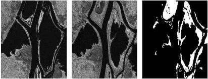
1. Ottawa
- 数据链接:Ottawa_data.zip
- 图片示例:
2. Farmland
- 数据链接:Farmland_data.zip
- 图片示例:
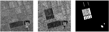
- 数据描述:该数据集由RADARSAT-2在中国黄河口地区于2008年6月和2009年6月分别获取。两幅图像分别为单视和四视图像,因此2008年图像的斑点噪声影响大于2009年。
3. Yellow River
- 数据链接:Yellowriver_data.zip
- 图片示例:
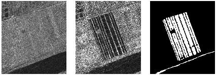
- 数据描述:该数据集由RADARSAT-2在中国黄河口地区于2008年6月和2009年6月分别获取。两幅图像分别为单视和四视图像,因此2008年图像的斑点噪声影响大于2009年。
4. San Francisco
- 数据链接:San Francisco Dataset
- 图片示例:
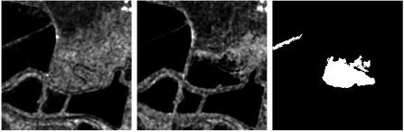
- 数据描述:该数据集展示了由ERS-2传感器获取的多时相SAR图像,分别在2003年8月和2004年5月捕获。引用信息:Feng Gao, Junyu Dong, Bo Li, Qizhi Xu, and Cui Xie, "Change detection from synthetic aperture radar images based on neighborhood-based ratio and extreme learning machine," Journal of Applied Remote Sensing, 10(4), 046019, Dec. 2016. doi: 10.1117/1.JRS.10.046019.
5. Sulzberger
- 数据链接:Sulzberger Dataset
- 图片示例:
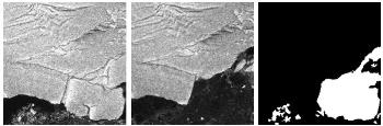
- 数据描述:该数据集由Envisat卫星于2011年3月11日和16日捕获,显示了冰裂的进展。2011年3月11日太平洋发生Tohoku海啸时,巨大的海浪导致冰架弯曲和断裂。引用信息:F. Gao, X. Wang, Y. Gao, J. Dong and S. Wang, "Sea Ice Change Detection in SAR Images Based on Convolutional-Wavelet Neural Networks," IEEE Geoscience and Remote Sensing Letters, vol. 16, no. 8, pp. 1240-1244, Aug. 2019, doi: 10.1109/LGRS.2019.2895656.