1980年中国1:100万植被图
收藏地球大数据科学工程2024-03-04 收录
下载链接:
https://data.casearth.cn/sdo/detail/5c19a5680600cf2a3c557b6b
下载链接
链接失效反馈官方服务:
资源简介:
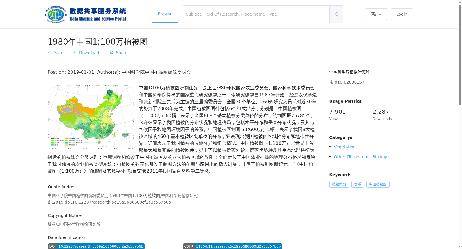
中国1∶100万植被图研制任务,是上世纪80年代国家农业委员会、国家科学技术委员会和中国科学院提出的国家重点研究课题之一。该研究课题自1983年开始,经过以侯学煜和张新时院士先后为主编的三届编委员会、全国70个单位、260余研究人员耗时近30年的努力于2008年完成。中国植被图图件包括6个组成部分,分别是:中国植被图(1∶100万)60幅,表示了全国868个基本植被分类单位的分布,绘制图斑75785个。它详细显示了我国植被的分布状况和地理格局,包括水平分布和垂直分布状况,及其与气候因子和地面环境因子的关系。中国植被区划图(1∶600万)1幅,表示了我国8大植被区域的460年基本植被区划单位的分布,它表现出我国植被的区域性分布和地带性分异,详细表示了我国植被的局地分异和组合情况。中国植被图(1:100万)是世界上首部最大和最完备的植被图件;提出了以植被群落外貌、群落优势种及其生态地理特征为指标的植被综合分类原则;重新调整和修改了中国植被区划的八大植被区域的界限;全面定位了中国农业植被的地理分布格局和反映了我国独特的农业植被类型系统;植被图的数字化引发了制图方法的创新与应用上的极大进展,开启了植被制图新纪元。“《中国植被图(1:100万)》的编研及其数字化”项目荣获2011年度国家自然科学二等奖。
The development of the 1:1000000 Vegetation Map of China was one of the national key research projects proposed by the State Agricultural Commission, State Science and Technology Commission, and Chinese Academy of Sciences in the 1980s. Initiated in 1983, this research project was completed in 2008 after nearly 30 years of work by three successive editorial boards—with Academicians Hou Xueyu and Zhang Xinshi serving as chief editors in turn, 70 institutions across the country, and over 260 researchers. The Vegetation Map of China comprises six components: 1) Sixty sheets of the 1:1000000 Vegetation Map of China, which illustrate the distribution of 868 basic vegetation classification units across the nation, with 75785 mapping patches plotted. It thoroughly displays the distribution and geographic pattern of China’s vegetation, including its horizontal and vertical distributions, as well as their correlations with climatic and terrestrial environmental factors. 2) One sheet of the 1:6000000 Vegetation Regionalization Map of China, which represents the distribution of 460 basic vegetation regionalization units within China’s eight major vegetation regions. This map reveals the regional and zonal differentiation of China’s vegetation, and details the local differentiation and assemblage of vegetation across the country. The 1:1000000 Vegetation Map of China stands as the largest and most comprehensive vegetation mapping product worldwide. It put forward a comprehensive vegetation classification principle that takes the physiognomy of vegetation communities, dominant species of the communities, and their eco-geographical characteristics as core indicators; readjusted and revised the boundaries of China’s eight major vegetation regions; fully pinpointed the geographic distribution pattern of China’s agricultural vegetation and reflected China’s unique agricultural vegetation type system. The digitization of the vegetation map has spurred significant innovations in mapping methodologies and applications, opening a new era for vegetation mapping. The project titled "Compilation and Digitization of the 1:1000000 Vegetation Map of China" was awarded the Second Class Prize of the National Natural Science Award in 2011.
提供机构:
中国科学院植物研究所
搜集汇总
数据集介绍
背景与挑战
背景概述
1980年中国1:100万植被图是由中国科学院中国植被图编辑委员会历时近30年完成的重大科研成果,包含60幅植被图和1幅植被区划图,详细展示了中国植被的分布状况和地理格局。该数据集为矢量数据(shpfile),空间分辨率为1:100万,时间分辨率为1980年代,地理范围覆盖全中国,是世界上首部最大和最完备的植被图件。
以上内容由遇见数据集搜集并总结生成


