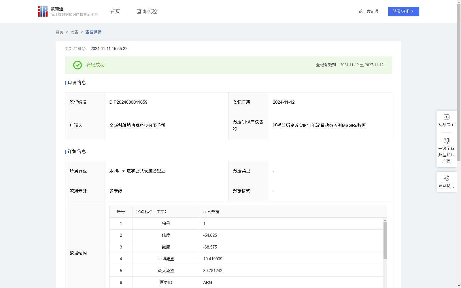
阿根廷历史近实时河流流量动态监测MSGRs数据
收藏浙江省数据知识产权登记平台2024-11-11 更新2024-11-12 收录
下载链接:
https://www.zjip.org.cn/home/announce/trends/83228
下载链接
链接失效反馈官方服务:
资源简介:
(一)洪涝灾害监测
在洪涝灾害期间,可提供洪水范围监测、洪水行进路线预测、溃口决堤监测、退水分析等能力;提供水文和水动力耦合模型综合洪水近实时观测、绘制历史和未来洪水AEP图、建立短期,中期和长期的洪水预报模型,为灾害管理提供决策支持;
(二)水资源管理
实现基于遥感的全流域水资源量的估算分析,并基于地物分类成果,实现了对农业、工程、生态、生活等不同需水类型的估算,为流域水资源供给平衡分析提供了数据支撑;
(三)河湖生态补水
实现对河流、湖泊、水库、坑塘等水域面积、水储量、历史长时序水面变化调查和高频次动态变化调查等方向的水资源基础调查的监测需;
(四)水利空间数据底板的动态更新
基于卫星遥感数据的生产,对数据底板进行周期性更新;
(五)构建、补足天空地一体化的流域水文监测站网
在缺乏地面监测区域、无实测值区域,提供了动态监测河流流量的手段,为该区域水文研究和水资源管理提供数据支持。(一)获取数据
采用MODIS遥感卫星数据,选择时间范围【编号】、空间范围【经度、纬度】。获取得到高光谱波段、高时间分辨率,和大范围覆盖的近实时测量值。
(二)算法规则
选取【水系ID】【流域ID】确定地表水范围,选取【平均流量】【最大流量】确定与模拟流量相关性强的MODIS像元,在0.55°×0.55°的搜索窗口中,利用W3模型的地表水范围与河流流量关联模型(MSGRs),进行观测分析和水范围估算。并通过Spearman和Pearson相关系数评估模型算法的性能。选取【编号】进行时间交叉验证,得到该区域内的预测河流流量【监测值】。
1. Flood Disaster Monitoring
During flood disasters, this dataset provides multiple capabilities including flood extent monitoring, flood routing prediction, dyke breach monitoring and recession analysis. It integrates hydrological and hydrodynamic coupled models to synthesize near-real-time flood observations, draws historical and future flood Annual Exceedance Probability (AEP) maps, and establishes short-, medium- and long-term flood forecasting models to provide decision support for disaster management.
2. Water Resource Management
It realizes estimation and analysis of whole-basin water resources based on remote sensing data. Combined with land cover classification results, it estimates water demand of different types such as agricultural, engineering, ecological and domestic water use, providing data support for basin water supply balance analysis.
3. River and Lake Ecological Water Replenishment
It meets the monitoring demands of basic water resource surveys, including surveys of water areas (such as rivers, lakes, reservoirs and ponds), water storage, long-term time-series water surface changes and high-frequency dynamic water surface changes.
4. Dynamic Update of Water Conservancy Spatial Data Platform
It performs periodic updates of the data platform based on satellite remote sensing data production.
5. Construction and Complementation of Space-Air-Ground Integrated Basin Hydrological Monitoring Network
In areas lacking ground monitoring or with no in-situ measured data, it provides a means for dynamic river flow monitoring, offering data support for hydrological research and water resource management in these regions.
(1) Data Acquisition
MODIS remote sensing satellite data is adopted, with the time range [Number] and spatial range [Longitude, Latitude] selected. Near-real-time measurements with hyperspectral bands, high temporal resolution and wide-area coverage are obtained.
(2) Algorithm Rules
Select [Water System ID] and [Basin ID] to determine the surface water extent. Select [Average Flow] and [Maximum Flow] to identify MODIS pixels with strong correlation to simulated flow. Within a 0.55°×0.55° search window, the Surface Water Extent and River Flow Correlation Model (MSGRs) of the W3 model is used to conduct observational analysis and water extent estimation. The performance of the model algorithm is evaluated using Spearman's and Pearson's correlation coefficients. Temporal cross-validation is performed using [Number] to obtain the predicted river flow [Monitoring Value] in this region.
提供机构:
金华科维城信息科技有限公司
创建时间:
2024-10-16
搜集汇总
数据集介绍
特点
阿根廷历史近实时河流流量动态监测MSGRs数据集包含1016条记录,每8天更新一次,主要用于洪涝灾害监测、水资源管理等领域。数据通过MODIS遥感卫星获取,利用W3和MSGRs模型进行流量预测和分析。
以上内容由遇见数据集搜集并总结生成


