A dataset of distributions and characteristics of debris flows in the China-Nepal Traffic Corridor along the 318 National Highway(2022)
收藏DataCite Commons2025-02-02 更新2025-04-16 收录
下载链接:
https://www.scidb.cn/en/detail?dataSetId=bccb9c1fe37a4e98aca4c4a7cce1665e
下载链接
链接失效反馈官方服务:
资源简介:
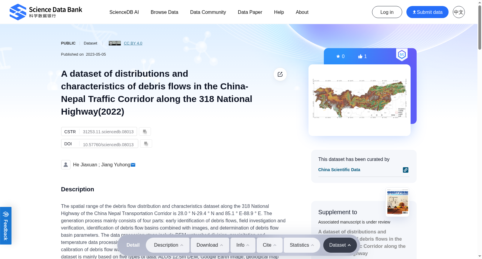
The spatial range of the debris flow distribution and characteristics dataset along the 318 National Highway of the China Nepal Transportation Corridor is 28.0 ° N-29.4 ° N and 85.1 ° E-88.9 ° E. The generation process mainly consists of four parts: early identification of debris flows, field investigation and verification, identification of debris flow basins combined with images, and determination of debris flow basin parameters. The data processing steps include DEM watershed division, precipitation and temperature data processing, geological data processing such as stratigraphic lithology and faults, calibration of debris flow watershed range, and extraction of debris flow watershed parameters. The dataset is mainly based on five types of data: ALOS 12.5m DEM, Google Earth image, geological map (1:500000), annual precipitation (1980-2009), and annual average temperature (1980-2009) for the China Nepal transportation corridor. The dataset of 255 debris flow records consists of three sub-datasets: 1) a vector file that defines the main distribution areas of debris flows in the China-Nepal Traffic Corridor along the 318 National Highway; 2) a vector file of debris flow catalogue; 3) the statistics for each debris flow gully, including such parameters as code, outfall longitude, outfall latitude, watershed area, average elevation, relative elevation difference, maximum slope, average slope, gully bed gradient, lithology classification value, fault density, average annual precipitation, average annual temperature, river network density, etc.
中尼交通走廊G318国道沿线泥石流分布与特征数据集的空间范围为北纬28.0°~29.4°、东经85.1°~88.9°。该数据集的生成流程主要包含四个环节:泥石流前期识别、野外调查验证、结合影像的泥石流流域识别、泥石流流域参数确定。数据处理步骤涵盖DEM(数字高程模型)流域划分、降水与气温数据处理、地层岩性及断层等地质数据处理、泥石流流域范围校准以及泥石流流域参数提取。本数据集主要依托五类基础数据:中尼交通走廊范围内的ALOS 12.5米分辨率DEM、谷歌地球(Google Earth)影像、1:50万地质图、1980-2009年年均降水量数据以及1980-2009年年均气温数据。本数据集共包含255条泥石流记录,分为三个子数据集:1) 用于划定中尼交通走廊G318国道沿线泥石流主要分布区域的矢量文件;2) 泥石流名录矢量文件;3) 单条泥石流沟的统计参数,具体包括编码、沟口经度、沟口纬度、流域面积、平均海拔、相对高差、最大坡度、平均坡度、沟床纵比降、岩性分类值、断层密度、年均降水量、年均气温、河网密度等。
提供机构:
Science Data Bank
创建时间:
2023-05-05
搜集汇总
数据集介绍
背景与挑战
背景概述
该数据集聚焦于中国-尼泊尔交通走廊沿318国道的泥石流分布与特征,空间范围为28.0°N-29.4°N和85.1°E-88.9°E。数据集包含255条泥石流记录,基于ALOS DEM、Google Earth图像等多源数据生成,涵盖泥石流沟谷的代码、地理坐标、流域面积、地形坡度、地质条件和气候参数等多维特征,旨在支持地质灾害研究与防治。
以上内容由遇见数据集搜集并总结生成


